First Responder Support Tools
Features of the software include:
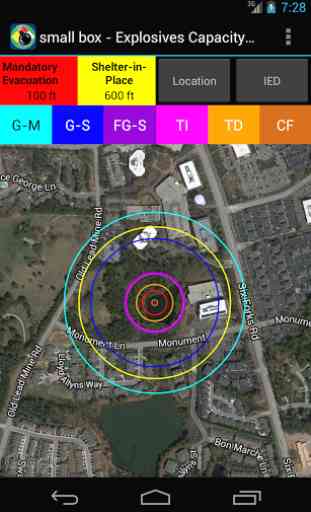
- Display IED Mandatory Evacuation and Shelter-in-Place Zones for 8 pre-defined bomb sizes and user defined custom IED types
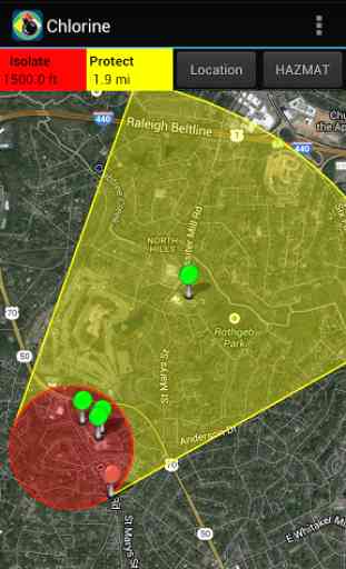
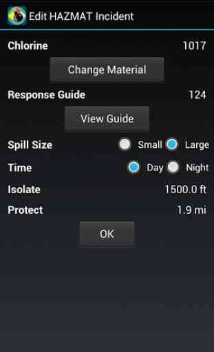
- Display Isolation Zones and down-wind Protection Zones for over 3,000 chemicals
- Display distance to glass breakage, injury, and structural damage based on bomb size
- Information displayed on Google Maps, with similar functionality to zoom, search by address, current location, and map/satellite/hybrid views
- Automatically retrieve current weather from Weatherbug (www.weather.weatherbug.com) or forecast weather from the National Weather Service (US only) or Meteorologisk Institutt (Worldwide); weather can also be user input or input using the phone’s compass functionality
- Results shown geographically as well as text based
- Search and display predefined points of interest (schools, nurseries, hospitals, police/fire stations, and government facilities) from Google Search services to identify key facilities within the incident area
- Run roadblock analysis service that identifies within seconds the optimal location of roadblocks to isolate the incident area
- Place and label points on the map to identify key locations
- One-button summary of results (text, map image, map data shape and kml file attachments) in an email to disseminate to other responding personnel
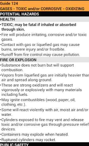
- Includes reference material from the 2012 ERG and important chemical contacts for quick calling
- Store map images (including legends) for reference when connectivity prevents access to network maps
For more information, go to http://www.firstsupporttools.com
Category : Books & Reference
Reviews (18)
Used to be great. App appears to not have been updated since 2017. Does not seem to work on android 10. No support after many emails and even phone calls to company. Anybody know of any alternatives?
Used this app on many emergency calls and it worked great. Unfortunately now is says it needs an update but there is no update available. The app has stopped working.
This was a great and helpful app. I have been in emergency services for over 37 years and this app was a great help but i can no longer get this app to work. Can someone please fix this?
This app WAS great.. . Got a new phone with Android 10.... Now it doesn't work. Please update
No longer works on newer Android phones. Needs updating.
It no longer works on newer Android devices
Complete junk. Half the features don't work. Can't even select a material for hazmat incident. What a joke. Thanks for taking my money.
Update your app please, won't work on newer Androids.
Doesn't open on my android, no response from developers.
Great tool
I use this app in my day to day job as a hazmat specialist and it is very useful.
Best app of it's kind and easy to use. Highly recommend.
Very limited, guess I'm a suckerrefers to free 2012 erg for data but does not post protective area or allow input. No measurement tools. Buyer beware - thought $12 would mean a professional app...not reading gps on galaxy s3 Very limited, refers to free 2012 erg for data but does not post protective area or allow input for many hazards. No measurement tools. Buyer beware - thought $12 would mean a professional app...not reading gps on galaxy s3. Better off with google earth and the erg book. Not user friendly. Should have known better with homeland security funding.
I highly recommend this tool for GOV Security Professionals!
Lots of stuff
I The apps ok but useless without the ied access code. Only works for a hazmat situation and Not worth $9.99! Too many similar apps for a small charge or better yet free.
as soon as I used this app I noticed the integration of many different, but familiar, resources makes FiRST every user friendly, fast and accurate.
App needs an update, when using on older Android systems the App was an awesome tool for first responders. Along with updating the compatibility with new Android systems, the ERG info needs to be updated to the 2020 Edition. Once updated, I would rate this app a 10 out of 5 stars. Hopefully it is updated soon.