FlightAssistant
* WARNING TO EUROPEAN USERS ***Flight Assistant version 2 (see applications from the same publisher) has been made available to most countries in Europe.The version 1 aeronautical data for those countries is not maintained anymore.If Flight Assistant version 2 is available in your country, you would much rather install and use version 2.**
* /// ***
FlightAssistant is an aviation "moving map" GPS application.
Developed by pilots, it will be your best co-pilot on your Android phone or tablet.
Prepare your flight, download AIP (aeronautical) data, NOTAMs and weather data as well as airport charts (only available in selected countries) and you are ready to take off.
FlightAssistant will help you to follow the flight plan that you have defined and will provide you with all the information you might need in flight.
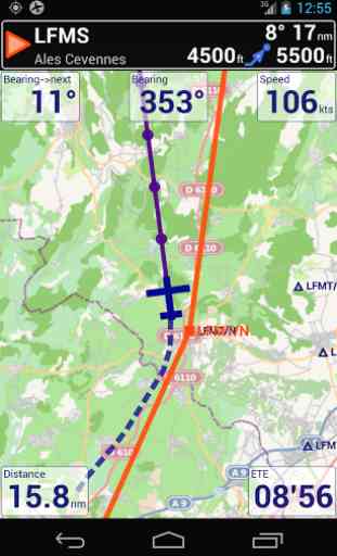
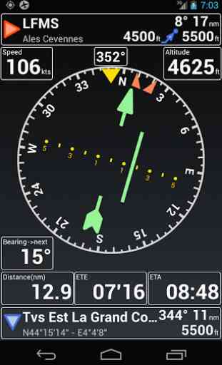
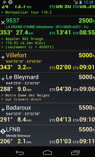
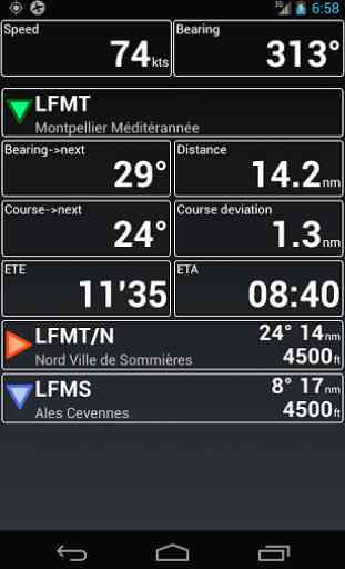
Main features...•Multi-zoom moving map (can show either North up or track up)•Airspaces awareness and alerts•Horizontal situation indicator•Integrated maps library (free maps)•Flight preparation: create a flight plan from aeronautical or user waypoints•Weight & balance: flexible weight and balance calculation (user defined weight station, CG limits, etc.)•Electronic navigation log with offline access to the route documents (airports charts & data, NOTAMs, METARs and TAFs)•Flight recording in Google Earth compliant format•Versatile usage modes; flight plan (prepared navigation), GOTO, or "free flight"•"Nearest" feature, providing a list of the closest airports•Download airport charts & diagrams for in flight offline use (only available for France and the US for now)•Download NOTAMs, METARs et TAFs for in flight offline use •Choose your units (metric or imperial for speed, distance and altitude)
Getting started ? Visit our website http://www.flightassistant.org/getting-started/. Please read the manual (http://www.flightassistant.org/assets/FlightAssistant_UG.pdf) and make yourself comfortable with the application before taking off.
Follow the application news on Twitter (https://twitter.com/droidfa) or Google+ (https://plus.google.com/111047533766475644105).This version of FlighAssistant uses "community" AIP data (airports, waypoints, etc.) and doesn't include official data provided by national or federal administrations.This application requires a GPS (either embedded or Bluetooth connected).
Category : Maps & Navigation
Reviews (28)
1 no longer supported and maps downloads have been removed. V2 does not show all airspaces. The whole point of the app for me is to avoid Gatwick Heathrow southampton and MATZ in class g such as Odiham. Boscombe down.
Very usable even in the free version. A good confidence giver when flying solo against a fully planned route. Can be quote confusing figuring out where some functions are, and not very intuitive at times.
Amazing especially to a private pilot though it doesn't have downloadable maps on African countries. Easy to use.
is not available for Africa..... it would be amazing a version for Kenya. I can supply chart if the proprammer need it
I wonder how I could fly without it. En France elle donne même les VAC, plus besoin de papiers ! :)
Love this app. Works great and has everything I need.
Very usefull
Simply a clunky interface. Made a flight plan. Have it loaded on the main screen, go to download documents and get the 'em you have not plans loaded message'. Confirmed it was loaded and it was. Overall non intuitive and too much hunting around to get things done. I have given this app two chances and it underwhelmed me both times.
Did a really good job
Like a lot of pilots, my phone is my third/ fourth backup. Haven’t tested in the air yet, but this looks like a great HSI for emergency mode. The HSI would be much easier to read under stress at night than some of the alternative apps I have looked at. Keep up the great work!!
This is a very intuitive and easy to use basic navigation app. Quick and easy to set up and has clear, sensible data and flight information. Keep up the great work.
excellent app for flying and navigation. would help to have a record function, invreased map interactivity (especially for flight plan preparation) and a desktop / web brother
Flight assistant turns my android phone into the perfect flight companion. The UI could be improved but is functional as is making it possible to plan flights and switch between views depending on your objective. Thank to the team for a great app
After creating a map folder on my micro SD card (Samsung Galaxy Tab 3) it will not let me connect to it saying 0 space on SD card even though it has 29 GB space left on it. SD card works with another Aviation APP. I can't find anything about how to remedy this problem.
Absolutely astounding. Very well done. Just missing TAWS, then it's 100%
I've used this app a few times for flight planning and it's very easy to use. Not tried flying with it yet but it looks to be well featured
Search for airports not working.
Amazing app, I just hope that in the next versions we'll be able to download charts, or better yet, Brazilian charts from AISWEB like another user mentioned before, and any other country where we can get free charts. Keep up the good work!
Any chance of charts for New Zealand.
I tried several ways to add Israel cvfr maps and airport's docs, but couldn't succed, hope you'll add it, on maprika all. Charts and maps available.
Not intuitive maps don't show. Always in OFF mode no matter what i tried. To create a flight plan its not clear you look up for destination (does no precise airport code or name) either dont work
Unfortunately, the app was unusable for me since the maps quotient download properly.
But..I don't actuallymind registering in readiness for version 2... but I don't want to use either Google or Facebook. I don't do either. Isn't there a more general way of registering? ??
Having to get my own maps is a deal breaker for me
Very flexible and helpful app for pilots.
Good only in europe and us
Could you add WiFi to this app to improve recieving GPS signal ?
This app has been abandoned by the developers. The website they say to get the documentation from is down. No updates in years. Don't waste your time.