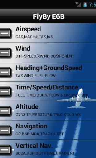
FlyBy E6B
FlyBy E6B is an essential flight computer application for all pilots. Designed by a professional airline pilot it includes many features not found in other E6B programs.
Always improving: FlyBy E6B was one of the very first applications of its kind published for the Palm OS. Used by thousands of pilots the world over, it has evolved from the suggestions and feedback we have received.
FlyBy E6B Features:
Airspeed Calculations:
- True Airspeed using Calibrated Airspeed
- True Airspeed using Mach#
- Calibrated Airspeed using TAS
- IAS Using MACH#
- Equivalent Airspeed using CAS
- Mach# Using TAS
- Mach Crossover Altitude
- Planned MACH#
- Planned TAS
Wind Calculation:
- Find Wind Direction and Speed
- Find Wind Component (headwind and crosswind)
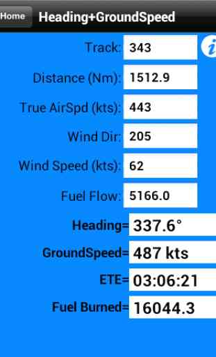
Heading and Ground Speed:
- Find Heading, Ground Speed, ETE and Fuel Burned
Compass Heading:
- Find Compass Heading using True Heading, Magnetic Variation and Deviation
Time-Speed-Distance:
- Find Estimated Time Enroute
- Find Ground Speed
- Find Distance
- Find Fuel Time
- Find Fuel Flow
- Find Fuel Burned
- Find Estimated Time of Arrival
- Fixed GroundSpeed (Find required TAS given a Track, Groundspeed, and wind)
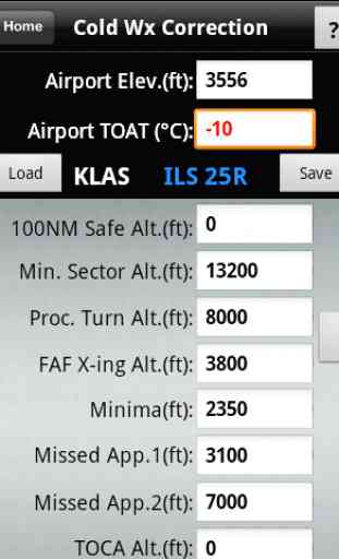
Altitude Calculations:
- Density Altitude
- Pressure Altitude
- True Altitude
- Cold Temperature Approach Altitude Correction
Vertical Navigation Calculations:
- Distance and Time using Altitude Change, Ground Speed, Vertical Speed
- Rate of Descent using Altitude Change, Ground Speed, Distance
- Rate of Descent using Altitude Change, Ground Speed, Descent Angle
- Feet/Nm using Vertical Speed, Ground Speed
- Feet/Nm (%) using Gradient %, Ground Speed
- Rate of Climb using Required Climb Gradient and Ground Speed
- SCDA (Constant Descent Angle)
- VDP (Visual Descent Point)
- VPA (Vertical Path Angle) Deviation
Navigation Calculations:
- Critical Point
- Point of No Return
- Time to Minimum Descent Altitude
- Navigation Track and Distance between two points with plotted map view
- Rate One Turn
- Radius of Turn
- Turning Stall Speed
- DME Arc
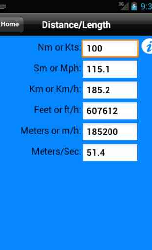
Conversions:
- Distance: Nautical Miles/ Knots Statute Miles/ Mph Kilometers/ Kph Feet Meters Meters/Second Feet/Second
- Volume: US Gallons Imperial Gallons Liters
- Temperature: Celsius Fahrenheit
- Weight: Pounds Kilograms
- Altimeter: Inches Hg Millibars/Hectopascals mmHg
- Fuel, Temperature Corrected, JetA, JetB, AvGas: US Gallons Imperial Gallons Liters Pounds Kilograms
- QFE/QNH airfield altitude conversion
- DMS/D-M.m/DM.m and D.d coordinate conversion
- VNAVGradient %Feet per NMAngle
Weather:
- Relative Humidity, Heat Index, Cumulus cloud base, Wind Chill
- NOAA METAR and TAF aviation weather access
Other Functions:
- Linear Interpolation
- Minimum Floor Load Limit (Cargo)
- Maximum Cargo Weight
- Runway Slope
- Sunrise/Sunset plus sun Azimuth and Elevation
Category : Maps & Navigation
Reviews (10)
I have been using your FlyBy Windows XP e6b and Nav.Pro for more than 10 years and was never disappointed.I do not think that this version will either.And I am impressed
All of the functions included work well. However it should have a weight and balance calculator since this is an essential element of any flight planning.
its easy to use and all flight function whith discripe for eache one is availabel
Easy to use excellent app. Great for calc CANPA
Simple yet full of features.
A great little App which I have used for over 10 years. This Android version works just as well as the previous versions. Well worth the price.
I love this app for the Stabilized Constant Descent Angle program and the cold weather corrections. It makes it quick and easy when you are busy and need things done promptly. The great circle moving map is usefull too as aircraft software does not show States lines or Provinces or geographical points. Worth buying.
Been using Skywriter products since I had my Windows 6.0 phone. Its reliable, easy to navigate, and even easier to read on smaller screens. I've trialed other apps, but have since deleted them and will continue to purchase from this company. Well done Skywriter, looking forward to future products from you.
The cold wx calculator alone is worth every penny. Well done!
This is the best I've run across. Well worth it.