Flyover Country - trip map
- discover the world below with offline maps and POI.
**GPS functionality is only possible from the window seat and GPS reception quality varies by device/conditions**
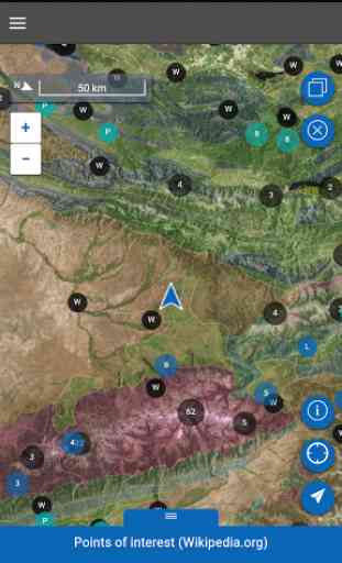
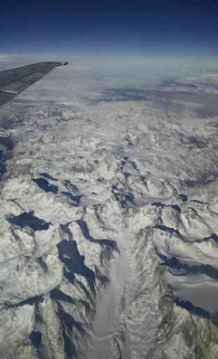
Learn about the world along the path of your flight, hike, or road trip with GPS tracking. Offline geologic maps and interactive points of interest reveal the locations of fossils and georeferenced Wikipedia articles visible from your airplane window seat, road trip, or hiking trail vista.
Follow Flyover Country for updates and photos from the sky!https://www.facebook.com/flyovercountryapp/https://twitter.com/flyovergeohttps://www.instagram.com/flyovergeo/
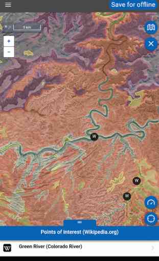
Flyover Country is a National Science Foundation funded offline mobile app for geoscience outreach and data discovery. The app exposes interactive geologic maps from Macrostrat.org, fossil localities from Neotomadb.org and Paleobiodb.org, Wikipedia articles, offline base maps, and the user’s current GPS determined location, altitude, speed, and heading. The app analyzes a given flight path and caches relevant map data and points of interest (POI), and displays these data during the flight, without in flight wifi. By downloading only the data relevant to a particular flightpath, cache sizes remain reasonable, allowing for a robust experience without an internet connection.
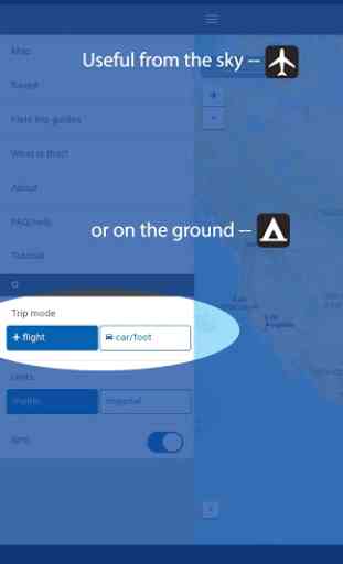
Flyover Country is not limited to the window seat of airplanes. It is also ideal for road trips, hiking, and other outdoor activities such as field trips and geologic field work.
How to use FC:-Tap two or more points on the map to specify your path, then click 'Load path' in the top right corner to view the data associated with the path. Select 'Save for offline' to store the data and associated articles on your device for offline use. Access saved paths from the 'Saved' menu. -Toggle 'GPS' to the on position in the side menu (accessed by pressing the menu button, top left). This will enable position tracking, speed, heading, and altitude information to be accessed from the map view.-You may also select your 'Trip mode' from the side menu. the 'plane' provides a wide strip of data while 'car/foot' provides a narrower but more detailed geologic map with detailed unit descriptions and metadata.
Known issues and future features: -Fossil silhouette icons are not yet stored offline. -Wiki article images are not yet stored offline-Plot breadcrumbs of flight path trajectory during flight-More data! If you have a data source suggestion email Shane at [email protected]
Category : Travel & Local
Reviews (26)
I would like to see what lakes and roads are out my window. And yes I've made sure I've downloaded everything for my flight path. It's great that it's free, but I would pay for a better app as I love to look out the window when I fly. A small example is I flew by Great Sands National park. No mention on the app.
This great when flying. It would be great to have the option to add and remove information from the maps while they are running. Sometimes the info markers obscure the map. It would be good to have more place names. The available information on natural features is great.
App works fine on my Galaxy S8 but when I try to save a path on my Galaxy Tab S2 I get told there is something wrong with the file system. None of my other apps have a problem. Would be nice to be able to use this on the bigger screen of the tablet.
Works really well. Get a window seat! Wish it was a little more clearer but maybe I have to tweak the settings. But the GPS and speed works great and its easy to tell where you are flying over.
I fly for a living. Using this app is exciting to know the fossil history and other historic facts of the cities you're flying over. It would be great if the app was able to connect through airline free wifi as well.
Great Experience. But you have to consider the GPS recognition depends on the plane and your seat. If you choose a window seat you will agree. You also have to check which information you would really like to follow on your route.
As someone who loves looking out the window during air travel, this app is fantastic. Make sure to put your flight path in and download it for best experience.
Wish there was an app like this that showed more surface features as well as geologic ones. It's cool to know the bedrock, fossils, and some natural features, but I'd love to also know what city I'm over or what that lake or river is. You really need to be a geology nerd to enjoy this app.
I absolutely love this app! I am a geologist, so naturally I have always spent every flight staring out the window, curious about the geology and geography below me. This app provides so much information and keeps me entertained during every flight!
Great way to learn as you fly or drive or take a train. Also love the clouds information. Just wish you could draw your path a little easier - undo functionality.
I installed and opened the app and I was presented with a map that continually jumped around without ever coming to rest. I said to myself, 'self, this thing is such a mess.'
A great concept and just what I'd been looking for, but sadly had problems connecting to mock GPS (and the phone won't pick up GPS by itself in-flight), so effectively unusable.
Really useful app. Although while trying to download route I am pretty often getting error mesaage: Requests failed. Please check your internet connection" my internet works just fine. Would give 5 stars if not that issue.
This app is easy to use, and helps make my flights more enjoyable and educational. I really appreciate the beautiful formations I see out the window, and this app helps me learn more about this unique planet!
Excellent App. Shows all interesting places/landmarks enroute. Very educational. Makes me feels like I have an IQ of 180.
Fun app!! I fly twice a week, always wondering what's below, this is great, show my speed, altitude and fun facts about everything below. Just make sure you map your flight first and enjoy some facts from 30,000 ft up!
This app is great. My only quibble is that the downloads are very slow. You have to remember to get the maps well before you fly.
In an airplane, the oblique view would be better if it was from the perspective of a passenger. All else is fabulous!
refuses to download maps. gets to 80-90% then freezes. tried 10 times on 4g and wifi. app was open the whole time.
When able to pick up GPS it works pretty good, unfortunately on about half the flights the GPS signal is never acquired or is lost in mid flight.
I love Flyover Country. It answers questions I always have like, "what town is that?" and "what is that lake?" Its amazingly informative and the link to articles alows me to learn a lot.
Very very good app. No doubt about that!Maybe I missed it, but there should be a feature to log the entire flight path readings. Thanks!
Easy to use and a great tool for rock enthusiasts. It's really cool to get to see the types of rocks and fossils along a trip.
Failed to display air speed at times. Should have shown 595mph, but said 0mph. Be nice to download higher resolution maps.
I'm a geologist and this app is pretty good, but I'd like to see a greater variety of base maps and aerial images.
I use this when driving, hiking, and flying. I love following the geology of an area at such a fine scale, as each hill can have a different origin here in western Oregon. Seeing all the faults is exciting in terms of understanding the topography of the terrain. The developers were very friendly and helpful when I was having issues loading the software in early 2018.