Free Gps For Boat fishing
Be careful after the application is installed and the map appears, close and reopen the application to work properly. This app is for testing only if you can download it (Gps Boat Car Navigation) It's faster, ad-free, with more tools ...
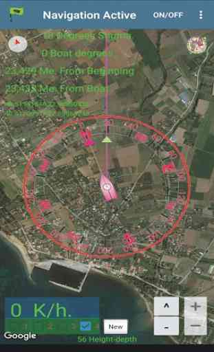
Maps: Satellite, Simple, Terrain, OpenStreetMap, Seamap, OpenTopo
This GPS is specifically targeted at amateur fishermen
but that doesn't mean it might not be a useful tool for the car ..)
was designed specifically for the sea with an environment identical to the sea-going GPS
Easy orientation and navigation to the mark.
Look for the location and then find the nearest or the best route you want to take,
when the route is displayed you will see the distance and time it will take you to reach your destination
Traffic mode you can see live where there are traffic jams, and pick another one
route ...
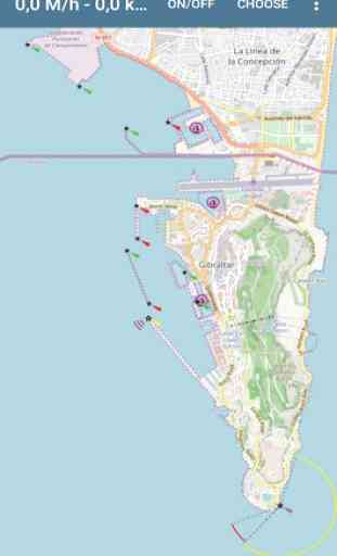
Explore the harbor sites, navigate safely and go the right way
find anchorages and more
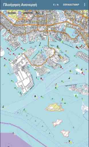
Streetmap maps also work offline, as each location that is opened at the same time is stored
in the phone memory in the folder (osmdroid), you will notice that the first time is delayed expired according to the speed
of the network, this means that as we process more sites, more bits are stored in the phone memory.
If you see multiple locations and you have space on your phone you can delete the folder (osmdroid) so it will start
from the beginning (note that removing the application (osmdroid) does not delete you should find it and delete it if you do not want it).
four storage directories
where you can store as many spots as you like
You can plan the next routes by finding spots on the map by storing
in a list in the order you want them to be ready to use them.
In StreetMap you can plan routes and save ...
If you check Trace you can save it at the end of the route ....
Scheduled paths and route track can be extracted into files (GpsFile / Name.TXT - .csv)
Four trail memories to know how expensive you went to and help you bang one
party without leaving gaps or passing through the same spot
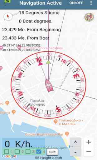
1) Position azimuth from where you come from
2) Directional azimuth to get to the stigma
3) Kilometers or miles from the beginning to the point we are going
4) Kilometers or miles from where you are to the point you are going
5) Speed in kilometers or miles per hour
6) Co-ordinated by the stigma we are going for
7) Coordinates from where you are
8) Distance measurement in three different ways
9) Altitude measurement
10) Permanent Track Tracks
two more pages available with the lists to choose from
and a page for saving will also find one
help page.
They are simple to handle so they can use it
with ease all ..
Maps: Satellite, Simple, Terrain, OpenStreetMap, Seamap, OpenTopo
This GPS is specifically targeted at amateur fishermen
but that doesn't mean it might not be a useful tool for the car ..)
was designed specifically for the sea with an environment identical to the sea-going GPS
Easy orientation and navigation to the mark.
Look for the location and then find the nearest or the best route you want to take,
when the route is displayed you will see the distance and time it will take you to reach your destination
Traffic mode you can see live where there are traffic jams, and pick another one
route ...
Explore the harbor sites, navigate safely and go the right way
find anchorages and more
Streetmap maps also work offline, as each location that is opened at the same time is stored
in the phone memory in the folder (osmdroid), you will notice that the first time is delayed expired according to the speed
of the network, this means that as we process more sites, more bits are stored in the phone memory.
If you see multiple locations and you have space on your phone you can delete the folder (osmdroid) so it will start
from the beginning (note that removing the application (osmdroid) does not delete you should find it and delete it if you do not want it).
four storage directories
where you can store as many spots as you like
You can plan the next routes by finding spots on the map by storing
in a list in the order you want them to be ready to use them.
In StreetMap you can plan routes and save ...
If you check Trace you can save it at the end of the route ....
Scheduled paths and route track can be extracted into files (GpsFile / Name.TXT - .csv)
Four trail memories to know how expensive you went to and help you bang one
party without leaving gaps or passing through the same spot
1) Position azimuth from where you come from
2) Directional azimuth to get to the stigma
3) Kilometers or miles from the beginning to the point we are going
4) Kilometers or miles from where you are to the point you are going
5) Speed in kilometers or miles per hour
6) Co-ordinated by the stigma we are going for
7) Coordinates from where you are
8) Distance measurement in three different ways
9) Altitude measurement
10) Permanent Track Tracks
two more pages available with the lists to choose from
and a page for saving will also find one
help page.
They are simple to handle so they can use it
with ease all ..
Category : Maps & Navigation
Related searches
Reviews (5)
Joh. N.
Aug 20, 2020
Right from the beginning this thing crashes!
Cha. B.
Jan 5, 2020
It is working perfectly
Naj.
Aug 8, 2020
This super and very intelligent app
Jes. a. D.
Dec 8, 2019
..i realy got learn...
Useless app map cant be kept on northup mode. T