Free Nautical Charts
FREE NAVIGATIONAL CHARTS
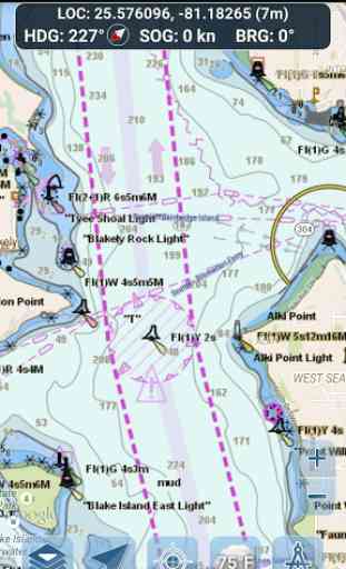
- NOAA ENC Electronic Navigational Charts (NOAA's newest and most powerful electronic charting product)
- NOAA BSB Classic Raster Charts (including Day, Red, Dusk, Night, and Gray versions)
- All chart data is supplied by NOAA.
Just toggle the chart you want in the map settings section and it will show up on the map! Zoom in for the finest detail!
ROUTE PLANNING TOOLS
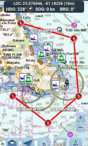
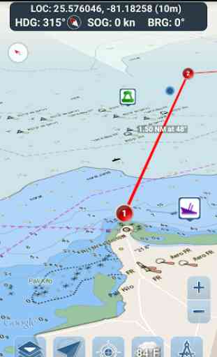
-Route Plotting. Tap and hold on the map for one second to plot your waypoints. To form a route, continue to tap and hold on the map in different areas. Distance and bearing are conveniently calculated and displayed for each leg as you add, adjust, or remove waypoints.
-Travel Mode. Automatically centers the map on your current position as you move. Use travel mode to see how closely you are following your plotted route in real time!
-Route Leg Summary. A convenient view containing detailed information of each leg you have plotted, including start and end coordinates, distance, and bearing.
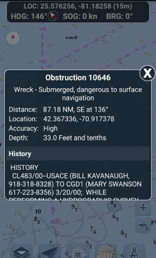
BUOY REPORTS AND OBSTRUCTION INFORMATION
Markers for buoys and obstructions are conveniently plotted in their actual location on the map! Just click on the marker to view their information!
- Buoy Reports: Get complete current conditions and wave reports for fixed and drifting buoys.
- Obstructions: Get location and history information about potentially dangerous, submerged hazards including rocks and sunken vessels.
NAVIGATION DASHBOARD
The navigational dashboard shows various real-time information including:
- Current location (latitude and longitude, with accuracy range)
- Current Heading (includes a small directional compass as well!)
- Current Speed Over Ground
- Current Bearing
MARINE MAP OVERLAYS
Toggle various marine overlay data right onto the map to get a better idea of the current boating conditions!
Overlays include:
- Water Surface Temperature (Global)
- Wind Speeds (US only)
- Wind Gusts (US only)
- Wave Heights (US only)
LOCATION SHARING OVER WATER / VIEW OTHER BOATS
- Display your last known location, speed, bearing, and boat name on the map for other Marine Ways boaters to view.
- View the last known location, speed, bearing, and boat name of other Marine Ways boaters, as well as their distance and bearing from your location.
- Location sharing is turned off by default. When you are ready to share, toggle it on within general settings. To continuously update your location on the map, keep the app opened and focused. The app currently does not update your location in the background.
WEATHER INFORMATION
- Weather Precipitation Radar (US & Hawaii only). Detects any rain and snow in the area.
- Weather Station. Reports the nearest observation station data. Current temperature, humidity, weather conditions, wind, and more! Station observation data is available globally.
- Weather Alerts. Weather station also reports any active weather alerts issued by the National Weather Service such as severe thunderstorm warnings or hurricane warnings. Weather alert information is available for US, Alaska and Hawaii.
- Land Surface Temperature overlay. Shows the current surface temperature on land (US only).
Before using this application, please read and agree to the following terms of use / service and privacy policy:Terms of Use / Service: http://www.marineways.com/apptermsPrivacy policy: http://www.marineways.com/appprivacy
Navigational Charts Disclaimer from NOAA:
NOAA ENC Online is not certified for navigation. Screen captures of the ENCs displayed here do NOT fulfill chart carriage requirements for regulated commercial vessels under Titles 33 and 46 of the Code of Federal Regulations.
Enjoy the app! Marine Ways is also available on the web at http://www.marineways.com
Category : Travel & Local
Reviews (25)
Seems straight forward and works well. 2 things to make it better. 1) offer a paid / no ad version as the used space at top is annoying and it would be useful to display more of the chart. 2) and most importantly, need a way to save multiple plotted charts. Currently can only plot one at a time and then need to remove waypoints before plotting a new chart. Thanks
Works like any good chart plotter. Easy to use. Haven't used on the water but should be a good backup. Update: 7/31/21. Deleted awhile back because of memory. Reinstalled. Still the best free gps I've used. Very accurate and informative. Almost to much info. in places, just zoom out to separate icons. Will keep as a backup and to plot next day trips.
good app. wish there was a paid ad free version. also wish you could download the charts so they don't have to load everytime. the app really should work offline, as many places we navigate have little to no cell service. other than that it's solid. charts change as you move in and out, cool overlays and plenty of features.
This app shows water depths mostly for large bodies of water. None of the inland lakes that I visit show water depths and these lakes are not small. Instead, it is just like looking at google maps. If I wanted to do that, then I would have used google maps! That is too bad because this app seemed good. It doesn't ask for too many permissions. But when I want to see a chart for a body of water, then I better be on a major water way.
This is fantastic. I use it all the time in Chesapeake Bay. Used it recently in the Caribbean. The level of detail is excellent. I have a Simrad GPS fishfinder combo, and the charts and features in this app are superior. Indeed, I do not bother with the chartploter and just use this app for navigation.
This app could be a great app. The routing is all manual, the buoys rarely show the information as far as wave height and or correct weather. During tropical storm and currently need river levels and it show that the blue indicator for the river on land. Also has a brown overlay on the ENC Portion that limits the ability to enhance the transparency on the rivers as it covers up the land and water lines. Only goes inland for ? For a few miles and rivers that connect to ocean not fully covered.
No way to get the app to lock onto North up. Always wants to be course up but the map doesn't follow orientation, which makes the map upside down when heading south. If this bug was there, would rate 4 or 5.
Great app, though wholly dependant on having a cell signal which is why I only use it on my little boat. Only real complaint I have is that the ads (expected of course, the app is free) actually cover the usable portions of the chart and get in the way.
Have not really tried any other marine nav apps, as I guess I lucked out with this one on the 1st try. Combines charts with GPS & has minimal ads. Restored a small power boat this year and this app has completely transformed naviagting a small craft on Long Island Sound, compared to when I was younger. It's google maps @ sea, won't leave the dock with out it.
It is a great backup and supplement to my boat's chart plotter when in water that I am unfamiliar with. I also use it to help me plan future coastal boating trips. I still prefer to use my boats chart plotter while underway as this app doesn't work without cell coverage, but it is still a great resource to have!
Zooming in and out let's me see the lakes I would like detail on. But once done, they are covered and appear not to exist at all. The largest lake in the state is covered, so is Lake Michigan. But the smaller lakes are not. Free Bathymetry maps are available for these lakes, im just looking for an app based map, not browser. This app appears to have a lot of features, but I can't use them. Uninstalled.
Since I'm mostly a recreational day sailor, near mobile networks on the coast, i find myself using this app on and off the boat constantly. I rarely pull out the paper charts unless I see something I don't recognize on the app. Usually, it's because I need to update the printed chart with new details.
I use professional and high end expensive equipment at work and compared to it this app is great! I work on boats and navigate on a daily basis and I highly recommend this app to any boater whether you're a weekend boater or a regular on the water. This system is very good to have and could save your life and save you a ton of money!
BEST APP PERIOD. Water Depths are large and clear. Obstructions and Wrecks are clickable and have lots of detail. You can do a Satellite Overview. Ads are only on a small portion of the top of the screen. BUT I wish I could buy the app and not have any ads.
Love it. The accuracy is great. Clean and clear on the screen just like a plotter. Good job. The price is nice, free. Don't mind ads. Short inconvenience. As of today, nothing has changed, the app is terrific as usual. Keep up the great job on your "Marine Ways". Thank You.
Great and free! Does what it claims... is a great pocket plotter for the casual boater. I'd like to be able to save multiple routes, and to convert the electronic chart to feet. Other conversions might be nice (NM to KM or Stat Miles, perhaps.)
Nice presentation. Works well, but not for me because it appears that depths can only displayed in meters. It can only display charts when you have a good data connection. But that's fine for the occasional user.
Junk... I'm on a cruise and it says that I'm in Tampa Bay. Actually I'm about 150 to 200 miles from there. So this is not even close to accurate. I'm sitting on the very top of the ship also with only stars above me. No roof or anything to interfere with the GPS. Not even a cloud in the sky. Samsung Galaxy Note 9. I've also closed the app and restarted it several times and it keeps saying the same garbage.
Turns your phone into a marine GPS. Puts you right on the NOAA charts. It's not pinpoint accurate, but close enough so you can figure out changes in depths. I've been using it for a few years now and LOVE IT!!!
I like to kayak and its great for mapping out routes. I live in puerto rico and usually just island hop(which is usually only a few miles) but it works for me so that is why i give it 5 stars. I honestly can not speak for people with ships.
Very helpful app. Love the ability to combine layers. Want to be able to download maps/charts and it is hard to get data in the middle of the Chesapeake Bay.... Great app though.
Very accurate GPS overlay. When a depth guage failed, the app allowed me to safely naigate a shallow & narrow channel. After feedback with creator, I learned it will soon deserve a 5th star with the ability to store waypoints and charts allowing you to navigate without constant cell phone service.
Dont pick another app for charting at home. This is hands down the best charting/navigation app for personal ease of use. Being in the maritime industry it's nothing compared to commercial use of course but for home and fishing and rough charting at work you cant beat this app! 5 starts, high five, good star and everything else!!! I may even put some stickers on my toys!
App stops running after just a minute and closes itself. App has good detail but is useless since you can't keep it running. Would hate to try to use it in real life and need info on depth of water and end up grounded
Reliable and accurate! I've used this for app for little over a year now on my sailboat and many times at night just to navigate through the Lower Columbia River and Multnohmah Channel and always I'm riding right along the Waypoint lines that I created. I was very impressed the first time I ever used it and I could tell right away that it was a keeper. I've downloaded and deleted several other apps before I found this one. Lack of offline maps and features is my only complaint.