FREE VFR Flight Planner-Timer
This application is ALL YOU NEED for planning and VFR flying using checkpoints (NO INTERNET CONNECTION IS NEEDED):
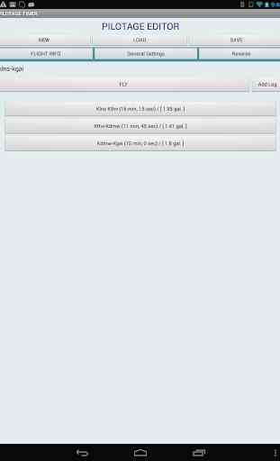
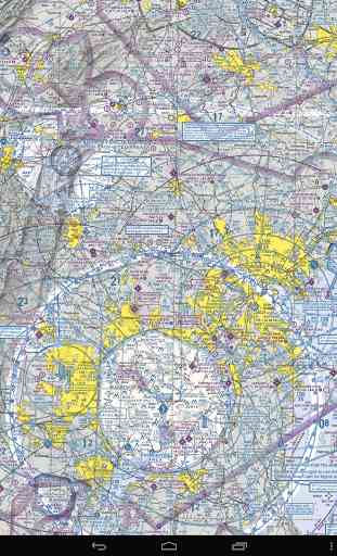
1. Using sectional you create your flight plan, identify your checkpoints (you need to know two things from sectional: true course, distance and TAS);
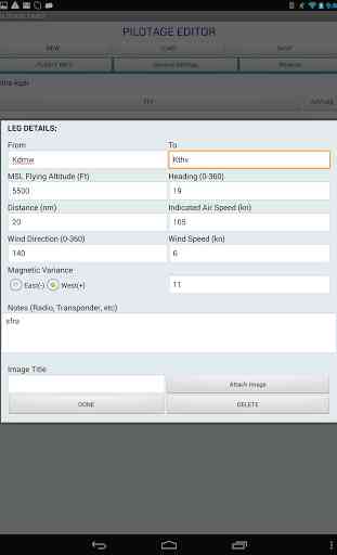
2. Each checkpoints can be customized (MSL altitude, indicated airspeed, wind direction, wind speed, magnetic variance, checkpoint specific images, notes to write radio frequencies); some of the fields automatically populated for your convenience.
3. Once checkpoint initial data is created this app will calculate (just like E6B flight computer) your ground speed (kn/hr and kn/min
- used for descends), true heading, magnetic heading, fuel consumption, ground speed, time enroute, and even distance to horizon from the altitude you fly. You can add notes/reminders (radio frequencies, transponder codes, etc) and images specific to your checkpoint.
4. Once your flight plan is in place you can save it to SD card on your device and adjust it to a specific weather condition just right before you take off next time
- no massive recalculation needed
- all numbers will be updated by this application for you in a few seconds.
5. You can load your flight plans from SD card at any time, whenever you fly. Simply update wind conditions to recalculate your flight data before you take off.
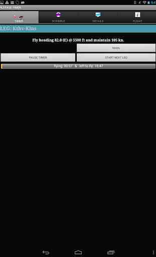
6. Get in a plane and click "FLY" to activate your timer. Timer is visually shows you time you are flying the leg and time you have left to fly.
7. While flying you will be able to use a built in scribble
- no more paper/pencil in the plane. Take notes on your device with your finger.
9. You can use sectional/airport images you attached to each checkpoint
- no more HUGE paper sectional. Zoom it in/out with simple two finger swipe or double click on the screen.
10. You will be able to see the progress of the timer for each checkpoint! If you reach a checkpoint earlier/later than it was planned you can adjust your flight data.
This application is not using internet connection, GPS or any other heavy battery consuming features. Recommended to be used on bigger screen phones and tablets.
This application is especially convenient for night time flying
- no flashlight needed to see details of your flight plan. It will run for hours on your android device, even with a very bright screen.
The ability to pause the timer or start next checkpoint comes handy when the winds change while en-route and you may arrive to the next checkpoint sooner or later then expected.
I developed this application for my personal use, tested it at night and day time flying
- pretty accurate in calculations and I find it reliable and very convenient.
With this application you will save time planning/calculating your flight. I do recommend to try this application and get a full version. You will find really "Reverse" route calculation.
1. Using sectional you create your flight plan, identify your checkpoints (you need to know two things from sectional: true course, distance and TAS);
2. Each checkpoints can be customized (MSL altitude, indicated airspeed, wind direction, wind speed, magnetic variance, checkpoint specific images, notes to write radio frequencies); some of the fields automatically populated for your convenience.
3. Once checkpoint initial data is created this app will calculate (just like E6B flight computer) your ground speed (kn/hr and kn/min
- used for descends), true heading, magnetic heading, fuel consumption, ground speed, time enroute, and even distance to horizon from the altitude you fly. You can add notes/reminders (radio frequencies, transponder codes, etc) and images specific to your checkpoint.
4. Once your flight plan is in place you can save it to SD card on your device and adjust it to a specific weather condition just right before you take off next time
- no massive recalculation needed
- all numbers will be updated by this application for you in a few seconds.
5. You can load your flight plans from SD card at any time, whenever you fly. Simply update wind conditions to recalculate your flight data before you take off.
6. Get in a plane and click "FLY" to activate your timer. Timer is visually shows you time you are flying the leg and time you have left to fly.
7. While flying you will be able to use a built in scribble
- no more paper/pencil in the plane. Take notes on your device with your finger.
9. You can use sectional/airport images you attached to each checkpoint
- no more HUGE paper sectional. Zoom it in/out with simple two finger swipe or double click on the screen.
10. You will be able to see the progress of the timer for each checkpoint! If you reach a checkpoint earlier/later than it was planned you can adjust your flight data.
This application is not using internet connection, GPS or any other heavy battery consuming features. Recommended to be used on bigger screen phones and tablets.
This application is especially convenient for night time flying
- no flashlight needed to see details of your flight plan. It will run for hours on your android device, even with a very bright screen.
The ability to pause the timer or start next checkpoint comes handy when the winds change while en-route and you may arrive to the next checkpoint sooner or later then expected.
I developed this application for my personal use, tested it at night and day time flying
- pretty accurate in calculations and I find it reliable and very convenient.
With this application you will save time planning/calculating your flight. I do recommend to try this application and get a full version. You will find really "Reverse" route calculation.
Category : Maps & Navigation
Related searches
Reviews (3)
A. G. u.
Jul 22, 2012
Great idea. I reported that it fc on startup. Hope to update the app and rating soon. No developer support. Uninstalling.
Ric. N.
Jun 16, 2014
The wind correction is way off the mark! I entered a leg with true course, wind speed and direction and flew it on Flight Simulator. Not even close to the destination. Ran the same figures with my E6B and got a course that was different by about 15 degrees! I flew that in the simulator and hit the destination right on. Otherwise, it would be a good app to have.
Not tried the app in flight but just trying it, it is such a shame there are no options for conversions i.e. gallons to litres or knots to MPH