
FSWidgets EFB-HD
FSWidgets EFB comes to Android!
EFB-HD for Android is an Electronic Flight Bag for use with FSX, FS2004 and X-Plane 9/10.
**
* DEMO **
* DEMO **
* DEMO ***This is a DEMO VERSION, limited to 15 minutes use at a time around the San Francisco Bay area only. Restart the app for as many 15 minute periods as you wish.
Please visit our website for further product details, support and purchase.
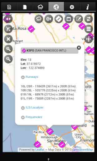
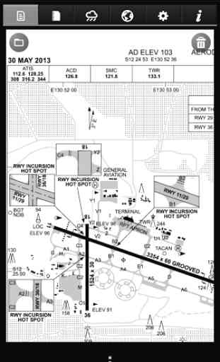
Your EFB is completely configurable enabling the simulator pilot to add or remove approach plates, charts, manuals, flight plans and weather image links. In addition it comes equipped with a rich Moving Map module supporting FSX, FS2004 and X-Plane flight plan formats.
EFB-HD has been designed to support most screen sizes and resolutions. We strongly recommend tablet sized devices to ensure the best user experience, particularly when interacting with aircraft approach plates and checklists.
* Display of Approach Plates or Charts in these supported formats:
- Adobe PDF (.pdf)
- PNG Image (.png)
- JPG Image (.jpg)
- BMP Image (.bmp) supported but not recommended
- GIF Image (.gif) supported but not recommended
* Display of Manuals or Guides in these supported formats:
- Adobe PDF (.pdf)
- PNG Image (.png)
- JPG Image (.jpg)
- BMP Image (.bmp) supported but not recommended
- GIF Image (.gif) supported but not recommended
* Rich Text Format (.rtf)
* HTML Format (.html)
* Plain Text (.txt)
* PDF is enabled via FSWidgets internal PDF rendering engine, no external or 3rd party "Reader" required
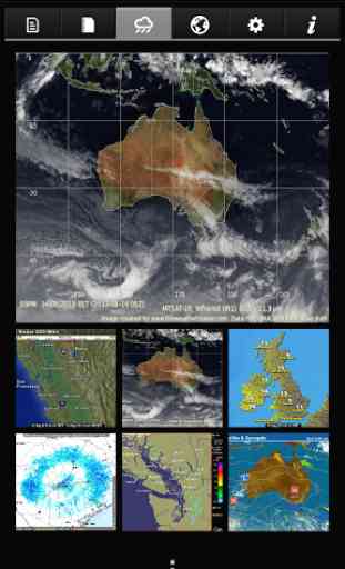
* Display online WX (Weather) Images (e.g. doppler radar, cloud cover, satellite, etc.).
* Moving Map connects to FSX, FS2004 & X-Plane 9/10.
* Moving Map supports FSWidgets CLOUD BASED AERO CHART products.
* Flight Plan Display
- supports native FSX, FS2004 and X-Plane flight plan files.
* Waypoints can be tapped to reveal the related data (e.g. lat, lon, ident).
* Direct-To feature and Nearest Airports search.
* FSWidgets NETWORK PACK provided free.
* Map powered by CloudMade map rendering API (using OpenStreetMap data).
* Connect & disconnect from the flight simulator as required.
EFB-HD for Android is an Electronic Flight Bag for use with FSX, FS2004 and X-Plane 9/10.
**
* DEMO **
* DEMO **
* DEMO ***This is a DEMO VERSION, limited to 15 minutes use at a time around the San Francisco Bay area only. Restart the app for as many 15 minute periods as you wish.
Please visit our website for further product details, support and purchase.
Your EFB is completely configurable enabling the simulator pilot to add or remove approach plates, charts, manuals, flight plans and weather image links. In addition it comes equipped with a rich Moving Map module supporting FSX, FS2004 and X-Plane flight plan formats.
EFB-HD has been designed to support most screen sizes and resolutions. We strongly recommend tablet sized devices to ensure the best user experience, particularly when interacting with aircraft approach plates and checklists.
* Display of Approach Plates or Charts in these supported formats:
- Adobe PDF (.pdf)
- PNG Image (.png)
- JPG Image (.jpg)
- BMP Image (.bmp) supported but not recommended
- GIF Image (.gif) supported but not recommended
* Display of Manuals or Guides in these supported formats:
- Adobe PDF (.pdf)
- PNG Image (.png)
- JPG Image (.jpg)
- BMP Image (.bmp) supported but not recommended
- GIF Image (.gif) supported but not recommended
* Rich Text Format (.rtf)
* HTML Format (.html)
* Plain Text (.txt)
* PDF is enabled via FSWidgets internal PDF rendering engine, no external or 3rd party "Reader" required
* Display online WX (Weather) Images (e.g. doppler radar, cloud cover, satellite, etc.).
* Moving Map connects to FSX, FS2004 & X-Plane 9/10.
* Moving Map supports FSWidgets CLOUD BASED AERO CHART products.
* Flight Plan Display
- supports native FSX, FS2004 and X-Plane flight plan files.
* Waypoints can be tapped to reveal the related data (e.g. lat, lon, ident).
* Direct-To feature and Nearest Airports search.
* FSWidgets NETWORK PACK provided free.
* Map powered by CloudMade map rendering API (using OpenStreetMap data).
* Connect & disconnect from the flight simulator as required.
Category : Casual
Related searches
Reviews (4)
A. G. u.
Oct 18, 2015
good, one program for charts, manuals etc. Suggestions, VATSIM connevctivity
A. G. u.
Aug 8, 2014
This is a serious EFB for flight sim/x-plane, not a game for kids.
A. G. u.
Feb 21, 2014
Do not get this app I thaught it would be a game it's just a rubbish map!
The developer doesn't appear interested in updating, improving or fixing their software. This has now been bettered by similar apps by other developers.