

FSWidgets QuickPlan
FSWidgets QuickPlan is a visual touch enabled flight planner that makes it easy to generate flight plans in native FSX, FS2004 or X-Plane formats.
For the folk commenting saying they didn't know it was a DEMO, we don't know how to make this any clearer. This is a DEMO only, the full version can be purchased from our site.
**
* Please note, this is a DEMO VERSION ONLY ***
Demo is limited to the San Francisco (KSFO) region only, it is fully functional but will operate only in that region. For purchase details please visit our site and our store at http://fswidgets.com. We provide this demo to give you the opportunity to test QuickPlan and ensure you are happy with its features. Should you decide to purchase, you will receive a key that will unlock the demo version.
The entire route is generated visually, by tapping the map to add the departure airport, intermediate waypoints and arrival airport in the same order that you intend flying the plan.
Flight plans are saved and loaded using the SD card on the phone or tablet. Plans can be exported using any normal file browser on the Android device or by using standard Windows or Mac file management tools.
QuickPlan utilises a new mapping engine and includes 12 world-wide map styles and has support for FSWidgets Cloud Based Aero Chart products (free Cuba/Puerto Rico WAC Cloud Based Chart included) and the FSWidgets Cloud Based World Nav Data product (Free KSFO
- San Francisco Bay area Nav Data included).
Main Features:
Supports tablets, hi-resolution phones, standard and low-end screens and devicesGenerates native FSX (.pln), FS2004 (.pln) and X-Plane (.fms) format flight plansSaves flight plans to the SD card, can be exported/importedFlight plans can be exported via USB connection or SD cardTerrain profile display using the FSWidgets terrain engineSearch for airport by ICAO identifierMap powered by CloudMade Leaflet API (using OpenStreetMap data)Includes 14 world-wide maps stylesSupports FSWidgets Cloud Based Aero ChartsFree Cuba/Puerto Rico WAC Cloud Based Chart includedSupports FSWidgets Cloud Based World Nav DataFree KSFO (San Francisco Bay) area Nav Data includedWorld-wide Metar and TAF Data iconsUS Nexrad (Next-Gen Radar) Data
QuickPlan can be used in Freeform Mode, Advanced Mode, or a combination of both:
Freeform Mode:
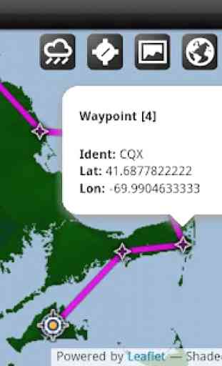
Simply tap anywhere on the map and QuickPlan will allow you to add it as a generic waypoint. VFR pilots often use towns, lakes and other unique geographic features and with QuickPlan you can add any geographical location shown on the base map. Plans created this way label the waypoints automatically with generic names (e.g. DEP, WP1, WP2, ARR).
If desired, the entire route from departure to arrival can be created without reference to any navigational aids or official airports. This is handy for bush pilots who often use unlicensed airfields and small landing strips (or seaplane landing areas). Helicopter pilots can also quickly create plans that depart from off-airport locations like building rooftops or land on a road.
Advanced Mode:
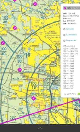
If you own the FSWidgets Cloud Based World Nav Data product you can create more advanced flight plans by tapping on any of the icons displayed on the map to add them as waypoints
- airports, VOR's, NDB's and intersections (data for the KSFO area is included free). Plans created this way label the waypoints automatically with airport and navigational aid identifiers taken from the Nav Data (e.g. KSFO, OSI, LV, FABLA).
Who we are:
FSWidgets is a software development team based in Australia, specializing in add-ons for Microsoft Flight Simulator (Windows) and Laminar Research X-Plane (Windows, Mac, Linux). Both of its founding members have extensive experience in creating award-winning add-ons for flight simulators and have been active in the simming community for well over a decade.
For the folk commenting saying they didn't know it was a DEMO, we don't know how to make this any clearer. This is a DEMO only, the full version can be purchased from our site.
**
* Please note, this is a DEMO VERSION ONLY ***
Demo is limited to the San Francisco (KSFO) region only, it is fully functional but will operate only in that region. For purchase details please visit our site and our store at http://fswidgets.com. We provide this demo to give you the opportunity to test QuickPlan and ensure you are happy with its features. Should you decide to purchase, you will receive a key that will unlock the demo version.
The entire route is generated visually, by tapping the map to add the departure airport, intermediate waypoints and arrival airport in the same order that you intend flying the plan.
Flight plans are saved and loaded using the SD card on the phone or tablet. Plans can be exported using any normal file browser on the Android device or by using standard Windows or Mac file management tools.
QuickPlan utilises a new mapping engine and includes 12 world-wide map styles and has support for FSWidgets Cloud Based Aero Chart products (free Cuba/Puerto Rico WAC Cloud Based Chart included) and the FSWidgets Cloud Based World Nav Data product (Free KSFO
- San Francisco Bay area Nav Data included).
Main Features:
Supports tablets, hi-resolution phones, standard and low-end screens and devicesGenerates native FSX (.pln), FS2004 (.pln) and X-Plane (.fms) format flight plansSaves flight plans to the SD card, can be exported/importedFlight plans can be exported via USB connection or SD cardTerrain profile display using the FSWidgets terrain engineSearch for airport by ICAO identifierMap powered by CloudMade Leaflet API (using OpenStreetMap data)Includes 14 world-wide maps stylesSupports FSWidgets Cloud Based Aero ChartsFree Cuba/Puerto Rico WAC Cloud Based Chart includedSupports FSWidgets Cloud Based World Nav DataFree KSFO (San Francisco Bay) area Nav Data includedWorld-wide Metar and TAF Data iconsUS Nexrad (Next-Gen Radar) Data
QuickPlan can be used in Freeform Mode, Advanced Mode, or a combination of both:
Freeform Mode:
Simply tap anywhere on the map and QuickPlan will allow you to add it as a generic waypoint. VFR pilots often use towns, lakes and other unique geographic features and with QuickPlan you can add any geographical location shown on the base map. Plans created this way label the waypoints automatically with generic names (e.g. DEP, WP1, WP2, ARR).
If desired, the entire route from departure to arrival can be created without reference to any navigational aids or official airports. This is handy for bush pilots who often use unlicensed airfields and small landing strips (or seaplane landing areas). Helicopter pilots can also quickly create plans that depart from off-airport locations like building rooftops or land on a road.
Advanced Mode:
If you own the FSWidgets Cloud Based World Nav Data product you can create more advanced flight plans by tapping on any of the icons displayed on the map to add them as waypoints
- airports, VOR's, NDB's and intersections (data for the KSFO area is included free). Plans created this way label the waypoints automatically with airport and navigational aid identifiers taken from the Nav Data (e.g. KSFO, OSI, LV, FABLA).
Who we are:
FSWidgets is a software development team based in Australia, specializing in add-ons for Microsoft Flight Simulator (Windows) and Laminar Research X-Plane (Windows, Mac, Linux). Both of its founding members have extensive experience in creating award-winning add-ons for flight simulators and have been active in the simming community for well over a decade.
Category : Casual
Related searches
Reviews (4)
A. G. u.
Sep 1, 2012
Worked fine before 4.04 firmware, but since update to device locks up device and have to do a full reset to tab
A. G. u.
Jun 21, 2012
This should have been a feature in GMap instead of a separate APP. Will GMap now be upgraded to include vector lines between way points now developer has figured out how to do them?
ada. g.
Sep 4, 2013
Really laggy when moving around the map, and after I click on an icon/option then it almost completely freezes. Otherwise it would be a help. 2 stars for quality, 1 for performance. (On the nexus 7 tablet)
Its a great app loving it so far!