Geo Area
WHAT MAKES GEO AREA UNIQUE?
- Highly accurate area measurement, verified and tested with ground data
- Multiple area and perimeter units
- Ability to generate KML files
- Sharing KML for visualization on any GIS
- Ability to edit, delete records
- User friendly
- Intuitive interface based on latest Android Material design
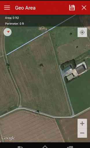
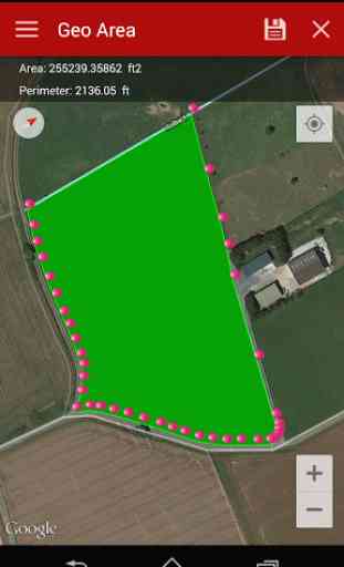
- Tap the map to mark area, OR
- Use the phone GPS receiver
- Ability to pause, start and stop GPS mode so that you can easily select the desired points
- Unlike our competitor Apps, Geo Area has NO RESTRICTIONS ON SHARING your data
- Not just an area calculator, its much more
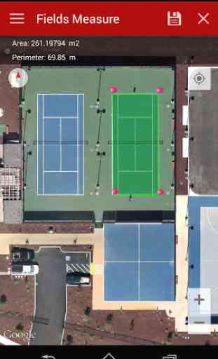
ACCURACY TEST EXAMPLE:
One of the screenshots shows Google Tennis Courts at (1600 Amphitheatre Pkwy,Mountain View, CA 94043)
- check this yourself to see how accurately Geo Area works:
Tennis court dimensions are: 36 ft(10.97m) x 78 ft(23.78m)Therefore, Area= 36 ft(10.97m) x 78 ft(23.78m)=2808 square feet(260.8666 square metres)Perimeter = Sum of all four sides=228 ft (69.5m)
You can change units from the application settings from feet to meters OR to acres OR to hectares OR to kanals OR to kilometers. Your choice!
GEO AREA LETS YOU DO THE FOLLOWING:
1. Measure the area and perimeter of just about anything on the ground as seen on Google Maps2. Use area and perimeter units of your choice including feet, meter, hectare, Kanal (area units for India), kilometer, yards, and acre.3. Either tap on the points of interest on the Google Maps to mark area, OR4. Use the phone's GPS to mark the field boundary5. Create Categories of your choice where you can group fields,please refer to the screenshots 6. Create unlimited categories7. Geo Area lets you share and see the marked fields on any GIS for instance the Google Earth
GEO AREA is for:
1. Land based surveys2. Farmers, for farm management3. Land record management4. Construction surveys5. Agronomists6. Town planners7. Construction surveyor 8. GIS data collection9. Health, Education and facilities mapping10. Farm fencing11. Sports track measurement12. Construction sites and building sites area13. Asset mapping14. Landscape artists15. Landscape design
Geo Area is used by farmers for several agricultural applications: crop yield estimation, crop area measurement, and agriculture yield. Geo Area has been used in conjunction with remote sensing (satellite imagery e.g. SPOT 6, SPOT 7) and GIS applications, to collect ground truth data, field records, crop yield, farmers data and agriculture output. Geo Area is ideal for land cover analysis, vegetation mapping and remote sensing where Regions of interests (ROIs) or the Points of Interest (POIs) or Area of Interest (AOI) collected through Geo Area. As seen in the example, Geo Area is ideal for area measurement (area calculator) and perimeter of sports grounds, cricket grounds, football pitches, tennis courts, badminton courts, parking lot area, residential space, running track and rental space. Several other applications exist e.g. transforming manual Patwari or Patvari and the old tape measure system for land record management.
Geo Area is customizeable for all crops including cotton, wheat, rice, sugarcane, sugar beet, maize, tobacco, Virginia, FCV tobacco, vegetables, banana plantations, dates and orchards mapping. Geo Area has also been used for forest mapping and GPS based measurement of deforestation area. Geo Area has also been used to estimate fertilizers, chemical spray, insecticides required for agricultural fields based on the calculated area.
Nothing is complete in itself
- we are learning from YOU to make Geo Area more useful. Thank you for your comments and feedback.
Category : Productivity
Reviews (28)
amazed to see how much popular this app has become amongst farmers and small builders - they all have one complaint though: ads rest this is by far a great app in the category
best app in this category. tried many others but its simple and accurate
it's a great effort, worth applause.
Very helpful apps.. Really like it ❤️❤️❤️
So far it has done everything I have needed
This app needs internet access.
Keeps crashing when I select gps mode!! Used the work fine on my previous phone
Liked it very much. Helped me alot and its too easy to be used.
Best for area measurement - simple and accurate. Kind of addictive to measure all historic places
Useful and easy to use says George
Absolutely best Samsung Galaxy S8 Edge
Very good app simple to use
Best app in the category
Simple and accurate
Best app
Love this
The point are nowhere near easy to readjust in real time. If we don't add the points in order it does not use the interior of the polygon near impossible to add 2 points near each other. No option to remove one point. No back feature. This are the must have. I would find useful taking photos and associate them to markers so in the terrain I could take photos to the border stone so i would know what to search in the terrain.
Description says that Points of Interest (POIs) can be collected, but I am unable to discover how. "Fields Measure" seems the only input method, and that requires a minimum of 3 points. No help information found, either built in or online. A shame as the basic area measurement seems good.
Works really easy. Very accurate. Would be great if I could import kmz files generated in Google Earth.
Perhaps you can consider adding tool for maping point layer and not just areas... But anyway great app... Nise job...
Easy and convenient!
Excellent efforts really enjoying this app and its functions. well designed. accurate results. GPS functions are awesome. please include shape file export option.
Great application for to me sure distance between two points and aria of the field it's result nearer to actual.
I love it. But it needs improvements. Some icons such as undo should be placed in the software. While you make a mistake during working , you should start fom the beginning.
Been looking for an area calculator and I finally found a free app that does the job. Very easy to use and UI is responsive and fast. Tried other free and non free apps but nothing is quite as fast as this one. Support for offline (vector) maps in the future perhaps?
Just what I wanted and does exactly as described.
Awaiting for this app finally found.
Most accurate and easily accessible application.. Loved to use it in field it just tells accurate acres measurement and other units also..