GeoFlyer Europe 3D - Offline Maps GPS Routing
How would you like a mapping app that shows points of interest in 3D with info or links to embedded Wikipedia pages?
GeoFlyer Europe 3D offers you all this and more!
The app is provided as a free Lite version, then a subscription or a permanent license purchase is available.
If you love hiking, biking, horseback riding, or any other outdoor activity, GeoFlyer 3D Maps is the app you need.
MAIN FEATURES
- Online and Offline modes (with preloading of selected areas)
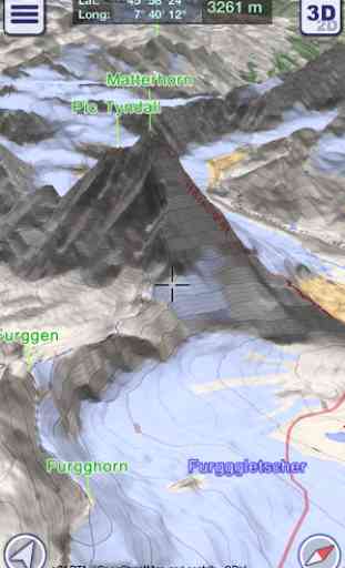
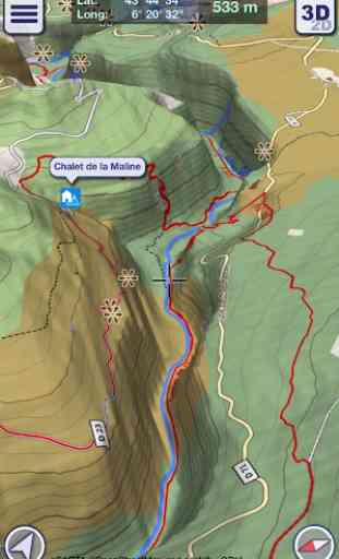
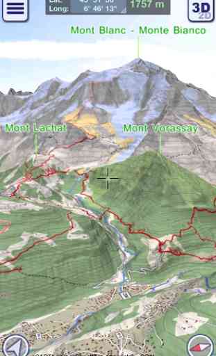
- Highly-detailed 3D terrain
- 3D labels/icons of Points of Interest (POIs)
- Integrated Wikipedia descriptions
- Place searching by name (Online and Offline)
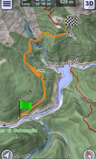
- GPS tracking
- Routing
- Personal Points of Interest (POIs)
- Import, export and share of tracks and routes with your friends and among your devices
- Altimetry graph and statistics
- Custom-made gCARTA topographic chart
- Augmented Reality Module
- Gyroscope features: GyroPilot
GeoFlyer Europe 3D reproduces the terrain in 3D with stunning details, using the best available digital elevation models from NASA and various European mapping agencies.
The terrain is overlaid with a custom-made topographic chart (gCARTA) that shows trails and accurate elevation contour lines, or aerial images if you prefer.
Find out more about a POI using the labels and icons. Wikipedia geo-tagged entries and other associated content are integrated right into the 3D map.
Plan your trip using multiple routing options, and save your routes for later use.
Record your GPS tracks and share them with your friends through Facebook or other social media.
Get the best from your outdoor experience with the “Augmented Reality” module, that enables to discover many details about the environment around you, thanks to the overlapping of points of interest and geographic names on the image taken by the camera.
And it’s fun! Try the GyroPilot mode: dive into the valleys with a low level flyby, handling your device like a virtual plane, and explore the maps like a top-gun pilot!
GeoFlyer Europe 3D… your outdoor companion!
WARNING
Continued use of GPS running in the background can dramatically decrease battery life.
Category : Maps & Navigation
Reviews (10)
I just bought app and I am really impressed with it. It has absolutely the best and the most precize altitude graph of all hiking apps I have ever seen. I hope the author will continue to develop and update this amazing app.
My horse a dog and I used it to walk 400 km in Spain last year and loved it! :) will use it this year to walk other 1,500 km :) I love it that it includes all public hiking roads like Camino de Santiago and gr7 it gived me an opportunity to don't have to plan every metre and feel safe I know where I am going as in Spain that can be a bit difficult with all the fencing, all thought it's better to look up where you gonna go online as it loads better offline later.
excellent app. pls add aircraft for routing.
As soon as I paid for the pro version, everything stopped working. How can I reach to the customer service?
very nice! ... and super usefull...
Really nice and useful application
Best hiking map I've used so far
Truly opens yours eyes to what is around you.
Not dramatic if you are not in the Alps etc. Can't see gyroscope in Acer iconia tablet so can't "fly". Not worth the "disc" space on my tablet
Best app ever in its category. Since I've been using it, the paper map is only for backup. The gCARTA map is the most accurate I've ever seen and integrates hike paths too. Import/export GPX, 3D function, offline mode - very important to save the battery - in the pay version. There is only one downside: Europe only. Very highly recommended!