GPS Air Navigator
Follow us on https://www.facebook.com/gpsairnavigator!
Main features:
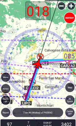
• real-time GPS moving map
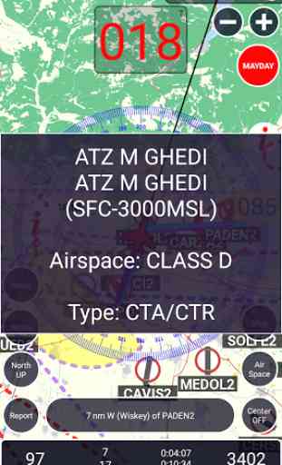
• graphical visualization of country air space
• navigation with True or Magnetic North
• airspace information for Portugal and Spain with daily updates (integrated with FuaFlex service
- www.cavok.pt)
• database with more than 56.000 system waypoints
• create and manage your own user waypoints
• create and manage your routes and legs
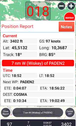
• MAYDAY button: send an automatic SMS with current location (only in devices that support this feature) and activation of a route to the nearest waypoint
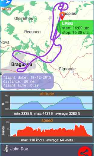
• show real-time flight tracks
• save flight tracks to a GPX file for offline processing (visualize in specific apps or inside the GPS Air Navigator)
• visualize your flight stats and share them on Facebook, e-mail, Instagram and so on
• only one licence needed for all your Android devices
After install, you can try the app with the following limitations:
• you can save only two user waypoints;
• the app closes after 10 minutes of usage.
If you like GPS Air Navigator, you can buy a licence (13,99 EUR) using the button Buy inside the app, to use it without limitations.
Enjoy GPS Air Navigator!
Category : Maps & Navigation
Reviews (27)
Please improve the creation of routes. Namely when adding a new waypoint and we give it a name, create the waypoint and add it to the route. It's annoying having the route window close each time. Another thing please add the ability to paste a coordinate from Google etc instead of manually doing each field. Please add the ability to import and export way points and routes. Thanks
I downloaded this app years ago and it worked exceedingly well until something suddenly went wrong. All the maps got wiped out and I am not able to download any maps even after uninstalling and reinstalling the app. Tried several times but it just doesn't work. An excellent app suddenly gone bad.
Warning❌🚫 This app tried to hack❌ my cellphone - i found unkown pictures, slow running etc just after installing. Request to appstore to delete this dangrous app imedeatly❌❌
Can't be used without SMS and phone access.
VEPT PAT PATINA, INDIA, ASIA PATNA (25:35:26N, 85:5:16E, Elev 169 Ft)SAD'sXiaomiredminote4ShaileshPrasad Sent from Yahoo Mail on Android updater flyer experienced
Don't download it asking payment
Need to update the maps wac from Brazil there are some places that chenged names
Easy to use
This app is good works well, I use it to navigate on air from places to places in Nigeria and is ok.
It looks ok but although I can download the New Zealand airspace there does not sppesr to be any maps. Where can I get a map to download or what type of map is needed? This is a new addition- Is there any easy way to enter a number of additional waypoints ? about 120
Please get good information about countries and the flag they have. CYPRUS is not that one. And you have to change it right now. That is our flag🇨🇾🇨🇾🇨🇾🇨🇾🇨🇾
They use the wrong flag for a European country, Cyprus. This is unacceptable. The flag they use is from an illegal republic of Cyprus.
The flag of Cyprus is wrong. You can find out which one is correct by searching on Google. It takes 2 seconds, see it's not that hard after all.
I only used the trial. The display was simple and for map navigation which is what I was looking for. The fundamental issue I found was when turning show UK air space the program went really slow to the point of unusable. My device ahould be capable of running the software. Also when clicking for airspace details it shows code instead of formatted table.
I have been using this app for the past 18 months and have used to to navigate long distance cross countries around South Africa as my primary DI. Easy to manage lots of great info.. Thanks to the developers. At the small fee its money very well spent!
I love the scenearie
Update now makes it work perfectly. Love it
Works in South Africa.! 👍
Loved that u updated the waypoints for Pakistan.... Will surely and shortly help with respect to exact lengths, freq, and nav Aids. 5stars
Really nice app air navigation. Developer has kind attention.
Thanks for making it look free and then after wasting my phone file space, finding out a few minutes later I had no navigation after airborne because you want a purchase you bait switch fornicator. Edit to add... To programmers business comment to free ovr paid....That's why many app makers release free versions with limited use of certain functions, to try it out, then you can use the full version u if u buy it. In the short time I used it I didn't find it functional to go simply from 3J6 airport to FD27
The device is fraud as it doesn't support any data in India. Google map will be a better app than this. Not worth even a penny. AVOID AT All COST. Sharing it with all my network of Pilots.
Unable to download map (south Africa) updates. "Download incomplete or cancelled, please try again"
Very unfriendly to use.
Can't use it because its upside down in landscape mode. Can't turn the tab around or the buttons will be unreachable in the panel.
Crashed before i could do anything
Lovely small app . Works all the time. The maps are a big download, I assume they are not vector. However, a good backup app. For a main use it is lacking a few features, like frequencies and airport information. The user interface is a learning curve and the VFR pilot needs to fumble with settings, not making much sense. When tipping an airport, I expect airport information, not setting a waypoint. It all relies on the openflightmaps, which is fine, but there is more data that could be displayed. After all, Communication is important. That information should be on a finger tip. good running backup map though.