GPS-Explorer mobile
To use telematic services for your vehicles / objects in order to optimize your business processes in the future? Then this is your application.
Vehicle, route and status information are transmitted live to the telematic services GPSoverIP ™ / DATAoverIP ™ / CANoverIP ™. By using this solution you will get an overview of the operations, processes, consumption and costs and can therefore optimize and reduce.
With the GPS Explorer mobile app for Andriod systems which also goes out on the road. So do not hesitate long. Download GPS Explorer mobile app and everywhere receive information on how economically your vehicles / objects are traveling, whether tours proceed as planned and at any time by giving short-term changes.
ATTENTION: a registered and activated GPSoverIP hardware is required with a valid account for this app. Please make sure before buying present your valid account data username and password.
DESCRIPTION
Which vehicle / object is closer to a destination?
Where are my vehicles / objects?
Since when the vehicle / object is traveling?
What is the current status of the job?
What is the current temperature in the hold?
Are my taxes free or busy?
and much more…
Fleet managers can manage the move of the vehicles / objects or the entire fleet. Even the shipping of motion tasks or messages directly from Andriod smartphone to drivers is possible with this app.
The GPS Explorer Mobile for Andriod smartphone is a full program for fleet management. It enables mobile access to the position located all in the fleet and a GPSeye (or a GPSoverIP enabled device) equipped vehicles / objects. The information is updated every second, allowing a real live tracking / locating the vehicles / objects.
FEATURES
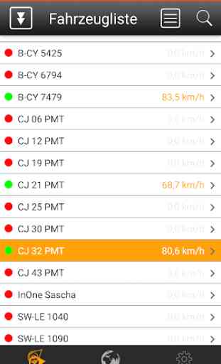
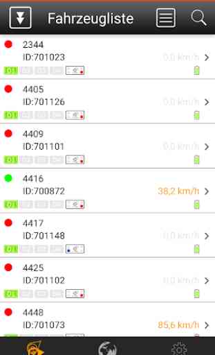
* Vehicle List
Provides information on the number of vehicles available for each account / objects including the respective motion status (moves / is).
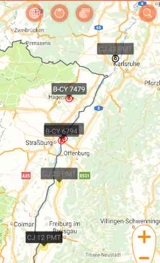
* Switchable map
Displays all the respective Account available vehicles / objects in movement on a world map indicating the current direction and the current speed.
Display of the own location by the positioning function of the Andriod device and the position of the desired vehicle / object.
* settings
Allows you to set the map (satellite, road map, hybrid) as well as the update interval and the activation of extended status information.
* Vehicle details
- Status Board
This can be by the driver via the so-called. Status Board such status define, which is displayed directly and documented.
- Taxi light status (Note: Here additional accessories required)
- Temperature display (NOTE: This additional accessories required)
- Digital Status
The Digital Status transmits automated status information. For example, on the door contact or the hydraulics. This status is displayed directly and documented.
(NOTE: This additional accessories required)
- Display the adjacent board voltage
- Display of the e-mail address and number of unread messages
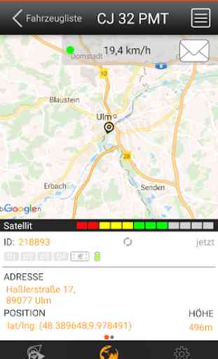
- Address resolution of position data
- Display of height
- Display of GPS signal quality
* More functions:
- Local Search in Map
- Marking locations on the map
- Web released
- Manual position query
- Timeline with replay function / lane
- Speed statistics
- Burglar
- Alarm function
- FMS data display
- OutputBox
- Navigation to the vehicle (via map app)
- Automatic Log
… and much more!
About GPSoverIP:
GPSoverIP was developed specifically for the transmission of GPS and user data in the mobile Internet and allows among others the live tracking of vehicles in the PUSH method. Vehicle tracking using GPSoverIP technology enables GPS location less than one second.
Vehicle, route and status information are transmitted live to the telematic services GPSoverIP ™ / DATAoverIP ™ / CANoverIP ™. By using this solution you will get an overview of the operations, processes, consumption and costs and can therefore optimize and reduce.
With the GPS Explorer mobile app for Andriod systems which also goes out on the road. So do not hesitate long. Download GPS Explorer mobile app and everywhere receive information on how economically your vehicles / objects are traveling, whether tours proceed as planned and at any time by giving short-term changes.
ATTENTION: a registered and activated GPSoverIP hardware is required with a valid account for this app. Please make sure before buying present your valid account data username and password.
DESCRIPTION
Which vehicle / object is closer to a destination?
Where are my vehicles / objects?
Since when the vehicle / object is traveling?
What is the current status of the job?
What is the current temperature in the hold?
Are my taxes free or busy?
and much more…
Fleet managers can manage the move of the vehicles / objects or the entire fleet. Even the shipping of motion tasks or messages directly from Andriod smartphone to drivers is possible with this app.
The GPS Explorer Mobile for Andriod smartphone is a full program for fleet management. It enables mobile access to the position located all in the fleet and a GPSeye (or a GPSoverIP enabled device) equipped vehicles / objects. The information is updated every second, allowing a real live tracking / locating the vehicles / objects.
FEATURES
* Vehicle List
Provides information on the number of vehicles available for each account / objects including the respective motion status (moves / is).
* Switchable map
Displays all the respective Account available vehicles / objects in movement on a world map indicating the current direction and the current speed.
Display of the own location by the positioning function of the Andriod device and the position of the desired vehicle / object.
* settings
Allows you to set the map (satellite, road map, hybrid) as well as the update interval and the activation of extended status information.
* Vehicle details
- Status Board
This can be by the driver via the so-called. Status Board such status define, which is displayed directly and documented.
- Taxi light status (Note: Here additional accessories required)
- Temperature display (NOTE: This additional accessories required)
- Digital Status
The Digital Status transmits automated status information. For example, on the door contact or the hydraulics. This status is displayed directly and documented.
(NOTE: This additional accessories required)
- Display the adjacent board voltage
- Display of the e-mail address and number of unread messages
- Address resolution of position data
- Display of height
- Display of GPS signal quality
* More functions:
- Local Search in Map
- Marking locations on the map
- Web released
- Manual position query
- Timeline with replay function / lane
- Speed statistics
- Burglar
- Alarm function
- FMS data display
- OutputBox
- Navigation to the vehicle (via map app)
- Automatic Log
… and much more!
About GPSoverIP:
GPSoverIP was developed specifically for the transmission of GPS and user data in the mobile Internet and allows among others the live tracking of vehicles in the PUSH method. Vehicle tracking using GPSoverIP technology enables GPS location less than one second.
Category : Business
Related searches