GPS Logger
The app is 100% Free and Open Source.
IT FEATURES:
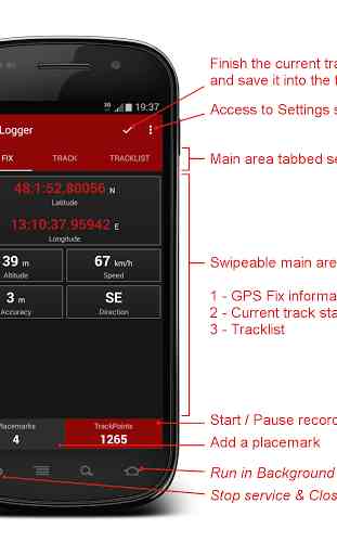
- A modern Material UI, with a low consumption dark theme and a comfortable tabbed interface
- Foreground and Background Recording
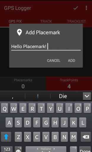
- Placemarks creation, with custom description, also meanwhile recording
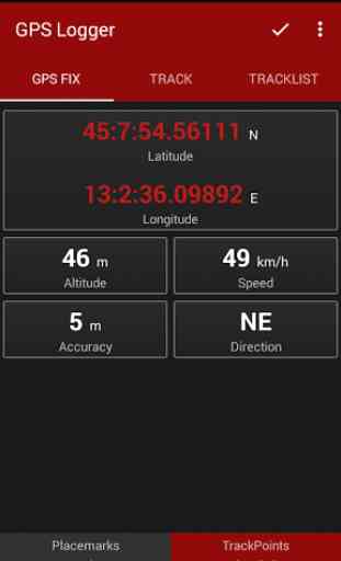
- Visualization of current GPS information: position, altitude, speed, direction
- Automatic Altitude Correction, based on NGA EGM96 Earth Geoid Model (Enable it on Settings!!!)
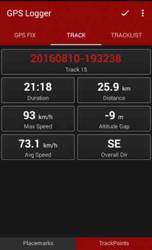
- Real time track statistics: duration, distance, maximum and average speed, altitude gap and overall direction
- In-app tracklist showing the list of recorded tracks, with a little thumbnail and the statistics of each one
- Visualization of your tracks using Google Earth (if installed) directly from the Tracklist
- Track exportation, in the /GPSLogger folder of your device, in KML and/or GPX
- Track sharing, in KML and/or GPX format, via E-mail, Dropbox, Google Drive, FTP, Telegram...
- Customizable settings for visualization of Altitude, Coordinates, Direction and Statistics
- Uses Metric or Imperial units
- Manual Altitude Correction (you can add an overall offset to your track)
Thanks to this app, for example, you can:☆ Keep track of your trips☆ Make accurate static and dynamic measurements☆ Add your placemarks during the trip, to remember the best places you've seen☆ GeoTag your photos☆ View your saved tracks directly from the in-app tracklist with Google Earth (if installed)☆ Share your KML and GPX tracks with your friends☆ collaborate to OpenStreetMap map editing
ADDITIONAL INFORMATION:
- Copyright (C) 2016 BasicAirData
- http://www.basicairdata.eu
- For additional information please see http://www.basicairdata.eu/projects/android/android-gps-logger/
- This program is free software: you can redistribute it and/or modify it under the terms of the GNU General Public License as published by the Free Software Foundation, either version 3 of the License, or (at your option) any later version. See the GNU General Public License for more details: http://www.gnu.org/licenses.
- You can view and download the source code of this app on GitHub: https://github.com/BasicAirData/GPSLogger
- When The EGM96 Automatic Correction is enabled for the first time into the Setting Screen, the geoid Height file is downloaded from the NGA/NASA website. (File size: 2 MB).
MINI FAQ:Q
- I've just installed the app, but it doesn't read the GPS signal.A
- Please try to reboot your device. Check also that the GPS signal is strong enough and, if not, go in an open area.
Q
- My track is shown broken in many points in Google Earth.A
- The application is set by default to show the track in 3D. Thus the track may be partially hidden under the terrain. Please go in the Exporting section of settings and switch the Altitude Mode to "Projected to ground"; your tracks should return fully visible.
Q
- How can I see my recorded tracks?A
- You can see your tracks clicking on it, using the "View in Google Earth" contextual menu. Google Earth must be installed on your device; if not, please install it. Google Earth is the best application to view a track, GPS Logger choose to use it instead of an internal viewer.
Q
- My Google Earth occasionally shows a black screen instead of my track.A
- It is a Google Earth problem. When the problem occurs, please click on the small bearing located in the upper-right corner of the Earth map.
Category : Travel & Local
Reviews (12)
Hi, looks like a great app and love that it is open source. I am unable to connect to any satellites. Using a Pixel 3a, I have tried restarting my phone as mentioned in several comments, followed the getting started guide, and opening the app in an open space. But the GPS fix tab always just says: "Looking for GPS 0/##". The ## is updating so the app does seem to be doing some searching, but the first number is always 0 satellites.
Very basic and that's what I like. Loaded it, tried it, and it worked👍 Wish I could use it with a Bluetooth or USB external GPS but oh well...
It simply works! Gave it to someone who've never seen it to log critical waypoints and working with it was intuitive.
Works great in the field, but I had trouble moving the coordinates to Google Earth Pro back at home. Each .kmz file was created with zero bytes of data, yet I could still see the data in GPS Logger. Ended up having to eyeball two screens at once to transfer coordinates manually.
Excellent app. Does what I need, and exports to GPX, KML and TXT (CSV) formats for easy processing on a computer.
Nice program ... I'm playing with Static DGPS(... Stop and Go Kinematic), with old cell phones ... My "MOTO's", log properly. My "TCL", not so ... Lats & Long & elev begin repeating after the 4th epoch, then 35 minutes of no change) ... Don't know if it's only the phone or the program & the phone "Wandering", DELTA LAT/LON/ELEV changing, should be almost exactly the same relation as long as the phones are within a few miles of one another and see the same sats ... I'm hoping for precision of maybe a few inches ... RINEX would be really nice ...
Almost what I need. I want something that can stay on in the background forever and simply log. I can then use the GPS data to locate my photos. What is keeping me from GPS logger is that it can not log slower than once every 3 seconds. To be on all the time, I just need to be able to enter a number here (which will be 20-30 times slower but save a lot of power).
This is a great app. Only slight issue is that from v2.2.10 you've added summary info into the. gpx export that now means it won't load into my mapping software without manually editing the file. It's there a benefit of the extra info in the file? Edit: I'm using Memory Map. I noticed that the summary was commented but it still won't load. Maybe I should refer to them?
Really like this app, can see where I've been by importing into Memory Map. However, since latest update to 2.2.10, the gpx file does not import directly. It seems to be the statistics that it doesn't like. Now have to edit file to delete these first. Update: If the statistics comments are moved to immediately follow the earlier comments, ie one block of comments instead of two; then Memory Map is fine and loads the gpx file.
Absolutely excellent for me so far. I've been able to log a 5 hour journey without so much as a hiccup so far. Plus many 2 hour ones. I just had to disable phones battery saving mode because obviously you don't want the phone to suspend the gps data while you are moving. Overall very happy indeed. I also love that this is open source software.
Best GPS logger. Reliable and precise. Great app design. You just have nothing further to ask of this.
As an application developer myself, I could tell right away that a lot of thought has been put into GPS Logger. It looks great and works great. And appearance is very important, as it can (and here does) enhance usability and intuitiveness. Very professional.