GPS Waypoints
The application includes the following features:
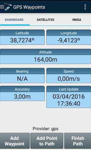
- Acquire positioning, navigation and precision information;
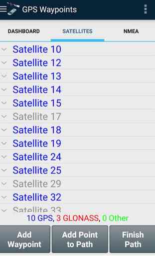
- Provide details of the visible satellites (GPS, GLONASS and other);
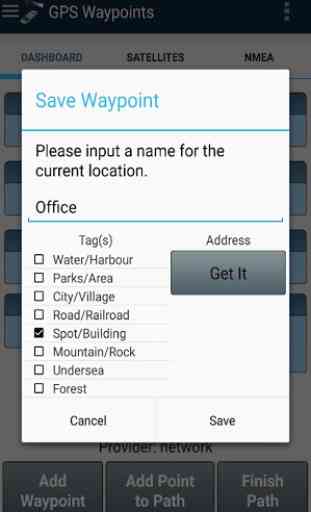
- Create Waypoints, geotag them and convert coordinates into a human-readable address (reverse geocoding);
- Create Paths from multiple acquired points and get distances between them;
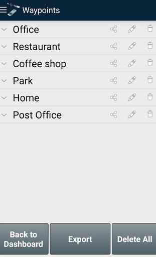
- Export points/paths to GPX or KML file format;
- Share data with other applications (e.g. Dropbox/Google Drive).
The current version was tested with the external receivers Qstarz BT-Q818XT and Navilock bt-821g.
For further information check some examples at the blog post http://www.bluecover.pt/?p=745.
Category : Tools
Reviews (22)
Not that good. Waypoints are recorded it is fine, but when I make a gpx file and import it into google maps, I get an error that 'file too large or unsupported format". now this gpx file is hardly of 1 or 2 kb so no possibility of huge file. So if I make a gpx file and import it in google maps, the format is unsupported. This is not acceptable for survey work. Hence this app cannot be trusted too much. Just an OK app, not much good.
Great app to check levels. This app has helped me check ground levels on a particular path and then chart my walk on to google earth.
It's a very nice GPS application. It's working fine on my phone. It has many features that works well. The data collected can be saved and transferred. I hope that the developer will add 2 more features like 1. the camera where the photos can be stamped with the coordinates, and 2. instead of showing only the altitude please add elevation option so that it will be helpful on ground surveys (this elevation is useful for the calibration of the survey points above the surface).
Just as promised, the UTM Co-ordinates are there and I am very pleased with this application. I recommend to everyone. Does everything well and it has impacted my career in a positive way. Waypoints can easily be exported to AutoCAD and accuracy on any snapdragon/exynos device is great. Thumbs Up.
Don't easily see a method to manually enter a waypoint as a destination. Seems the only way to set a waypoint is to be at the spot. Kinda worthless as a real nav tool. If the option is there it's not intuitive and required too much digging. Uninstalled.
I've been , it for a few days. Looks excellent, just what i need. one point, whenever the screen locks automatically or manually, it loses GPS and doesn't record a path.
Very smart and easy to use app for 2D or 3D field data collection. It looks fairly accurate as compared with some handheld GPS such as etrex, Garmin GPSmap76CSx. My compass is not working. How do I fix or activate it?
Life saving app. Very comprehensive set of GPS tools. Amazing for getting the best out of your phone GPS. I think the Bluetooth connection for external reveivers is also quite useful.
Well, that's really nice. This is a great app and when I got a new phone I exported all my waypoints from the old phone in KML format. Then uninstalled the app on my old phone thinking all was safe. But when I want to import the KML into the app on my new phone I find I cannot do this without buying the premium edition. So now I have lost all my data because there is no warning ehn you export that you cannot import without paying. I can import the file into a GIS programme but I cannot reenter these in the app because I cannot edit the date nor can I enter the co-ordinates. Very disappointed
This is a very user friendly app for GPS measurements. The best part is that you can take a picture of the waypoint and save it. You can export the waypoints and the path as klm files as well.
Very easy to use and delivers fast result.
Very useful to help me find Surveys markers
Not allowed to get the premium version on my phone or laptop.
Worthless waste of time! Had a number of waypoints that were saved...so I thought. When I tried to access them at home, they were gone. Nothing was saved! Beware!
Pretty accurate from my tests. Also easy to use in the field, easy to mark and save waypoints. It's my go-to outdoor nav app at the moment.
I am always looking for this kinc of apps. I am happy that finally got it and it works well with my phone and thank you.
Easy to use, flexible, friendly
Brilliant App... Takes a moment to steady the reading and is accurate to what it shows ... Also works without data or wifi ... Definitely on par with the Garmin Etrex ... Well Done ...
Edit: changed to four star. Most recent update (or a previous update). Seems to have fixed my dashboard issue, and the app is functioning as expected.
Great app, been using for some time now. Thinking of upgrading, just wondering what information is included within the csv? Are you able to build in additional data (UK X and Y coordinates for example)?
This app is great and navigating accurately and fast,but my request is please include option of Military Grid Reference system(MGRS coordinates) in coordinate format or position format, so has to hit a five star rating
I use this is my 400-level Aquatic Ecology class. Students use GPS Waypoints to map lakes, ponds, and wetlands. The students, as well as myself, love the ease of use and accuracy. Indeed, it's waypoint accuracy is often better than with expensive handheld GPS units when we've used ground-truthing. My students and me are anxiously awaiting an iPhone version so ALL my students can use GPS Waypoint. Keep up the good work guys!