GPS Waypoints Navigator
★ Typical Useage:
✔️ Trail Hiking and Track Recording.✔️ Offroad Navigation.✔️ Marine Navigation.✔️ Camping / Orienteering.✔️ City and wilderness exploration.✔️ Geocacheing
With dozens of options for navigating the back-country, waterways and roadways, the tool set found in this software package will quickly become your best friend. Venture beyond network reach using offline maps and tools that only require a good view of the sky. Share important location data with friends who will be able to navigate to your favorite waypoints and find your favorite trails. Get:
★ Unlimited access to our vector map library with over 400 maps. Download maps for offline use. Transfer maps to your SD card to free-up internal memory.
★ No recurring costs or subscription fees. Everything is included with your original purchase.
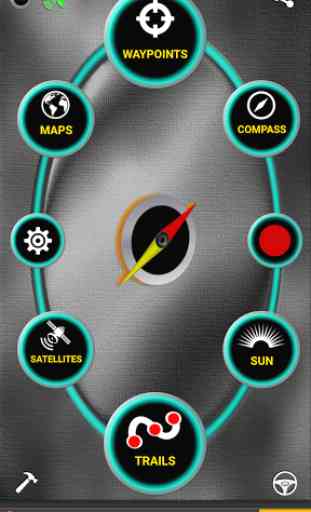
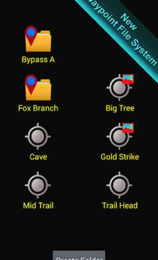
★ Waypoint and trail management systems.
★ Waypoint search.
★ Waypoint file system.
★ Waypoint photography.
★ Maps! Choose from multiple sources: Downloadable Vector Maps, Topo Maps, Google Maps, Satellite Maps, OpenStreetMaps
- MapNik, Mapquest, Cycling Maps OpenSeaMap, USGS Topo Maps, Canada Toporama, Trail Hiking and Biking, NOAA Nautical Charts.
★ KML, KMZ & GPX file importing and exporting for trails and waypoints. Share data and view in Google Earth.
★ Exported GPX files may be uploaded to freelogbook.biz for company route tracking.
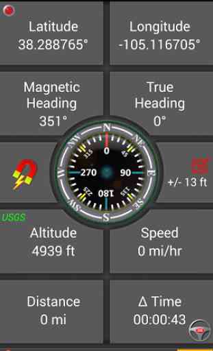
★ A panel for all your GPS parameters.
★ Navigational compasses.
★ Trail recorder.
★ Military coordinate finder
★ Several waypoint creation tools: Enter coordinates, set a waypoint by tapping on a map, save your current position or enter an address (voice entry supported).
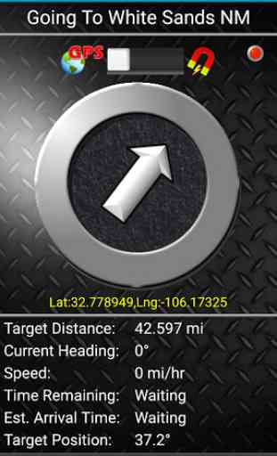
★ Two Waypoint Guidance Systems including a dynamic waypoint compass that always points to your target and a new navigation concept
- GPS Reflected Pseudo-Radar (available only from DS Software).
★ Map Search: Supports entry of addresses and coordinates in just about any format including UTM and MGRS.
★ Satellite reports and graphs
★ Email a map of your position. Navigation software not required on recipient's device.
★ Seamless integration with Google Earth.
★ Marine Navigation. Features NOAA Nautical Charts, OpenSeaMap and nautical unit reporting.
★ Supports several coordinate formats: Latitude/Longitude as degrees, deg:min or deg:min:sec, UTM, MGRS.
★ Proximity alerts.
★ Altitude profiling determined from your position matched to altitude values in land survey databases providing you with values that are more reliable than altitude values returned from your device's GPS chip.
★ Map with floating reticule that shows your position with bearing and distance to reticule.
★ Sunrise Sunset report
- Does not require a network connection. Useful for planning expedition turn around time or time to make camp.
★ Data is backed up allowing battery change without data loss.
Also get:
- Turn-by-turn driving directions and driving maps.
- You decide how compasses are controlled
- By GPS or magnetically. Use magnetic control for indoors, underground or in caves.
- Detailed Help file
- Excellent customer service
- Supports multiple languages: English, Spanish, German, Portuguese, Japanese, French, Italian, Russian, Chinese (traditional and simplified).
With GPS Waypoints Navigator, every navigation experience will be as easy as a walk in the park!
★ Recent Additions ★
- GPX, KML AND KMZ FILE HANDLING. EXPORT YOUR TRACKS AS A GPX FILE AND USE IT TO HELP BUILD OPENSTREETMAP. IMPORT GPX FILES FROM GARMIN. KML FILES ARE BEST FOR VIEWING IN GOOGLE EARTH.
- WAYPOINT PHOTOGRAPHY
- MAP SEARCH
- ALTITUDE SUPPORT: Choose Satellite, United States Geologic Survey location based altitude or SRTM data. USGS available only in contiguous U.S.A, Canada and Mexico.
Category : Travel & Local
Reviews (19)
I've found this app easy to use. It is a good value in my opinion. Update after a year of use. Still like the app but would like more trail color options. I'd like the ability to chose the color of my trails and have those colors permanently stay with the trail. Currently every time I change a trail selection the app shuffles the colors. It would also be nice if the header showing the trail name would change automatically as I go from one trail to the next so I new which trail I'm on.
Just started to use GPS Waypoints Navigator as a replacement for Viewranger. It looks quite good. But I wonder whether it is possible to show multiple imported gpx trails on the map at the same time in different colours?
It can't legally claim to be survey grade software, but I've used it numerous times in the field, gone back with surveyors and have been within a few feet. This will obviously not be the case when covered by a dense canopy, but even then you can get a fundamental bearing (pun intended) of accuracy. I upgraded for the extra features once I discovered the benefits of the app.
It has a lot of great futures but too many are not easy to use. The worst for me is spending countless hours finding way-points using Google earth then never being able to find them in the folders. They show up as useless scrolling icons so if you have hundreds like I do, it is pretty much impossible to find what you are looking for. Several times since owning this, I've ended up not being able to use it, having to go back to Google Earth / Maps to find our way around. It has lots of potential but the interface really needs help. Since it is software, with input, they will get it better and better and I'd love this if I can find a way of actually using it while we're out. I do see there have been updates but those do not show on the version I purchased and there doesn't seem to be any update/upgrade option. Add a way to see waypoints as we are riding up on them and that will make it much more useful. Bonus if it worked with my Samsung Galaxy watch so I didn't need my phone.
Works great, pretty straight forward nav app, has been 100% reliable. If I had to knock it on anything it would be that it isn't a pretty interface, and I can't seem to drop waypoints without going out of the map mode and into the waypoints menu. Also some of directory names are too long to be displayed in some menus. None are big enough gripes for me to knock off a star. This has become my go-to hiking and hunting app. Much more straight forward and less buggy than oruxmaps (my former fav.)
For various reasons, I prefer a dedicated Garmin GPS. Since I carry a smartphone on my trips because if has other capabilities, it makes sense to have an offline smartphone map to back up my primary GPS receiver. I choose this app because it provides a very simple method of determining an azimuth (bearing) to my destination (I do a lot of climbing that involves off-trail travel) - this is one of my bigger requirements for a GPS map and I am not disappointed. The maps are OK - not as good as the Garmin maps I create myself. I do create geospatial PDF maps from QGIS. It would be great if one could add custom maps to this app (so my printed map can match the smartphone map). I have tried making an MTBTile map, but it did not work. Otherwise, this app is what the author intended it to be. (Update) I figured out how to convert to MBTiles and it worked to my satisfaction.
Feature rich. One time fee without subscription. Maps with trails are the vector maps and open topo map. Many topo maps do not have marked trails. Does not show most commonly used trail. Look online or another app for that. Trying to drop pins to draw map ahead of time not very precise with finger. May be better with stylus. For me, I download maps and add waypoints by search which then shows up on previewing the map and makes it easier to find and zoom in to preview the trails beforehand.
I have only used this app to record trails while hiking. It has done a good job. My only issue was seeing tanget lines on a map instead of my actual route. But this is resolved when changing maps or finishing a trail. It's an issue that the Gaia app could not resolve, leaving me with trail maps with multiple errors and greatly exaggerated mileage.
This app, while it does have some good features, does not support importing gpx files. Gpx files can be converted to kml files and imported into this app but it displays them with large, intrusive icons for each waypoint making navigation difficult. Additionally it is slow and gets hung up frequently. It is also a power hog. I wouldn't want to be lost on some remote trail with it. I'll have to continue to wait for an Android app that can replace my clunky Garmin for Adventure riding.
I have found this app confusing and unintuitive for the user and I used to help guide people over the phone on how to use an app. I constantly battle the app and GPX downloads. I download from the same two sites. My phone downloads the GPX just fine from both sites. The file automatically opens on GPS Waypoints Navigator...sometimes. More and more lately it fails to open and I get a white screen error. I don't know if is the app or the phone that is the issue, but help would be appreciated.
At Ffirst looks it seems really good. But disappointed that trails in Polaris are not automatically imported. UPDATE: The popup did t show up before, now it did...thank you. I really like the ability to show and switch between the variety of maps including USGS contour, nautical, etc. Also, thank you for being so responsive.
Not nearly as functional as Google Earth (free). It will only display one trail at a time & does not display downloadable maps from TopoView (which Google Earth does flawlessly). I purchased it for its offline abilities, but the details on the maps that are available are very poor. I really regret paying for this app. Response: USGS topo is what I had downloaded. TopoView has 16 different maps available. Currently communicating with DS software, hopefully to get access to these maps.
Better than the high price annual fee apps, save your spot. Select go to, and walk right to your blind!!
Great app. It is easy to use and seems to be very accurate. The whole waypoint manager/trail manager feature is actually easier to use than my Garmin hand held gps. I already used it on a local trail and it worked flawlessly under heavy tree cover. I emailed their support about a question I had and they responded in less than an hour with the answer. I Recommend it highly.
Five Stars! I really appreciate this app when riding off-road. Ability to save various map formats for use without external data is invaluable when cellular coverage is limited. I love being able to import my own waypoints and trails in Google Earth Pro, and it is really starting to get interesting. Very anxious to get outdoors using this tool again so I can attach even more pics to my waypoints. Great customer support was fast and responsive when I needed help. I can leave my old handheld GPS at home from now on.
I upgraded to the gps waypoints app but I think the map manager in the navigator version is far easier to use and to see which maps I've downloaded. Also it'd be good to be able to add a waypoint directly on the map while traveling, and/or a MOB. Also, is there a way to show waypoint names on the map instead of just identical symbols? It would be a big help with navigating on the move.
I've tried every nav app out there, GPS Waypoints Navigator is the best by a million miles. I cannot find anything that comes close. Easy to learn, I make my routes on Google earth, save it in a desktop folder, then email it. Open the email, download the file and follow the red line. Been using it for about 3 years now. It's the best.
Pretty useful app. Does not require internet and has many unit options. It has the capability to import and export both KML and GPX for use woth most GPS systems and 3DEP programs. It could certainly be developed more to include informational features. I would be keen for grid views and the ability to import your own raster maps using either GEOTiff or KMZ.
Vector maps have not been updated in the last 2-3 years. If you don't download (and use) your raster maps - you may end up in the bushes...The app is only as good as the latest maps.