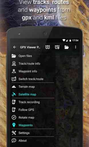
GPX Viewer PRO - Tracks, Routes & Waypoints
GPX, KML, KMZ AND LOC
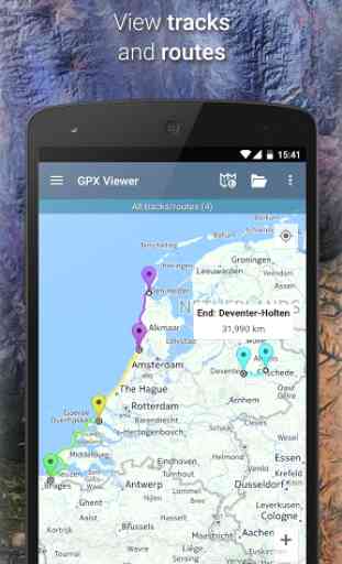
• view tracks, routes and waypoints from gpx, kml, kmz and loc files
• file browser which opens multiple files and has support for favorite files and history
• compress gpx files into gpz and kml files into kmz (zip archives)
DETAILED TRIP STATS
• analyze information and statistics for tracks and routes
• view graphs (charts) like elevation profile and speed profile for tracks and routes
• view graphs of other track data like cadence, heart rate, power and air temperature
• analyze information for waypoints and adjust their icons
• change track and route color
• colorize track and route line by elevation, speed, cadence, heart rate or air temperature
ONLINE MAPS
• online maps such as Google Maps, Mapbox, HERE, Thunderforest and some others based on OpenStreetMap data, preview: https://go.vecturagames.com/online
• OpenWeatherMap weather layers and overlays
• add your custom online TMS or WMS maps
SIMPLE NAVIGATION TOOL
• show current GPS position on a map
• follow GPS position continuously by adjusting map position
• rotate map according to device orientation sensor or according to movement direction data from GPS
• with follow GPS position and rotate map features, GPX Viewer PRO can be used as a simple navigation tool
• notification when GPS position is near waypoint with adjustable distance
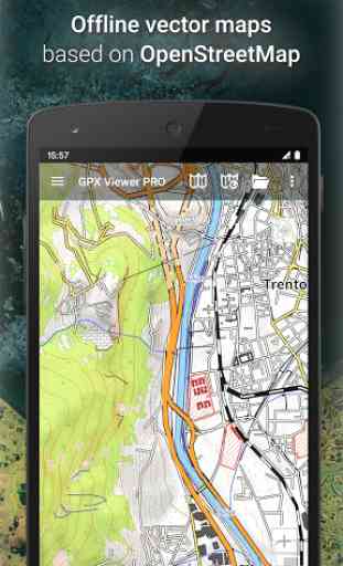
OFFLINE MAPS (PRO ONLY)
• detailed worldwide offline vector maps based on OpenStreetMap data
• wide variety of offline map styles from city to outdoor oriented styles, preview: https://go.vecturagames.com/offline
• monthly updates with improved data
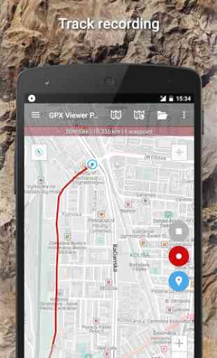
TRACK RECORDING (PRO ONLY)
• record and export your trips into gpx or kml files
• record elevation and speed statistics
• adjustable recording profiles for various outdoor activities
• distance or time voice notification
WEATHER FORECAST (PRO ONLY)
• weather forecast for next 7 days
• show hourly forecasts
---------
GPX Viewer PRO is highly customizable. You can set everything according to your needs!
If you want feature rich gpx viewer that is also offline maps app & tool with simple navigation, vector offline maps, GPS locator, GPS tracks viewer, trip stats viewer, GPS tracker and has other useful features, GPX Viewer PRO is the best app for that!
User Guide:
https://docs.vecturagames.com/gpxviewer
User Support:
https://support.vecturagames.com/gpxviewe
Category : Maps & Navigation
Reviews (16)
This is a fantastic app. I create GPX files in GMaps or Cotrex for hiking / walking. They load perfectly and are easy to follow with accurate mileage segments. Excellent customer service - I had a question about reversing routes and they got back to me in a few minutes - I was surprised at the response time. Customer service and help is vitally important when you need it and these guys are on it! Well done.
Brilliant app! I use GIS software to create offline maps and load into GPX Viewer Pro. It's like having Google Satellite view anywhere you go. Very handy for the Adventure Biking i do in remote areas of Oz. Perfect :)
Great! Downloaded TopoPro maps and get fast loading and lots of valuable features with off-line maps. Impressed for £4.49!
Unfortunately not the app I understood it to be. I was hoping the app and in no particular the pro version would allow users to create routes and save them as gpx files.
Not a very user friendly app. The more apps are changed or updated the less user friendly they get.
Very good, unfortunately I cannot see the waypoints labels...
It would be nice if the app truly downloaded all the information in the original geocaching file. The GPX file as downloaded onto my cellphone is extremely limited and has nothing of the original photos or other text data. Consequently, I still must manually download and save elsewhere for when I'm offline, out in the field. That said, I do like the maps that show all of a cache's waypoints, something I don't see on my GPXr. I also like the ability to quickly switch between map types.
This is the perfect app for those who like to plan their hikes using a desktop, download the kml/gpx files to their phone, and then use an app for navigation in a setting without a signal or data connectivity. It is well designed for this task, and aims to do nothing else, which I consider the right trade-off with respect to speed/responsiveness and battery consumption. The interface is simple an intuitive, and compared to some other apps it is very light on the battery (using up about 60% of my phone battery during a 8-hour hike, which is very reasonable; for multi-day hikes I carry a power bank and of course backup maps on paper if available). The PRO version is well worth it since it allows me to download offline maps, which I found to be high-quality (usually better than paper maps for most countries I visited). Maps are country-specific so it is easy to download the right ones in advance. I especially like the elevation display one can place below the map, it is very useful when planning rest stops with a group.
I'm using this app as a moving map for flying a complex pipeline system. It's outstanding. At 120 knots, position update is one second or less behind actual position. I had one issue concerning the earth kmls that were being loaded, customer support responded in less than an hour and a resolve fixed the issue in less than 24 hours! That is outstanding support!
Excellent app. Glad to upgrade to paid option for offline use of Topo maps.
Great off road app for hiking! Have recommended to several friends and family!
I usually use this app for navigating through my hikes. But on last Saturday, the offline map in the app stopped working when I switched the terrain view just before I am about to start the hike. Now I can not see the terrain. Only the route is shown which is pretty useless since the GPS does not work sometimes and one has to resort to look at the surrounding terrain for navigating during hiking. Got lost while hiking thanks to the app.
The functionality of the map is okay but the base maps available for offline are TERRIBLE. There are better apps that show better topo base maps. Also this app didn't allow satellite for offline maps. They have Google satellite view integration but only for online mode. What they need is the ability to download a map by explicitly drawing a box on the map. The UI I find tailored for online mode but confusing as to whether maps will work offline.
Works great! after getting lost in the middle of nowhere when Google maps decided to clear out the KML I was following. Downloaded the offline maps for my state and opened the KML. Simple and effective, just make sure you get it set up before you leave obviously. I'd like to see POI or waypoints be able to be added as a target, but it sounds like that is in the works.
Excellent for what I need. Glad I upgraded to the Pro version. I had been looking for an app that I could use as a 'cue sheet' for following my specific cycling directions recorded in waypoints and this does exactly that. I would like an option to turn off the 'bleep' for waypoint notification when using the Waypoint Voice notification. Or reduce the volume of the bleep because it is very loud compared to the voice notification, especially when using headphones.
Apart from being unable to select a specific route in the trackbook, which is probably more to do with me rather than GPX, this has never let me down. I absolutely love it and cycle around Germany all summer using it.