Great Britain Topo Maps
Easy to use Outdoor/Offline GPS navigation app with access to the best ORDNANCE SURVEY topographic maps and satellite images for UK (England, Wales & Scotland).
Turn your Andoid Phone/Tablet into an outdoor GPS for trips into the backcountry WITHOUT CELL COVERAGE. This app gives you similar mapping options as you might know from Garmin or Magellan GPS handhelds.
+++ Includes FREE OS 1:10.000 StreetView® maps ! +++
++ All topo maps are improved with HILLSHADING and contour lines generated from OS Terrain 50
- EXCLUSIVELY in this app ++
Included FREE map layers:
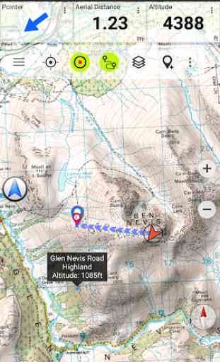
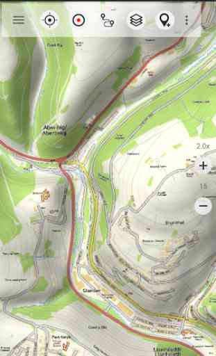
• OS Topo Maps: This layer combines OS VectorMap District™ and 1:10.000 OS StreetView® maps, enriched with hillshading, contour lines and additional placenames !
• OpenStreetMaps : These crowdsourced maps are a very useful addition to the OS maps
• OpenCycleMaps: These maps are ideal to plan bicycle trips
• Google Road Map (online access only)
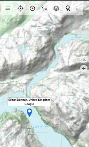
• Google Satellite Images (online access only)
• Google Terrain Map (online access only)
• Bing Road Map (online access only)
• Bing Satellite Images (online access only)
• Earth At Night
• Hillshading overlay layer for OSM, Google or Bing maps
Available Premium Maps:
1:25.000 OS EXPLORER MAPS can be downloaded via In-App Purchase. Explorer maps costs vary from 5.5 £ to 28.5 £ per county (One time fee
- Explorer maps can be installed on all devices that are logged to purchasers Google account). For example the whole county of Aberdeenshire as 1:25.000 Explorer maps costs only 15.45 £. And: With the purchase of a 1:25.000 Explorer map cache pack ALL PRO Features WILL BE UNLOCKED !All OS Explorer maps are in excellent quality with HILLSHADING (only in our app) ! Why should I obtain OS Explorer maps ? Answer: These are the best maps for hiking and other outdoor activities. Explorer maps contain many features (like small trails or points of interest) that are missing in other map sets.
Main features for outdoor-navigation:
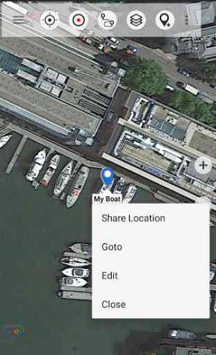
• Create and edit Waypoints
• GoTo-Waypoint-Navigation
• Track Recording (with speed, elevation and accuracy profile)
• Tripmaster with fields for odometer, average speed, bearing, elevation, etc.
• GPX/KML/KMZ Export
• Search (placenames, POIs, streets)
• Customizable datafields in Map View and Tripmaster (e.g. Speed, Distance, Compass, ...)
• Share Waypoints, Tracks or Routes (via eMail, Whatsapp, Dropbox, Facebook, ..)
• Display coordinates in Lat/Lon, UTM or MGRS/USNG (Military Grid/ US National Grid)
• Record & share tracks with statistics & elevation profile
• Rotate map (Track Up & North Up)
• Get Elevation by long click on map
• Track Replay
• and many more ...
Available Pro features: (Pro features available via In App Purchase or come free when OS Explorer maps are purchased)
• Offline Use
- no cell coverage needed
• Easy+Fast Bulk-download of map tiles for OFFLINE USAGE (not for Google and Bing maps)
• Create and edit Routes
• Route-Navigation (Point-to-Point Navigation)
• GPX/KML/KMZ Import
• unlimited Waypoints & Tracks
• Add Tile-Server
• No Ads
Offline Use:All viewed map tiles are kept in cache. To cache large areas you need to purchase Pro features.
Use this navigation app for outdoor activities like hiking, biking, camping, climbing, riding, skiing, canoeing, hunting, offroad 4WD tours or search&rescue (SAR).
Add custom waypoints in longitude/latitude, UTM or MGRS/USNG format with WGS84 datum.
Import/Export/Share GPS-Waypoints/Tracks/Routes in GPX or Google Earth KML/KMZ format.
Preload FREE map data for areas without cell service (Pro feature !).
This app does NOT provide 1:50.000 OS Landranger maps: There is no need for the Landrangers as the included free OS Topo Map layer is better !
Comments and feature requests to [email protected]
Have a look at our other outdoor navigation apps: https://play.google.com/store/search?q=atlogis
+++ We DO NOT track any user activities or collect any user data ! +++
Category : Maps & Navigation
Reviews (21)
App appears to be okay, but didn't use it out in the field before uninstalling. Paid £11+ for OS 1:25k map of Gloucestershire only to find that the downloaded map is not the latest version from OS - possibly between 5 and 20 years behind current version. Also a worry is the state of the website for this app - requires Flash Player and links do not work (try clicking on "Mapshop"!). And the app hasn't had any updates in almost 6 months. The age of the OS map, the website and lack of update to the app doesn't fill me with any confidence - hence am not going to spend any more time (or money) on this app.
Have used this app for 2 years. Have spent significant amounts of money on map tiles. Recently stopped working. Contacted support who suggested various fixes none of which worked. I then tried it on a new phone with the same problem. 5 days ago was told if suggested fixes did not work then I would be given full refund. Contacted them to request a refund and I have not heard anything for 72 hours. I can no longer recommend this app as it is no longer usable for me.
Good when it's working but it's very buggy. I purchased the a os explorer add on using my phone but it doesn't show up on my other android tablets tried it on two using the same account. Contacted the developer just got a reply saying are you using the same account. Contacted them twice more but was ignored. Poor customer service.
It's ok when working but I have to reboot my phone to get it to work again after quitting. Too annoying, I wasted £30 on an unstable app and acouple of maps. Very disappointed. I use locus maps now, that works well.
Yes I use the app a lot hill walking. I plan a route on a PC. Looking for all possible hazards. Then create a route in the app. On the day I record my trail. It's a great way to navigate so long as you prepare. The app sometimes forgets I have paid but eventually can be made to remember.
Excellent alternative to viewranger for mapping and route plotting now that it's being removed, ~£3 a year or a one of £10 with a free trial is definitely worth it and hardly an expense Am enjoying it with good features Mostly I love the OSM landscape map
Don't waste your money purchasing maps. Constantly disappearing from my phone and a struggle to restore. Very unreliable. Something has happened recently - was a 5 star app now having problems with purchased maps from OS map shop. Keeps loosing cash pack and now whent I try to restore just reports file not found 😕 Updated Did contact support but have not so far been given a solution. It is getting worse.
June 2020, seven? (lost count) updates later and it still crashes. Nice looking app but it won't open purchased map. Absolutely no response from support to multiple requests for help. Wouldn't have purchased had I known there's no support. Very poor.
It's brilliant. I've used it to find all the public footpaths in my area and I've enjoyed exploring them. And because of the lockdowns there's not much else to do so it's been great. There is an initial cost but it's worth it. Nothing good is free in the app world.
Good, adaptable mapping app. Offline is essential but sometimes problematic to download. Please add what3words capabilities. Edit What3words is now incorporated. An excellent package with good functionality.
Good alternative to an OS map. Easy to read in standard Topo format but in street view paths can be a little difficult to read due to the line thickness and colour contrast being similar. No adds though so in balance 5 star.
I WAS LOOKING FOR A MAP THAT SHOWED O.S. FOOTPATHS.GREEN LANES.BRIDAL WAYS.RAILWAY LINES ETC FOR MOTORCYCLE TRAIL RIDING AND THIS APP DOES WHAT I WANT. IT'S CHEAPER THAN THE "OFFICIAL" O.S. MAPS AND JUST AS GOOD. THE DOWNLOAD AND PRINTABLE OVERLAYS MAKE THIS APP VERY CHEAP COMPARED TO O.S. MAPS. THE ONLY THING I'VE NOTICED THAT IS NEGATIVE IS THE DELAY IN DOWNLOADING OVERLAYS. BUT AS ITS NOT SOMETHING THAT IS NEEDED INSTANTLY IT'S NOT A PROBLEM WAITING A MINUTE OR TWO. PRICED @ SUB-£4 ;-)
Is great when it works. Half the time I set the tracker and when I lock the screen to stops. Or I check where I against the route and loose the progress :/
Not happy with this anymore. I had to reinstall when a purchased OS map showed as defective but now I can no longer access the map I have purchased even though it shows as purchased.
maps are ok, but no "key" for cycle routes, so cant find what each colour route means. To not explain map symbols is mapping disaster. The "contact us for help" is useless as nowhere can I find their contact details!!
Superb! But I would like to see some maps for Northern Ireland included. There's nothing that covers here and I bought this hoping to get some closer images
Hi, I really like this ap but I have downloaded 2x OS maps and they won't show up in the map index. I'm not sure how to contact the developer.
Maps lack in detail and you cannot zoom in all the way with your fingers, instead you have to use the + button.
Just been billed for an update. I had already purchased the pro version. Fortunately, the billing failed due to my old card being listed in their data. Why am I being billed?
Miniscule text. Shortly gets larger when zooming, then back to microscopic size. Can't be changed.
Thanks to a scale that is detailed enough to decipher important landmarks, all these topographic maps are pretty good. It would be nice, however, to have them as modules in and under one "Topographic Maps" umbrella app, instead of flooding the phone with two dozen icons for all the maps as separate entries.