Guthook Guides: Hike & Bike Offline
UNITED STATES NATIONAL TRAILS:
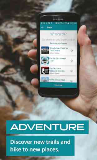
Appalachian Trail
Pacific Crest Trail
Continental Divide Trail
Arizona Trail
Florida Trail
Ice Age Trail
Pacific Northwest Trail
UNITED STATES REGIONAL TRAILS:
Buckeye Trail (Ohio)
Colorado Trail (Colorado)
John Muir Trail (California)
Mid State Trail (Pennsylvania)
Mount Whitney Trail (California)
Ouachita Trail (Arkansas)
Ozark Highlands Trail (Arkansas)
Pinhoti Trail (Southeast)
Tahoe Rim Trail (California)
Buffalo River Trail (Arkansas)
Eagle Rock Loop (Arkansas)
Benton MacKaye Trail (Southeast)
White Mountains (New England)
Long Trail (Vermont)
Wonderland Trail (Washington)
CANADA
Great Divide Trail
NEW ZEALAND:
Te Araroa
Routeburn Track
Kepler Track
Milford Track
AUSTRALIA:
Bibbulmun Track
Cape to Cape
Larapinta Trail
Overland Track
Three Caples Track
Wilson's Promontory Grand Circuit
UK & EUROPE:
Camino Frances / Camino de Santiago (France & Spain)
Croatian Long Distance Trail (Croatia)
Coast to Coast, Wainwright's (England / UK)
Cotswold Way (England / UK)
Hadrian's Wall Path (England / UK)
South Downs Way (England / UK)
The Ridgeway (England / UK)
West Highland Way (Scotland / UK)
Key features:
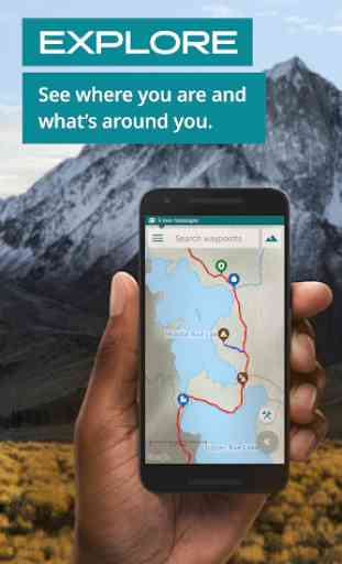
—Detailed maps including GPS location, detailed routes, and waypoints
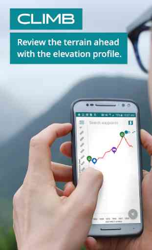
—Elevation profile view with GPS and key features
—Custom route creator to plan your trip
—Multiple background map choices
Waypoint data:
—Waypoints are plotted on the main trail, approach trails, and side trails
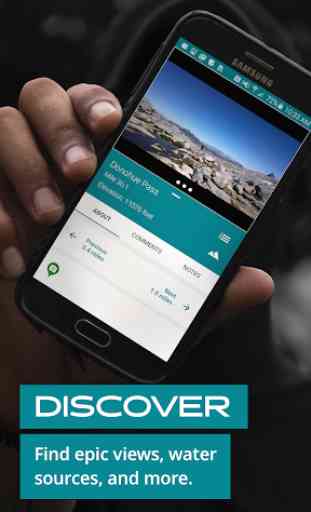
—Water sources, shelters, camp sites, road crossings, trailheads, viewpoints, peaks, and much more
—Town details including accommodation, restaurants, resupply, laundry, other services, historical sites
Category : Travel & Local
Reviews (27)
Was having trouble after all the maps got moved to this single app, but customer service was extremely quick and helpful with getting my purchases restored. I've used these guides to hike a ton of miles, and love that I can tune into peoples' real time experiences with things like water sources and town accommodations in the comments.
Definitely an app worth recommending for many trails. One star down only due to alternate trails or own routes showing partially incorrect trail distances or altitude gains. Regardless, must have for many trails if you want to make your life easier.
I have used Guthooks on appalachian trail for years. The comment section is absolutely wonderful for determining appropriate campsites and viable water stops. This is a must have app for any thru hiker on the Appalachian trail.Update, I don't like that they keep changing the app name.
Incredibly incomplete maps. Limited options for maps. Crucial resupply close to trail not listed. Content from other hikers more valuable than what's provided. Review is based on thru hike of the AT but have seen nothing different in the other maps I've purchased PCT, AZT and CT. Maps not as detailed as latest available topo and zooming limited.
Great app for hiking the Ice Age Trail. I hike with paper maps and FarOut and use the app pretty much every time I hike. They work directly with the IATA to ensure that they have the most up to date info and have been very responsive when I have reached out. I'm hiking the full trail and the investment has already paid itself back in helping me find upcoming water, camping on-trail or getting me un-lost that one time I missed a blaze deep in the national forest. Topo feature and waypoints
Not only are the maps and guides an amazing asset to the trail exploring communities but their customer service is what has just won me over! I had an issue where my map packs and bundles that I had already purchased were not showing up on my account after switching to a new phone. I sent an email to their customer support and within a day an actual human person emailed me back with 3 or 4 solutions to the problem. Next day all my maps were available again on my new phone.
Used this app in 2018 for the AT and 2019 for the PCT, came back to the AT to do some section hiking and this new app has been nothing but trouble. Forst not showing any of my previous purchases, to way points not showing up after following all their steps to correct these issues I'm pretty annoyed for what Im getting in correlation to what I invested. Headaches.
In the old Guthook app I could list all the water sources and it would show me how far are they from my position. This would make it super easy to figure out how much water I need to carry. Now there is only a list. How do I figure out how far is the next highway crossing that allows me to get in town and resupply? Do I have to subtract the mileage in my head? Instead we get a "Search waypoints" field which does not add any benefit. I loved the old Guthook app but I am disappointed with this new version. I do like the website which allows you to plan your adventure on your computer with big screen. However I hope they bring the mileage between water sources and trail towns back.
Very helpful information about water sources, shuttles, hostels, and tentsites. Works well on airplane mode and contains offline maps. Would strongly recommend for anyone hiking the AT.
Amazing Got new phone lost my maps when the app was downloaded with proper proof that I had previously purchase the maps they downloaded the maps to my new phone. I purchased the maps a year ago and spent 6 months trying to find the receipt. Just saying that not alot of people run a business like this thank you farout
Maps that I purchased on Guthooks did not migrate over to FarOut. FarOut says that I own Springer to Standing Bear Farm but it won't let me open the map. As a side note, since the change to FarOut, opening new maps has become very unintuitive. You have to open the shop page just to load a map you have already purchased and downloaded. Please let us switch directly between maps we already own.
Have not been able to login since Guthook became Farout. I seem to have lost access to my account and purchased maps. Have tried repeatedly to recover my account but have never received an email. Obviously I can't give a good review when I can't even use the app.
Update. 04/04/2022. On its thrid iteration and I still love this guide app. Can't recommend it enough. Update. 10/18/19. Had a pretty solid gripe about the new version of the app. Reached out and was not prepared for the level of responsiveness i received. The AtlasGuides crew is amazing. App works great, developers and customer service are ON POINT. Customer and proponent for life. Thank you.
Great Ap ! I used briefly on the AT ( Appalachian Trail ) in 2020 and it kept on the trail even when the trail wasn't blazed. I like the "social network" part where you can post and read comments about water sources, businesses in trail towns. I recently upgraded my phone and for some reason the switch software I used didn't transfer my downloaded maps. Tylerwas kind enough to reset my account so I could re download everything, and told me how I could save all the maps and photos to the SD card in my phone. Thanks Tyler !
I've bought and used FarOut for my Long Trail thru (complete) and AT LASH (upcoming). It should be a no-brainer for anyone doing the same. You get accurate GPS of the trail, all sorts of planning stuff (water, campsites, town) and the big advantage is the depth of information, both from the app developers and fellow hikers. More than once, I've run into some poor unfortunate who didn't know about the app, all it takes is to show them the info they need on the app and they all download it.
I've been using this app since 2014. Through many updates and changes, some I liked better than others, the app has been consistent in providing an easier and great trail experience. I recently had an issue with uploading previously purchased sections/trails on the new edition, FarOut, but with an email to customer service I was walked through a clear and honest experience to restore them, Thank you Tyler. I look forward to continuing to use, support and recommend FarOut.
Trail guide was accurate & reliable. Made some notes based on the trail guide i downloaded and was able to navigate just based on that. Topography is also much appreciated
Great customer service. Maps are accurate and community comments on waypoints are super convenient. Would love to have the ability to toggle map layers.
It's a great hiking app. Good enough to justify the weight of a mobile phone and backup battery if you aren't already carrying those.
Used the app for both my AT and PCT thru hikes along with a section hike on the CDT. The guides are easy to use and are a must have for a long hike. Everything you need to know about the trail is at your fingertips. Also had fantastic customer service when I had a small issue with the app. Highly recommended this app to any hiker.
Tiny features could be improved but as it stands it's at least as useful as any paper versions of the maps I've seen.
The customer service was awesome. I had an issue in getting my guides to the new Farout app from guthook, Tyler Lau had responded quickly and provided detail instructions on how to resolve the problem. He also emailed follow ups on my progress. 5 stars for Farout customer service.
Great app and guides, if you hike these are a valuable tool to have. And the support for any issues is very helpful and quick to reply and resolve any issues you may have. Would highly recommend!
Fantastic app for navigating the PCT, I was using Halfmiles but paying for the maps here is worth it. Maps, waypoints, comments, tent sites, water, resupply.
Amazing App. It was all I needed to walk the PCT Trail and Arizona trail. The detail and resources ( eg. Water sources) are invaluable. Very easy to use, uses very little phone battery, and best of all it can be used offline. I look forward to using the App on upcoming trips outside North America.
App is fantastic for just about everything on trail. Only criticism is that there seem to be a many campsites on Pinhoti that aren't marked, often near water. And, conversley, many water sources are not marked and near campsites. Using comments though, it's pretty easy to pick up on these missing details.
Very helpful and a must have on the trail. Careful, water sources are not always up to date. Some places had them with no spot on the map, others were bone dry/ seasonally but users have to update those so no negative points there. Still figuring how to use the app, learning something new each day from fellow hikers that have it. Life Saver!