Guthook's AT Guide
NO PHONE OR INTERNET SERVICE IS REQUIRED to use Guthook's Guides after the initial setup. Guthook's Guides use a combination of your smartphone's GPS, downloaded topo maps, and the Google Maps interface to accurately locate your position on the trail. Your phone's GPS pinpoints your location on the downloaded topo maps.
The free demo covers the 8.8-mile Springer Mountain Approach Trail from Amicalola Falls State Park to Springer Mountain southern terminus. The demo is fully function with all features of the paid version. In-app purchases include 9 sections of the AT and the Long Trail in Vermont.
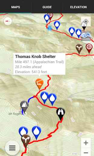
A bright red line indicates the location of the main trail on the map. Side spurs to water sources or other points of interest are indicated in other colors. Waypoints of interest to the hiker are plotted on the map. Tap on the trail to get mileage and elevation data.
The elevation profile shows trail distance vs elevation and plots your current location on the trail. Each waypoint is plotted on the profile. Each waypoints is clickable, opening to the waypoint's detail page.
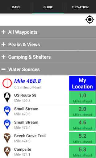
The guidebook lists every waypoint in order by distance along the trail and how far away you are from each waypoint.
Send your current location to friends and family via text message or e-mail.
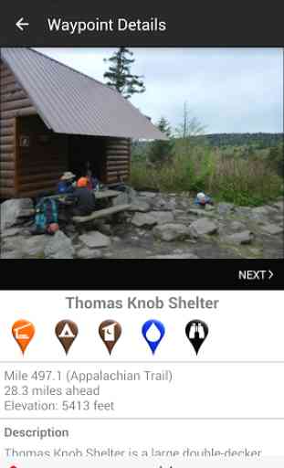
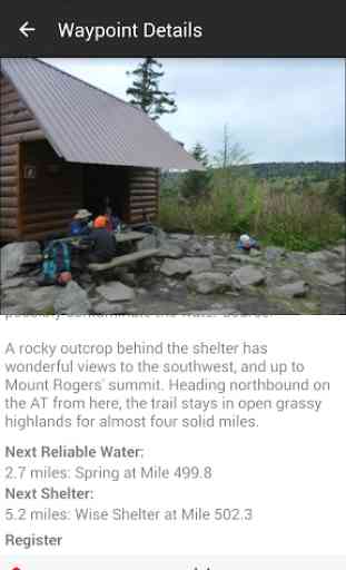
Each waypoint includes a detail page, providing further details about that particular waypoint. Details include the waypoint's mileage point and elevation, photographs of the waypoint, distance to the next water source and shelter, a Trail Register where you may post comments and read other users' comments, and other details that will help you during your hike, and help you plan your hike.
The types of waypoints include:
-->Water sources (including the reliability of each water source)-->Shelters/cabins/huts-->Tenting sites/camping sites-->Trail junctions-->Parking areas and trailheads along the trail-->Picnic areas, campgrounds, ranger stations-->Roads, railroad tracks, power lines-->Natural landmarks (e.g. mountain peaks, lakes, bogs)-->Privies/restrooms-->Scenic Views-->Towns on the trail
About the Appalachian Trail: The Appalachian Trail, or AT, is one of the United States' most treasured national trails. The 2,168-mile trail stretches from Springer Mountain in Georgia to Mount Katahdin in Maine. Along the way it passes through 14 states, including Georgia, North Carolina, Tennessee, Virginia, West Virginia, Maryland, Pennsylvania, New Jersey, New York, Connecticut, Massachusetts, Vermont, New Hampshire, and Maine. Much of the Long Trail overlaps the AT through the State of Vermont. Many hikers complete the entire trail in one season ("thru-hikers"), and countless others enjoy hiking anywhere from a few miles to hundreds of miles each year.
Category : Travel & Local
Reviews (25)
App was perfect when I first started using in 2018. Offline maps are extremely useful in maintaining battery life when on the Trail for weeks/months. Started using during the 2019 season and it seems quality has dropped. Despite downloading the maps I needed for offline use, the app will lock up and either require a long amount of time to start up or multiple restarts to become useable. However, once started, it is still as useful as before.
This app is just the absolute best. But I have a complaint. Idk if it happened in the last update or if it's been this way and I just never noticed until now, but the automatic screen rotation (even when screen rotation is off on my phone settings) is a total bummer. I can't lay down in my tent and check my route for the next day because the screen flips sideways and I can't maneuver the app properly. I'll change my rating if there's an option to turn off rotating to horizontal screen.
The most expensive app I've ever bought, but it's one of the most comprehensive navigation tools I've ever used. A fancy GPS watch won't even be able to tell you where every spring is or whether it's currently flowing. If you do much backpacking on the AT, Guthook is a good investment. I will say though, try not to check it too often, while you're actually trying to crush miles.
I just paid $8 to buy a small section of map on this app and so far very unimpressed. The custom route feature does not work. I pick a starting point and an end point and save...nothing. Also, I cannot find any way to get it to tell me the distance between 2 way points of my choosing. Without this feature I find the app's uses very limited. I want to be able to find out how far of a hike it is between 2 points of my choosing, not just the next waypoint on the trail. update: The custom route feature is now working. We'll see how long it does.
I purchased all the AT segments but then my phone broke. When I got my new phone they all disappeared and I have to buy them all over again. This would be frustrating but it doesn't matter now because the app is just frozen. I guess I don't need to worry about it anymore. Going back to the data book. Technology only works if it works. Your better off with an old school map and guidebook.
I love the old app and all the features and useful comments left by other hikers. I have recommended it to countless other hikers. I used it last summer and just went to use it again and my saved routes are gone and I cannot find a place to recreate routes. Also, all of the past comments/ recommendations/ note from other hikers are completely gone (water source dry, mice at shelter, etc.) Am I missing something? The most useful part of the app was being able to look back at the old comments
I'm only using the Alabama Pinhoti map so far. It's a nice resource to have but conflicts in places with the official trail guide. Additionally, not all the waypoints noted are sound (i.e. tentsites) but there are others that exist not listed. Probably the feature I like least is that the scale is off for distance and elevation, making a 600 foot climb over 2 miles look like you're about to scale Everest! However, it's useful to be able to check if you're in the right place and have a topo.
This is the definitive AT hikers app. Totally worth the map packs. If you aren't doing a through hike just go for the sections you frequently use. Definitely worth it. If you are doing a day or two hike this app is a life saver. It gives both topo map and an elevation scale which is super nice. It has water sources with pictures and recent updates from users.
This is a wonderful app for day, section, or through hikers. The community content was invaluable during my last trip because of drought in the area. Thanks to other users' posts, I was able to know where I could expect (or not expect) water. It runs in airplane mode no problems using GPS and I didn't notice any significant battery drain.
Amazing app! It's very informative and a gives a nice sense of security on the AT. I use it to set my routes, look at mileage on the trail, and see the elevation profile. It also does a good job of communicating where shelters, campsites, and water sources are.
I had this on my old phone for my 2016 AT hike. I bought the full set but have some northern parts to finish, so I wanted to get the maps on my new phone. I tried to sign in, and forgot my password (or maybe it wasn't saved from 2016). It said I could reset it; you were going to send an email, and even though I tried twice, I never received it! Edit: Tyler helped me through it and I have my maps back!
This app is great, when it works. Which is 90+% of the time, I'm happy to say. However, there have been a few times where certain information is all of a sudden missing. Not sure what's going on or why but when the information is there, it is spot on and extremely helpful! When it's not there, I get frustrated as to why it disappeared and how I can get it back. It can be terribly annoying when this happens on trail.
I have used this to guide my family and I along over 130 miles of section hikes through PA. The info was accurate to the mile and never let us down. Easy to use, and I love that there are reviews, notes, and commentary. Also, the app is gentle on battery life while you're out there, which is a relief!
The app has changed.. I very much miss the feature where you tap a trail feature and there is a reading of how far you are from it... The longest mile of the day is always the last one. when tired and moving I took for granted that guthhok would do the math for me.. until now that it is gone!! Please put this back in.
Best app ever! Definitely worth every penny. Works without service even in airplane mode. Has saved me from getting lost so many times. Great to use to plan mileage and where to tent or shelter. Even helpful with off trail things such as hostels, shuttles, food, etc. So glad this was recommended to me
I've used this app for over 150 miles of hikes on the AT in Georgia and I love it. Too many awesome features to list, but they all work great and are a huge help on the trail. Well worth purchasing the sections in your area, or, if you're like me, save with the whole-trail bundle to have it for your thru-hike.
I've been told and read all over the place that this is the app to get when doing a thru-hike of the AT. I installed it to check it out. The first option I tried to toggle does not work. Setting it to SOBO doesn't reorient the user's start up north, it stays in GA. Update: I'm not going to spend money on purchasing the northern section first to make sure the app will actually flip to SOBO. And, $60 for the whole thing seems like a lot considering AWOL's book and PDF together are only $25.
I changed my comments after working with the latest update some more. As section hikers, we move from one section to another based on the season and how much time we have to hike. It is a pain to have to reload sections between hikes, or search for landmarks you know are on the trail, but can't find because you downloaded the next section. The old GH was great, in that you could have the entire trail available for planning. Imagine planning mail drops and stops across download seams.
Doesn't work after ever other update it is a major time waster on the trail, map,compass, watch, is better. If your actually hiking and not playing all day on the app it's very unreliable, not dependable, updates erase features without notice. Tech Support takes hours to get a reply and the answer is spend more money on another substandard app program they have. or remove and reinstall app I want to go hiking not spend every other day troubleshooting a app issues for hours
MAY 8 2020 UPDATE: Comments must be force downloaded after switching maps now. Elevation profile no longer shows :( FEB 10 2020 UPDATE: I just bought my 2nd route and found I cannot see 2 routes simultaneously. ORIGINAL REVIEW:App was indispensable for my section hike. I never once looked at a paper map over 9 days out on the trail. Reviews on water sources, campsites, and food/supply stores helped plan my hike with few surprises. Phone in Airplane mode on trail saved my battery.
This app is super helpful and the developers are very responsive. I had an issue with the custom routes not displaying distance in the selection menu and the reached out and promptly fixed the issue. Absolutely amazing customer service and support.
it's a bit unique, and makes long distance trail hiking much more convenient. nice is the ability to leave comments about places along the way that fellow hikers can benifit from. especially helpful are the folks at guthook when you need to set your app on a new device or o.s.
i have used the Guthook AT for 3 different hikes on the AT. Being GPS oriented it allows you to know exactly where you are at all times, closest shelters, camp area, parking, water, everything to assist in a successful hike. Great job Guthook!
Bought it in 2018 for AT hike and it exceed my expectations. Even in airplane mode it shows where you are anywhere on the trail with or without cell service. I have since downloaded additional trails and have complete confidence with Guthooks apps.
Not offline as advertised. You can only switch between the different segments of the map when you have service. So every time you get close to the borders, you need to rely on other means of guidance. Depending on your service and the area, this could be days or longer. So, not suitable as your only guide. Once you have a second reliable guide book, this is nice to have but really overpriced for a nice-to-have optional thing.