Guthook's CDT Guide: Demo
The app has been built in partnership with Jerry Brown of Bear Creek Survey Service. Each waypoint in the Bear Creek map books is plotted and described in the CDT Hiker: Guthook's Guide apps.
Guthook's Guide use a combination of your phone's GPS, downloaded topo maps, and the Google Maps interface to accurately locate your position on the trail. No phone service? Not a problem -
- your phone's GPS pinpoints your location on top of topo maps downloaded as part of the app.
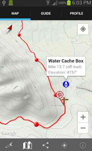
A bright red line indicates the location of the official CDT on the map. Popular alternate routes are indicated in blue and accompanied by a separate list of waypoints and elevation profile. Waypoints of interest to the hiker are plotted on the map. There are also markers on the map every mile or kilometer of the trail track.
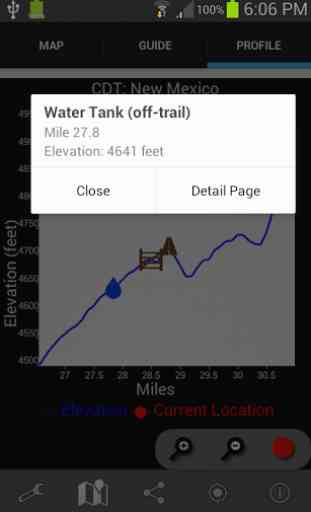
The elevation profile shows trail distance vs elevation and plots your current location on the trail. Each waypoint is plotted on the profile. Each waypoints is clickable, opening to the waypoint's detail page.
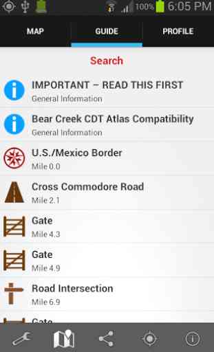
The guidebook lists every waypoint in order by distance along the trail.
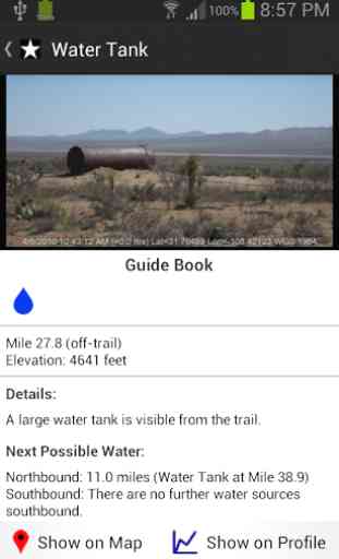
Each waypoint includes a detail page, providing further details about that particular waypoint. Details include the waypoint's mileage point and elevation, photographs of many of the waypoints, distance northbound and southbound to the next water source, a Trail Register where you may post comments and read other users' comments, and other details that will help you during your hike, and help you plan your hike.
The types of waypoints include:
-->Water sources-->Towns/post offices/services-->Trail junctions-->Parking areas along the trail-->Campgrounds, ranger stations-->Roads, railroad tracks, power lines, fences, gates-->Other Landmarks
Also available: Guthook's Guide to the Pacific Crest Trail (5-part series)Guthook's Guide to the Appalachian Trail (9-part guide to the Appalachian Trail)John Muir Trail HikerTahoe Rim Trail HikerMt. Whitney GuideVermont's Long Trail HikerGhost Ranch Guide
Category : Travel & Local
Reviews (29)
A very useful tool indeed! I keep my phone on and Guthook running all day on the Trail, and 99% of the time it's the only resource I use. I would have loved to have had this when I hiked in 07. Makes navigating a breeze. Heck, the water info alone makes this app worth having. If you're hitting the CDT do yourself a favor and download this!
the map is not consistent with the actual trail in many areas and im only 500 miles into my hike. there are serveral sections of trail that have changed years ago and the app isnt updated yet. Water sources are wrong. Mileage is off. I just wish they put the same effort into this trail map as the PCT and the AT
overall I LOVE the guthooks apps, they make thru-hiking so simple and bring tons kf useful information from hiker comments. The CDT app could use more campsite waypoints and more info on towns, many sleeping accommodations, restaurants, and other POI seemed tk have been left off. Also, the town mileages dont reverse when you change your direction to a sobo hike.
Very useful! However, compared to Guthook's PCT it has less data (no campsite waypoints) and is sometimes less accurate--sometimes missing miles, sometimes missing waypoints, things like that. Luckily there is a comment section where hikers can share relevant info.
Have used on AT, PCT, and now CDT. Invaluable on trail, but missing a key feature for planning. I could not find anyway to get the GPS coords for points on trail. It would be great if waypoints displayed GPS with elevation and trail mileage.
Great for finding and staying on the trail. All icons and info good, except for water sources. They are greatly outdated and not reliable in southern New Mexico. Just done all updates and it doesnt work at all!
It's great that it shows the new trail. And water sources. But it doesn't always show other road/trail near by. Last year I could leave trail comments now that option is gone.
It worked great last year, now it crashes every time i try to make a custom route or use it for a few minutes. 5 stars for lasts years performance, zero for current performance
Used guthooks on the PCT and it was awesome! Didnt get it for the AT but missed having the wealth of information. So downloaded this chappie and cant wait to give it a whirl, just wish it had the campsites on to give a goal for the day! Keep up the good work!!!
Has everything I need to plan the CDT. Some data needs to be linked better to the map, but it's miles better than anything else I've looked at.
Fantastic resource if you are thru or section hiking the CDT. Could use a few more features like the ability to make personal notes and waypoints that aren't shared with the global app community.
I used a version of this on the CT the app was great. Now I have this particular version as a slowly knock out sections of the CDT so far it is accurate and handy !
was super helpful on my 2018 thru-hike, Lately it hangs for a minute every time I try to view maps.
The app has allowed the navigationally challenged to venture out more safely!
It should say it cost $39.99 before you waste your time downloading it
Wouldn't hike the CDT without it!
Great app, good information
Maps, waypoints, and elevation profiles are great, but performance problems make the app virtually unusable. It took minutes whenever i tried to zoom or resize a map. I finally gave up and went back to my old GPS app which isn't cdt specific but is at least usable.
Its saved my life on trail and does it job of being a GPS well. But man, compared to the iPhone version this is ugly and crashes more. I cannot download the maps I want onto my galaxy s7, the feature always crashes.
Great for tricky trail junction and water resources. Doesn't seem to be a power hog on the phone.
Best map of the CDT available anywhere plus GPS. Hard to imagine how it could be better. Maybe if it also filtered water :)
Super helpful how hikers can comment on status of water sources. You can still use GPS on airplane mode and low battery mode.
Would be perfect if waypoint comments were updated with latest CDNST water report info so hikers know which water sources shown in app are probably now dry, important to survival!
It's an accurate and reliable mapping system that's going to make my hike 100 times safer. Thank you CDTC!
Would be awesome if it would tell me when I'm off trail/missed my turn.
This was perfect for the CDT. Thanks keeping me alive out there. Just buy this already. -Acorn
It uses old Bear Creek survey data. Doesn't show camp site. Accuracy needs improve.
Great app if you trust your phone you can use just this to navigate.
love this app! like many other atlas guides, it contains great information on town distances, water, trail distances, and allows for crowd sourcing of information. it also contains many alternates so you can truly choose your own adventure! atlas guides updates regularly and is receptive to users when contacted about things they'd like included in the app. App can be downloaded for back country use. love love love it!!