Guthook's JMT Guide
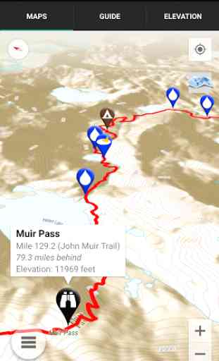
John Muir Trail Hiker use a combination of your phone's GPS, downloaded topo maps, and the Google Maps interface to accurately locate your position on the trail. No phone service? Not a problem -
- your phone's GPS pinpoints your location on top of topo maps downloaded as part of the app.
A bright red line indicates the location of the main trail on the map. Side trails are indicated in blue. Waypoints of interest to the hiker are plotted on the map. There are also markers on the map every mile or kilometer of the trail track.
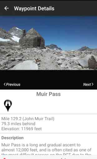
The elevation profile shows trail distance vs elevation and plots your current location on the trail. Each waypoint is plotted on the profile. Each waypoints is clickable, opening to the waypoint's detail page.
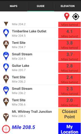
The guidebook lists every waypoint in order by distance along the trail.
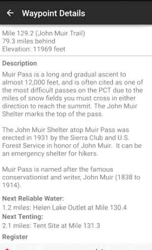
Each waypoint includes a detail page, providing further details about that particular waypoint. Details include the waypoint's mileage point and elevation, photographs of the waypoint, distance northbound and southbound to the next water source, a Trail Register where you may post comments and read other users' comments, and other details that will help you during your hike, and help you plan your hike.
The types of waypoints include:-->Water sources (including the reliability of each water source)-->Resupply locations-->Exit points-->Tenting sites/camping sites-->Trail junctions-->Parking areas along the trail-->Picnic areas, campgrounds, ranger stations-->Roads,fences, gates-->Natural landmarks, such as mountain passes and meadows-->Privies/restrooms-->Restaurants, stores, lodging-->Views
Side Trails:-Baxter Pass-Bear Ridge (to Lake Edison)-Bishop Pass-Blayney Meadows-Cascade Valley/Fish Valley Alternate-Charlotte Lake-Darwin Bench-Devils Postpile-Duck Pass-Edison Lake (to ferry and to Vermilion Valley Resort)-Evolution Crossing Alternate-Florence Lake Ferry-Half Dome-Isberg Pass Alternate-Kearsarge Pass (to Onion Valley)-Rainbow Falls (at Reds Meadow)-Mist Trail-Mount Whitney Trail-Muir Ranch-Pacific Crest Trail Alternate-Panorama Trail (to Glacier Peak Trailhead)-Piute Pass-Reds Meadow-Sawmill Pass-Shepherd Pass-Sunrise Lakes/Tenaya Lake Trailhead
Resupply Info:-Yosemite Village-Tuolumne Meadows-Lee Vining-Red's Meadow-Mammoth Lakes, CA-Vermillion Valley Resort-Muir Trail Ranch-Bishop, CA-Independence, CA-Lone Pine, CA
About the John Muir Trail: The John Muir Trail, or JMT, is revered as one of the most pristine and beautiful trails in the world. The 210.5 mile trail makes its way through the heart of the Sierra Nevada Range in Central California. Much of the trail is above 10,000 feet elevation and is quite steep, making this a rather difficult trail. Most hikers hike the JMT southbound, beginning at Happy Isles in Yosemite National Park, and ending at the summit of the highest peak in the "lower 48" -
- Mt. Whitney. It takes about 2-3 weeks to hike the entire trail (some hikers are faster, some are slower). Many hikers complete the entire trail in one go, and countless others enjoy hiking a few miles along the trail via the many remote side trails that branch off the JMT.
Also available:Guthook's Pacific Crest Trail GuideGuthook's Tahoe Rim Trail GuideMount Whitney Guide
Category : Travel & Local
Reviews (25)
Destination points were good but it did not list all available. Water sources were based on crossings but did not include those that were reasonably close to the trail.
I have used it consistently throughout our JMT hike. It's been a good gauge for distance, elevation gain, knowing where water sources are. Invaluable tool.
Great resource. Usually not necessary for mid or late summer travel but definitely nice to have, particularly for earlier season trips.
Must have for hiking the JMT or any section of it. Never used a map on my thru hike.
Used it on the JMT. Life saver!! Would never thru hike without it.
for some reason the mileage is in the 500-700 range? the trail is only 220 so I'm not sure there the 500 comes from. Is that the PCT?
made the entire trip safe and reliable
Fantastic app. Really took the guessing game out of thru hiking.
used it on JMT twice. Awesome
No better App for the JMT
Its works great for jmt nobo trail navigation, water sources, tent spots (though some camps are illegal). I had to refresh map for side trails often. Overall very happy with the app.
Used this app on my jmt thru hike from cottonwood pass nobo all the way to yosemite in 2017. Really helped me navigate through all of the snow this year and helped me plan for water and campsites (as long as they weren't frozen or snow covered). I would definitely recommend to anyone planning a JMT hike
Used this app for my JMT attempt 2018. Did not disappoint and gave me far more than I bargained for.
Essential. Easy. Saved me when I could not see the trail. Money well spent.
This app was a huge blessing on trail. It kept us on the snow covered paths. Definitely worth purchasing.
Amazing app! Helped me quite a few times on the JMT last year when snow was covering the trail for miles.
Guthook is the thru hikers choice.
It deletes the offline maps unexpectedly so you have to re-download them if you want to use them.
For knowing how long until next water, campsite, etc. This said, one should not rely on it exclusively, and many of Guthook's campsites are overused or out of compliance with FS regulations. Make sure you know what you're doing out there!
I had it working in offline mode at home before the trip. Guide looked great with campsites and water indicated on the trail. Then as I got close to Yosemite the map guide stopped loading and at best was a basic GPS device. I tried uninstalling and reinstalling, shutting phone off and on. It's much too buggy to rely on and a waste of $10
Facebook test post fails and crashes app. Also app optimization on my s6 edge plus flags this app as using a huge amount of battery and resources and to uninstall.
In July 2015 I hiked the JMT with my son. I purchased the app when we arrived at Reds Meadow. I noticed a fellow backpacker looking at his map on his phone......huh? Hmmm. Nice!! It was awesome! Absolutely worth the price. Worked flawlessly all the way to Whitney! I will DEFINITELY purchase the updated version as soon as I have planned our next JMT thru hike! Mike+Mike on the JMT!!
Very helpful on the trail!
Trail map for use on your cell phone. Using a solar charging system, I kept my phone charged so I could use this guide. It is very accurate. The only time we had a problem was when the guide said there was water at mile 200 near the camp site. We had to go an additional 4 miles to find a good water source near a camp site which was at Crabtree Meadows. Or go back about 2 miles to a large creek. It appeared that there was water at mile 200 previously. This is a great app to use while hiking the JMT.
Just a Great App. I used it for the Tahoe Rim Trail. With user input and updates, you can go confidently into the wilderness and know you'll have water and camp sites. I've used it when I found myself inadvertently off trail to help me get back on it. At the airport right now, headed to the JMT with confidence