Guthook's Long Trail Guide
Guthook's Long Trail Guide is a detailed, map-based smartphone guide for your hike on the 270-mile Long Trail. It maps and lists more than 500 important hiker waypoints along the LT such as water sources, shelters, tenting sites, road crossings, resupply locations, and may others.
Key features:
- No mobile or internet connection is required after initial setup -- works in Airplane Mode
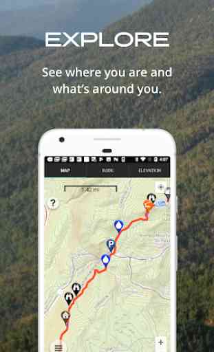
- Detailed maps with your GPS location
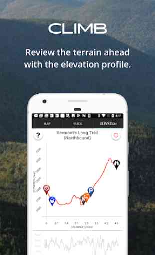
- Elevation profile view
- Custom route creator
- Multiple offline map choices
- Real-time comments from other hikers
- Send your current location to friends or family via text message or email
The guidebook lists every waypoint in order by distance along the trail and how far away you are from each waypoint. The guidebook also includes a detailed town guide for major resupply points, towns, and services along the Long Trail.
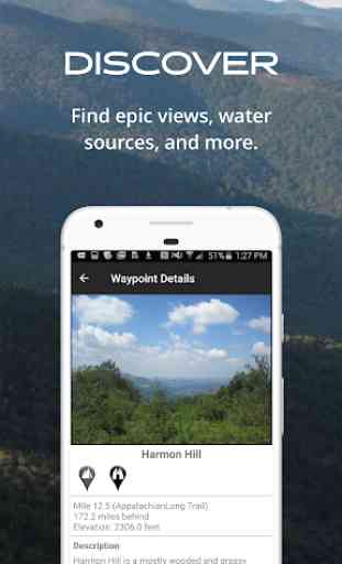
Waypoint details include:
- Mileage point and elevation
- Photographs
- Distance to the next water source and tent site
- Comments section where you may post comments and read other hikers’ comments
Types of waypoints:
- Water sources (including the reliability of each water source)
- Detailed resupply and town information:
- post offices and other package services
- restaurants
- grocery stores and convenience stores
- gear shops and hardware stores
- laundromats
- lodging, public showers, public restrooms
- public libraries
- Tenting sites/camping sites
- Trail junctions
- Parking areas along the trail
- Picnic areas, campgrounds, ranger stations
- Roads, railroad tracks, power lines, fences, gates
- Natural landmarks (e.g. mountain passes)
- Privies/restrooms
- Views
About the Long Trail*: The Long Trail, or LT, is the original and oldest long distance hiking trail in the United States. The 273-mile trail crosses south-to-north through the state of Vermont along the Green Mountains, from the Massachusetts border to the Canada border. The first 107 miles of the trail overlaps the famous Appalachian Trail. Countless hikers enjoy hiking anywhere from a few miles to the entire trail each year.
*"Long Trail" is a registered trademark of the Green Mountain Clu
Category : Travel & Local
Reviews (20)
Worked great for our thru-hike and gave us a lot of peace of mind. My phone lasted forever on airplane mode and battery saver, and checking this a few times a day barely put a dent in it. We had the paper map as well but mostly used that to get an overview of the elevation, for comparison purposes. We recommended Guthook to a friend who started his thru-hike after us and he was excited!
The creator is my angel. He happened to have passed by me the day my hiking partner got sick and we ended up hiking slowly and into the night on a really overgrown part of the trail. We got separated, I got lost, she ran out of water. I was a mess until I remembered the name of the app and $9 is absolutely worth it. Saved me in so many ways.
This app helped me stay informed about water sources and camp spots during my first solo backpacking trip. It made me feel more relaxed. The comments from other hikers make it invaluable.
Great app! it has excellent detail and the ability to get on the ground updats from other hikers.
Unless you are an expert hiker who instinctively knows the trails inside and out you'd be irresponsible to go without this app.
Maps won't load for any of the 3 Guthook apps I've installed. Everything was working fine 2 weeks ago.
Sometimes bugs in long, other then that great app
Super informative. Great resource
this app is all you will need!!
While AWOL's AT Guide is still my go to, Guthook's guide fills in the holes. It's a great guide and likely would be equivalent to the Guide if you started using it exclusively. Good stuff.
Used this app for hikes on CT, LT, and southern PCT. Wouldn't go without it. Especially helpful for water on the LT and camping spots on the CT. But always have a paper map backup. Works with phone on airplane and battery saver mode. ....
I've been using this app for section hikes since 2014. Great resource, and excellent service response!
Great App. I just wish it included town info like the PCT and AT versions.
Great app. Wish you could adjust the vertical range.
Used it twice and works great.
This is a must have.
Saved my bacon on the LT
Can't say enough good things about this app. Absolutely the best cell phone gps app ever made. Very good battery life. Very accurate and first rate information. You can trust it.
Just thru hiked the LT with this guide. This is a must have! Absolutely perfect app. LOVED IT! Never wanna hike without Guthooks guides again. Great work and please keep it up!!! Totally worth the $!!!
Fantastic APP! The LT is not marked as well as the AT and there were a few times that I was able to identify that I was off trail using the APP. The Map function is very useful for identifying where you are relative to your mileage objective. The Elevation function is great to let you know what kind of slope you are approaching and the elevation gain/loss you are approaching. The Guide function provides valuable information about places on and near the trail that help in planning.