Guthook's PCT Guide
NO PHONE OR INTERNET SERVICE IS REQUIRED to use Guthook's Guides after the initial setup. Guthook's Guides use a combination of your smartphone's GPS, downloaded topo maps, and the Google Maps interface to accurately locate your position on the trail. Your phone's GPS pinpoints your location on the downloaded topo maps.
The free demo covers the 43 mile portion in Southern California from the U.S./Mexico Border to Mt. Laguna. The demo is fully function with all features of the paid version. In-app purchases include guides for Southern California, Central California (Sierra), Northern California, Oregon, and Washington. There are also in-app purchases available for the John Muir Trail, the Mount Whitney Trail and the Wonderland Trail.
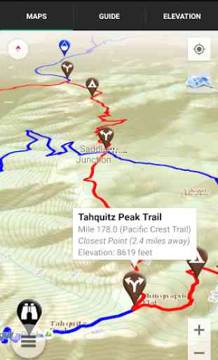
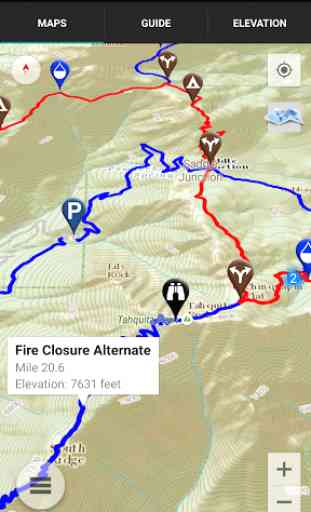
A bright red line indicates the location of the main trail on the map. Side spurs to water sources or other points of interest are indicated in blue. Waypoints of interest to the hiker are plotted on the map. There are also markers on the map every mile or kilometer of the trail track.
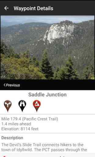
The elevation profile shows trail distance vs elevation and plots your current location on the trail. Each waypoint is plotted on the profile. Each waypoints is clickable, opening to the waypoint's detail page.
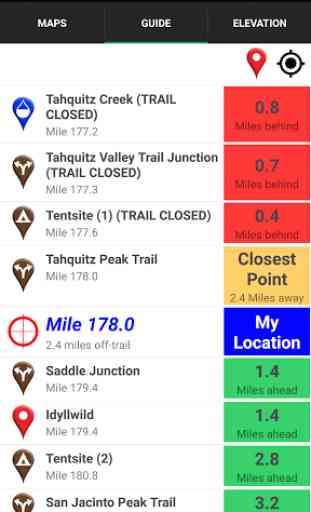
The guidebook lists every waypoint in order by distance along the trail and how far away you are from each waypoint. The guidebook also includes a detailed town guide for major resupply points and towns along the PCT.
Send your current location to friends and family via text message or e-mail.
Each waypoint includes a detail page, providing further details about that particular waypoint. Details include the waypoint's mileage point and elevation, photographs of the waypoint, distance northbound and southbound to the next water source and tent site, a Trail Register where you may post comments and read other users' comments, and other details that will help you during your hike, and help you plan your hike.
The types of waypoints include:
-->Water sources (including the reliability of each water source)-->Detailed resupply and town information----->post offices and other package services----->restaurants----->grocery stores and convenience stores----->gear shops and hardware stores----->laundromats----->lodging, public showers, public restrooms----->public libraries----->movie theaters-->Tenting sites/camping sites-->Trail junctions-->Parking areas along the trail-->Picnic areas, campgrounds, ranger stations-->Roads, railroad tracks, power lines, fences, gates-->Natural landmarks (e.g. mountain passes)-->Privies/restrooms-->Views
About the Pacific Crest Trail: The Pacific Crest Trail, or PCT, is the longest completed trail in the world at 2,650 miles. The trail begins at the U.S./Mexico border near Campo, California, and winds its way through California, Oregon and Washington to its northern terminus at the U.S./Canada border near Manning Park in British Columbia, Canada. Many hikers complete the entire trail in one season ("thru-hikers"), and countless others enjoy hiking anywhere from a few miles to hundreds of miles each year.
Pacific Crest Trail, PCT, Pacific Coast Trail
Category : Travel & Local
Reviews (27)
This app is invaluable while hiking the PCT. I gave it two stars, though because the Android version is vastly inferior to the iPhone version and crashes on my several times a day in addition to the constant lag as I'm navigating it. Little unacceptable for a paid app, one would think....
Original and still the best.! Tried the Guthooks Guides and came back to old reliable. minus one star due to routing issues with the Sierra section (causes force close ) but the app does recover. Guthooks guides app will endless force close after a custom route failure, becoming a useless app that can't launch. if you are at home the Guthooks guides App is great. On the trail use Guthooks PCT app ...you have been warned!
A very reliable and consistently useful navigational app. for PCT travel. Also a source of amusement from time to time, depending on the commentery, observations, and responses submitted by users as comments attached to specific points along the trail route. Well built and easy to use.
Guthook's guide to the PCT is almost required of PCT hikers these days and super helpful at seeing the trail and choosing where to camp. Only complaint is that it's not the greatest at showing you how to get back to the trail if you are so unlucky as to take a wrong turn.
On one hand, an intrusion on the wilderness experience, but on the other hand is so darn helpful that this app is indispensable. Has forever changed long distance hiking.
I purchased the western hiker special for $45. It looks now like this deal does not exist, and cannot be purchased, at least I don't see it anywhere. It originally included the entire PCT along with tahoe rim and wonderland, yet, now I cannot access the pct guide for any of the sections, even though I could before. Wondering if perhaps this is because they got rid of this deal, and it somehow affected the current western special owners as well? Let me know what could be wrong here. Thanks
Awesome app for all users of the PCT! If you want to have current information and reviews and be able to upload your own reviews on any place on the trail, and never get lost download this app. It is the only thing you need to successfully navigate the PCT. Being able to see updated info on stream flows and water caches as well as great advice that hikers ahead of you have posted is absolutely priceless. This app is what is known as a lifesaver.
Well worth the money. Can pretty much be used as an exclusive for map on the trail. Great UI, and downloadable features, and comments on waypoints are great.
great but obnoxious on android. tells me everything i want to know, though it doesn't include all camp spots or water, but It crashes or wont respond lioe 50% of the time on android, and seems even worse when i have to restart.
Had gutthooks for 2 thruhikes. Planning to section hike. Every time I try to use the app it takes 5 mins to search for updates. In airplane mode or areas without signal this is going to be a major problem.
So, this update makes everything so much more difficult. The elevation doesn't have an option to see find where you are like it used to. I don't really get the social media aspect, but maybe that is just not for me
If you want to do some serious hiking, but don't want to completely rough it by using ONLY paper maps (always have a backup), this is a must. Got me back on trail out on the PCT in 2018.
Absolute life saver. I run it on an android. Last year I spoke with another hiker while on the PCT he was having issues when using apples platform. I'm sure apple has worked it out by now. Great resource for finding water and camp sites. Cheers and happy trails
I'm only rating this because of the excellent support they provided me. I have used guthooks from the AT to the PCT and was pleasantly surprised that they got me up and running after a minor issue that normally wouldn't have been cared for by other companies.
Just completed 266 miles of of the PCT. Guthook's made it possible. You can always make your way back on trail when in doubt. Also, water updates from fellow hikers is fantastic.
Excellent resource for all PCT thru and section hikers. All points-of-interest with descriptions and directions present and accounted for. Essential app.
Can't get the GPS compass arrow to turn me towards the trail when lost in snow (or at Mission Creek for example). Works on google maps, All trails but never in GH. How do I fix this?
my experience is, that this app is extremely helpful. would use it all the time. preplanning the day on the trail. 👌👍
If you are thru-hiking or section-hiking the PCT, this is the app to have. It shows you the latest water information and where all the tentsites are and how far you are from them. This is the most popular guide app on the trail!
I've used this app extensively over the last 4 years. Was definitely the go to during the massive snow pack in 2017 in the sierras.
They don't maintain it. Bad/stale data, poor ux/ui, lack of features, and quite buggy.
Once you understand how it works it becomes easier. So very helpful to find water and mileage and other people's comments on the sites are valuable.
Great info and setup, but constantly crashes when trying to change between sections without signal
Some of the descriptions are a bit outdated by this point but the comments generally clear up any problems. Must have if you want to hike the PCT!
Indispensable for PCT. Though they do delete comments and updates on important points for some reason. Hope it's not political. Overall a great app.
Indispensable on the trail, with readings updating your exact distance to next waypoint, accurate and up-to-date reports about the existence of water at your next source, helpful photos and comments of what to expect.
Used to be great. Now just ok. It constantly switches between map and satellite image as you zoom in and out and there's no regularity in it whatsoever. You never know if it'll be map or satellite and it flashes back and forth. Om honestly not going to use guthook anymore. Every year there's a new issue and this one takes the cake. STOP DOING UNNECESSARY UPDATES!!!! GET A DIFFERENT HOBBY AND LEAVE WELL ENOUGH ALONE