Guthook's Tahoe Rim Trail
Guthook's Guide to the Tahoe Rim Trail is a smartphone guide for your hike or mountain bike ride on the Tahoe Rim Trail. The app uses a combination of your phone's GPS, downloaded topo maps, and the Google Maps interface to accurately locate your position on the trail. No phone service? Not a problem -
- your phone's GPS pinpoints your location on top of topo maps downloaded as part of the app.
The trail is color coded according to allowed use for hikers, horses and bikers. An elevation profile of the Tahoe Rim Trail is displayed in the Profile tab of the app. It shows you the elevation of the trail plotted against distance along with your current location on the trail.
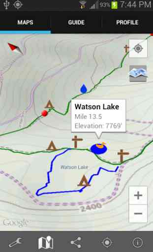
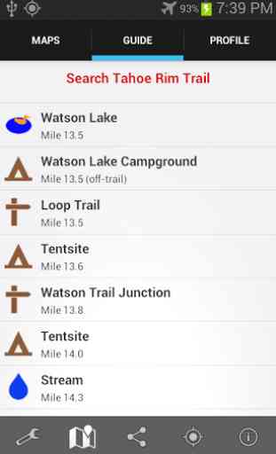
Over 500 waypoints along the 173-mile Tahoe Rim Trail are displayed both on the map and in the "Guide" tab of the app. (The demo has 56 waypoints along 20.3 miles.) A Trail Register allows you to post comments about any waypoint and view other hikers' comments. This feature can be helpful, for instance, to obtain information about upcoming water sources.
The types of waypoints in the full version of the app include:
-->Trailheads and parking information-->Water sources (including the reliability of each water source)-->Tenting sites/camping sites-->Lake Tahoe views and other views-->Trail junctions-->Picnic areas, campgrounds-->Paved and dirt roads-->Other Landmarks-->Privies/restrooms-->Restaurants, stores, lodging
There are also markers on the map every mile of the trail track.
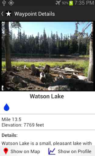
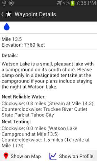
Clicking on a waypoint on either the Map or in the Guide opens a detail page for the waypoint, providing further details about that particular waypoint. Details include the waypoint's mileage point and elevation, photographs of the waypoint, distance to the next reliable water source, a Trail Register where you may post comments and read other users' comments, and other details that will help you during your hike, and help you plan your hike.
About the Tahoe Rim Trail: The Tahoe Rim Trail is a 173-mile trail that circles beautiful Lake Tahoe in the Sierra Nevada mountain range. The trail passes through California (113.5 miles) and Nevada (59.5 miles). 50 miles of the trail overlap the Pacific Crest Trail and 31 miles overlap the Tahoe-Yosemite Trail. The trail is broken into 8 sections, ranging from 17 miles to 32 miles each. Many hikers complete the entire Tahoe Rim Trail all at once while others complete the trail section by section. Countless others enjoy day-hiking and mountain biking the trail.
Also available from High Sierra Attitude, LLC: Guthook's Guide to the PCT (5-part guide to the Pacific Crest Trail)Guthook's Guide to the CDT (5-part guide to the Continental Divide Trail)Guthook's Guide to the AT (9-part guide to the Appalachian Trail)Guthook's Guide to the John Muir TrailMt. Whitney GuideThe Colorado Trail HikerVermont's Long Trail HikerTrailblazer's South Downs Way (UK National Trail)
Category : Travel & Local
Reviews (14)
Thru-hiked the trail July 2020 -the app was fantastic. I really loved the ability to see comments from other hikers as to the current status of water, campsites, etc.
Just the best app for doing section or through hiking of this trail. Made by backpackers for backpackers.
Not stable. When creating a route it crashes.
Super helpful, but would love info on potential campsites.
This is a better version then the new Guthooks app. How can I use my purchase on the older FAR BETTER VERSION.
Great info. Was able to get a map for the section I'm hiking.
Love knowing where the water is at!
I used this app in 2014 to hike the entire 173 mile Tahoe Rim Trail. At the end of June there were still several massive snowfields that had to be navigated and this App was literally a lifesaver. Several other people without this tool using paper maps had to turn around in some situations, where my friend and I were able to break through the snow fields and continue our journey...
When I bought it, I loved it. Eventually, they did away with the convenient mile markers. Now they've done away with the tent sites. What's next? It's still good. Just not as good as it used to be.
Nice app! Offline download avail. But needs more trails!
Love, love, love this app!
I purchased this app to use during my July 2015 thru hike of the TRT and I was very impressed with the functionality. It worked just as advertised and I consider it $6 well spent. I found myself using it several times a day just to check my progress, distance to various waypoints, etc... I'm an old school guy and I will continue to carry my compass and paper maps, but I can honestly say that having this app adds to my sense of security on the trail and is great fun to use as well. The only negative I can come up with is that the app seemed to sometimes get a bit confused momentarily when repositioning my android phone from landscape to portrait orientation or vice versa. Not a big deal, but maybe something for the developer to consider in a future upgrade.
Very useful app for hiking the Tahoe Rim Trail. The GPS feature is spot on for navigation, and the water sources shown are indespensible. Users can update water sources as they find them, so hikers now what to expect.
Had some trouble with the app not displaying important information but the support team responded really quickly and got the issue resolved for me. Turned out I just had to uninstall and reinstall the app. I also have their PCT app which is even better. I highly recommend this app.