Halfmile's PCT
- think of it as a very accurate, location aware, digital PCT Data Book.
Other features of the app include:
* Works without cell phone service
* Download and Go -
- no extra configuration or data needed
* Simulation mode for hike planning and hiker support
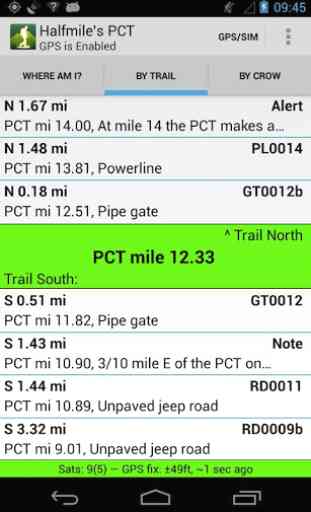
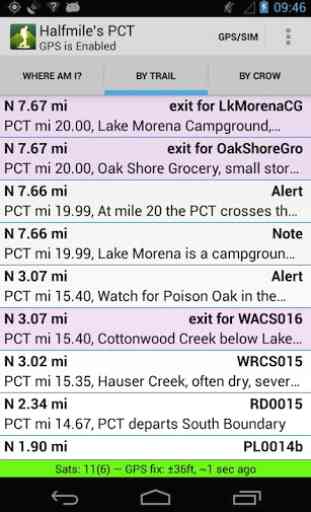
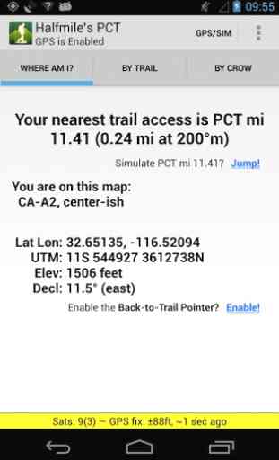
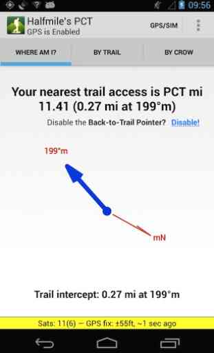
* Provides specific "how to walk there" instructions for all points
* Calculates cumulative elevation gains and losses to all points
* Powerful search function for features like water sources, campsites, and resupply locations
* Calculates which printed map pages contain your location
* Matches the data and calculations of the iPhone edition exactly
The Pacific Crest Trail is a 2,650 mile National Scenic Trail thatruns from Mexico to Canada through California, Oregon and Washington.
Category : Travel & Local
Reviews (27)
I hiked 1000 miles with this app and it was the only guide I needed. Never steered me wrong!
I hiked 1,700 miles with this app. I totally recomend it. I did not need anything else.
needs updated info but otherwise works like a charm
Must have app for through and day hikers
The de facto standard for PCT navigation these days. Everybody hiking the PCT should use this. That said, the interface takes a lot of getting used to -- so much so, that people often take wrong turns due to its unintuitive UI (especially how it displays side-trails on the main trail).
Wow. Just wow. After 2 days, I never opened my paper maps again. This app is truly amazing. An absolute MUST for thru hikers. Especially those of us that only carry enough water to get to the next watering hole. I would suggest adding a feature that allow users to submit comments at way points, such as how many tent pads at campsites, if water has dried up, if there are bugs, etc. Also, how can I donate? This app is definitely worth money.
This app is fantastic. The simplicity actually makes things easier once you get used to it. I used it in 2017 for Section L into Canada and absolutely loved it. Why the 3 stars? This hasn't been updated with the 2018 mileage, so it doesn't match the latest half mile paper maps. Not a huge deal, but it is confusing when planning with both to determine distance and elevation between sites. After a certain area, this will be off by 2.5 miles.
Perfect for when you're on the trail or planning your next trip. Whether you just section hiking or your thru hiking the PCT, this app is a must.
A must for the PCT traveler. Contains essential trail and wayfinding data, and complements the electronic or paper maps you carry. Thank you Halfmile!!!
Oregon resident for 65 years. Avid outdoorsman. I have used halfmile and halfmile/google earth on solo wilderness outings and group outings. People are very thankful when i show them the apps and how to use them. Cool, very cool!
More accurate than maps. The pointer back to trail in heavy snow pack is awesome.
Unbelievably helpful. Has made walking the PCT a safer and more understandable experience.
The best real-time coordinate tracker I've found. Don't travel the PCT without it. Very accurate water and resupply data.
If you have plans to hike, this App.will show you all the trails where you'd like to go,and do everything but put your feet in gear!! Great app I can't leave home without it
My friend and I just hiked between Chinook pass and White pass on the PCT. This app was an awsome tool to tell us where our next water source was and how far to the next waypoint. Also kept us on the right path.
Phones break and batteries die so I wouldn't throw out the guide book but if you are carrying a phone I can't think of any reason not to have this app.
A great backup to the paper maps. Love it. You can't beat the price. Thanks.
I used this for my entire thru hike and will do it again.
The best app ever. Accurate and extremely helpful
Like this app. Use it for section hike on the pct. Planing on taking it on my through hike.
Thank you for making this app free!!!
Best!
It does what it advertises to a tee
This app is a must for the novice and experienced. Getting ready to use the 2015 update on PCT hike next month.
I used the iOS version of this app in 2012, and it was my primary navigation aid. This app understands what information PCT hikers want and need more than any other app I've seen.
Used this app exclusively for navigation/info on my 2014 hike. Very reliable, conservative information. Must have if you are hiking the pct!
This is an excellent app for thruhiking or section hiking the pct. Yes, SOME stuff is out of date (such as reroutes or resupply spots) but overall it's still an excellent resource to have.