Handy GPS
This app is a real navigation tool designed for outdoors sports like hiking, bushwalking, mountain biking, kayaking and trail riding. It is also well suited to uses like mining, forestry, and archaeology. Its simple to use and works even in the remotest back country since it doesn't need network connectivity. It allows you to work in UTM or lat/lon coordinates so you can use it with your paper topographic maps. Waypoints and track logs recorded in the field can be be viewed later in Google Earth.
BASE FEATURES:
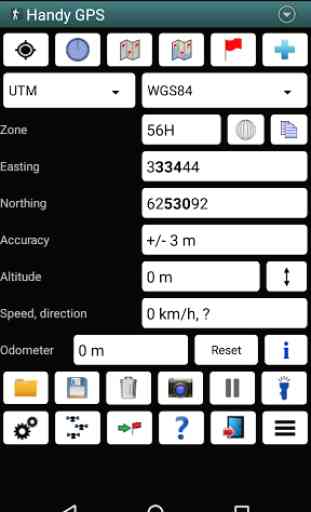
* Shows current location in easting/northing (UTM) or lat/lon
* Shows speed, direction of travel, distance travelled in either metric or imperial/US units
* Can store current location as a waypoint, and can store track logs
* Waypoints and track logs can be imported from and exported to Google Earth KML and GPX files
* Allows manual entry of waypoint coordinates in UTM, MGRS or lat/lon
* Custom waypoint symbols
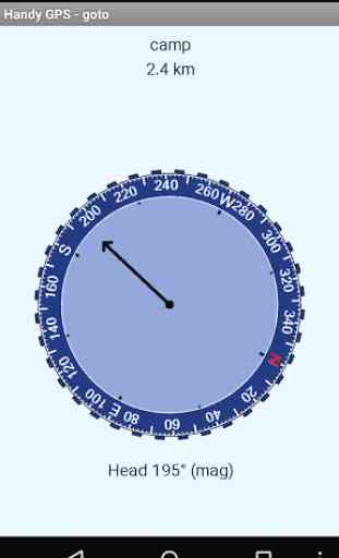
* Can guide you to a waypoint with the "Goto" screen, with optional audible proximity alert
* Has magnetic compass page (devices with mag sensors only)
* Computes local magnetic declination and geoid correction at startup using the IGRF-12 and EGM96 models
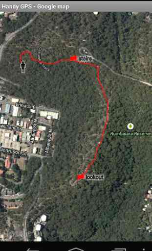
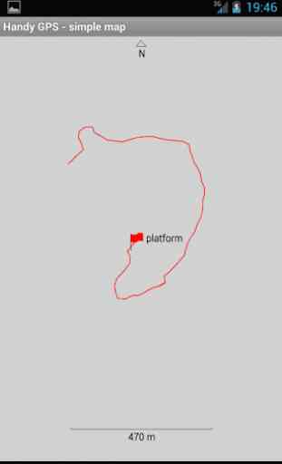
* Can display either a simple map of your current location and the stored waypoints, or a Google Map
* Supports the world-wide WGS84 datum along with the Australian datums AGD66, AGD84, GDA94. (You can also use WGS84 for NAD83 maps)
* Shows satellite locations and signal strengths graphically
* Can display simple 6, 8 or 10 digit grid refs, or MGRS grid ref.
* Waypoint-to-waypoint distance and direction
* Optional timer to record walk duration and compute average speed
* Can be used instead of "MyTracks" app
* Thoroughly tested by developer on many off-track walks
EXTRA FEATURES IN THIS VERSION:
* Unlimited number of waypoints and track log points. (Free version limited to 3 waypoints and 20 tracklog points)
* Email or SMS containing a clickable link showing your location can be sent to a friend.
* Common datums such as NAD83 (US), OSGB36 (UK), NZTM2000 (NZ), SAD69 (South America) and ED50 (Europe) can be selected from the custom datum page, or you can configure your own datums, including local grid systems (such as those used at mine sites). You can also load and save datum params.
* UK grid refs with two letter prefixes can be shown if OSGB datum selected. OSGB grid refs can also be shown on smartwatches.
* Elevation profile of your route can be shown.
* Average GPS locations over time to give more accurate result.
* Take photos from the app which are optionally geotagged, or have the location "burnt" into image.
* Show sun rise and set times.
* Export waypoints to CSV file in current coordinate system.
* Create a new waypoint by projecting an existing one using an entered distance and bearing.
* Compute length, area, and elevation change for tracklog.
* Offline map support by downloading tiles from map tile servers, or using your own map images.
* Comes complete with an Android Wear version for use on your Android Wear smartwatch.
PERMISSIONS: (1) GPS
- to determine your location, (2) Network access
- for access to Google Map and OSM tiles, (3) SD card access
- to load and store waypoints and tracklogs, (4) Camera access for taking pics, (5) Prevent phone from sleeping so that proximity alarm works, (6) Control flashlight, to allow the flashlight to be turned on/off from within the app, and (7) System settings, to allow the Android Wear app to control the watch screen brightness.
DISCLAIMER: You use this app at your own risk. The developer accepts no responsibility for you getting lost as a result of using this app. Batteries in mobile devices can go flat. An alternate power source is recommended for extended hikes.
See the Coordinate Master app for support for more coordinate systems. Handy GPS is also available for iPhone and Windows Phone.
Category : Sports
Reviews (25)
A professionally detailed GPS app. It has everything required for a safe trek home. The video is well presented and email support by Anthony Dunk absolutely brilliant ... Would I recommend this app? A resounding definite and absolute YES👍
Always been accurate. Great for displaying impressive results of a day out hiking when overlaid with a satellite image.
Takes getting used to...I don't think there is smart phone support for Garmin Fenix 3 as I checked the IQ connect store and it didn't have Handy GPS listed.
sweet and easy love it and recommend it. free version is good, paid version is great. good on or off road and i drive a wrangler so i know. even lets me save unmarked trails that I've traveled. two thumbs up. i haven't gotten lost yet so that's got to be a plus. i enjoy it hope you do too.
Great for navigating to way points. Can easily import and export kmz files from Google Earth. I have checked the saved coordinates with a differential GPS unit and Handy GPS was accurate to about 0.5m.
I'm using Samsung Galaxy S5 but whenever I want to mark a waypoint, my accuracy has never gone below 10ft. apart from that I'm enjoying every bit of the paid version . great app
This is a great app that I use regularly. Support is excellent. I reported a problem I encountered with v37.4 and an update with a fix was posted in hours.
Best app of its type. Brilliant for bushwalking. Simple and no fuss to use with plenty of features available if required.
Absolutely brilliant, I've used various GPS devices and tried several apps, this does everything I want for bush walking and four wheel driving.
Greas simple GPS plotter. The zoom on simple map is too agressive though if you have waypoints very far apart. Is there an app to link to Samsung Gear Sport watch?
This app is awesome, but please update to enable us to save in .shp format. Well developed and for you who still considering to choose gps app for phone do not hesitate to download this
I purchased the app but it didn't download, i have tried the solutions provided by Google play and it didn't work.
My app is still not yet installed. I'm hoping for the installation to be done to experience it's working.
It is a very good and handy app for fast and detailed field work. Thank you hadygps team.
Hi I have subscribed with payment. Due to my phone problem all data lost. Now its asking to pay again. Please do needful.
Great app for hiking and biking, with more detail available as needed.
Doesn't work, just asks for permissions but has all the permissions allowed already
was good enough then they updated changed completely and deleted my waypoints
its great and easy to use
how do i download gps waypoints from my email address it works easy on iphone but cant seem to get it to work on android phones
Very useful during field surveys
This app is a life saver. I wouldn't leave home without it.
How to calculate the area between waypoints?
Very usefull for survay feild
I've been using this for years for backcountry navigation with compass backup, haven't run across something better, though I browse occasionally. Straightforward gps app, easy navigation and easy to export data. Defaults to satellite imagery which is fine. Load the maps while you have a signal though, if you're using it backcountry.