i-Boating:Marine& Fishing Maps
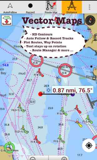
►FEATURES√ Download Beautiful & detailed Hardware/GPU accelerated vector charts (text stays upright on rotation)√ Query details of Maritime object (Buoy, Lights, Obstruction etc).√ Custom depth(Ft/Fathom/Meter) & distance units (km/mi/NM)√ Custom depth shading (safety depth).√ Record tracks, Autofollow with real-time track overlay√ Voice Prompts for marine navigation (requires GPS )√ 1ft / 3ft depth contour maps for anglers for selected lake maps. Useful for fishing/trolling(freshwater/saltwater).√ Supports GPX/KML for boating route editing/import.√ Tide & Currents.√ Seamless chart quilting. Map details from Coastal, Approaches,Harbour, Inland Encs(rivers), and general ENC (Electronic Marine Charts) mapped to right zoom√ Enter/import Waypoints.
► MAPSGet all the details that you find in your chartplotters!Includes unlimited updates for 1 year.USA: Maps incl coverage of all NOAA ENC,USACE inland river maps & freshwater lake fishing maps for more than 7K lakes. Charts include HD/1ft/3ft bathymetry where available. Also incl NOAA raster charts for areas where NOAA ENC coverage isn't available.Canada: CHS data including rasters for some regions. Incl Great lakes(US & Canada sides),Alberta & Ontario lakes,Lake Simcoe&Trent Severn Canal.UK/Ireland: UKHO chartsGermany:BSH charts,Waterways & rivers.FranceEurope Inland Rivers:Donau/Danube/Dunaja,Rhine,Rhein,Garonne,Moselle,Drava,SavaAustraliaNetherland/HollandCroatiaFinlandNorwaySwedenRussiaUkraine(Black Sea)BrazilSpainMalta, Cypress & Mediterranean SeaCaribbeanNew ZealandDenmark,Greenland,FaroeSeychelles,Mauritius,TanzaniaFalklandsMalaysia, South China SeaPersian/Arabian Gulf,Red SeaSouth AfricaArgentinaIcelandFijiEstonia,Latvia,Poland,LithuaniaTurkey,Greece,Italy
►Instrumentation√ Marine AIS & (NMEA AIS and GPS over TCP/UDP)√ Wind direction & Speed,Sonar depth,Water temperature
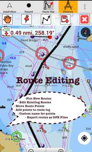
►ROUTE MANAGEMENT / TRIP PLANNING√ Create/Edit/Reverse Routes√ Waypoints mgt√ Import GPX, KML & KMZ files√ Share/Export Routes,Tracks&Markers
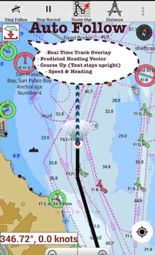
►GPS FEATURES√ Auto Follow
* Real Time Overlay
* Predicted Path Vector
* Course Up
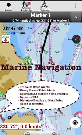
* Speed & Heading√ Route Assistance With Voice Prompts
* Prompts on approaching boating route marker
* Continuous distance & ETA updates
* Alerts when sailing/boating off route/wrong direction.√ Record Tracks►TIDE & CURRENTS
* US,Canada,UK,Germany&New Zealand
* High/Low Tides
* Tidal Current Prediction
* Active Current Stations► SHARING
* Social Sharing of tracks/routes/markers
* Export GPX files.► Change background to Satellite Imagery ► USA Fishing Maps
* Texas Lake Texoma,Eufaula,Toledo Bend
* Florida Lake Okeechobee, Kissimmee
* Minnesota Lake Minnetonka,Waconia,Leech,Mille Lacs
* Massachussets lakes Quabbin
* Ohio Fishing maps of Lake hoover
* Wisconsin Lake Winnebago, Pepin
* Utah Lake Powell, Bear
* Maine Lake Sebago
* Alaska Lake Winnipesaukee
* Tennessee Lake Barkley,Norris,Watts Bar
* South Carolina Lake Keowee,Hartwell,Murray
* Lake Michigan,Huron,Ontario,Superior,Erie► Canada Fishing Maps
* Lac Saint Jean
* Fishing maps of Ontario Lakes
* Rideau Canal-Ottawa River
* British Columbia
* Pacific Coast-Vancouver
- Haida Gwaii
* Nova Scotia South
- Bay of Fundy
* Quebec to Anticosti Island
* Newfoundland
* St. Lawrence river
* Manitoba&Saskatchewan
* Georgian Bay*Puget Sound► UK Fishing Maps
* Scotland
* Thames Estuary
* Ireland► Australia fishing Maps
* NSW South West Rocks
* Queensland Hervy Bay
Category : Travel & Local
Reviews (28)
This app is pretty good. The only downfall is you have to pay $20/year to continue to see the information you have input. Yes, $20 is nit a lot, but it's only used during boating season and not all year. I would like it to give directions between points, too.
Auto routing upgrade is fantastic. It does actually work. Easy to change the draft to see where the shallows are.
Been playing with automatic boat routing. I like it so far. Does a good job routing around the shallows. Changing the boat draft does change the route. I am happy that it actually works.
As detailed as you want or as simple as you want excellent sounding for depth very accurate. I use it in poole best app for visual and easy to set a route.
Very decieving...thought I was buying maps for Canada and the US but can only get 1 grid area and the 1 big lake I'm looking for is not available. I chose the option to download the app to my laptop, but the only option available was my LG tablet.
App doesn't work and I spent $50 trying to "update" maps so I could get off the hamster wheel of telling me to upload maps and then telling me my maps were out of date. Save yourself the frustration.
I contacted customer support recently regarding getting a night mode added to the app. I was pleasantly surprised to hear from them today that its been added.
The charts are lacking in showing depths and contours compared to the paper charts I am use to using many years ago.
I use it pretty much everyday without cellular signal. I have it on a phone with no sim. It works well.
Marine navigation charts respond very well to touch and super easy to use.
Teamed up with my friend recently for a fishing tournament. He introduced me to this lake depth maps app. Very useful to get a general idea of where the shallows and humps are. Used it to plan our strategy before the tournament.
Our marine GPS is very old and has old charts. This app is very handy and is a good substitute.
Can be a little off on accuracy sometimes but overall an amazing app. Caught 10x more fish than the average angler at a lake trout tournament because of this app
Like this charting app,.let's me download charts and plot courses while offline. Works on both my phone and tablet.
Moderately useful, but interface stinks and has no useful features.
Been boating for a long time using many chart apps but none have the detail like i-Boating. Thanks to the team who put this together. No adds is important.
App works great, has tons of lakes and is pretty accurate (most of the time). I would give 5 stars if it had maps/depths of all the lakes I fish. Missing some smaller lakes and even some bigger lakes. Hopefully my $31 goes towards some updates
If you are going to fish a new lake, it's a must have. Underwater contours are very helpful in identifying potential fishing spots.
Our boat's NMEA network is setup to stream all GPS and AIS data over UDP. It was very easy to hook this app to it. Now we get GPS and AIS on all our devices on the boat.
Great app. Enjoy the depths, tides and winds also. Very easy to use.
The new tide & currents update is very useful. Finally can view the graphs.
Great app. Got a quick/helpful reply when I got a new phone and lost my access to the paid version.
Cost effective atlas for lake depth maps. Used to have paper version for this. But its all electronic now.
I haven't been able to get the app working as well as pre-update. Seems much less intuitive
Purchased it last year and now I have to again? It doesn't state its an annual subscription.
Tech support was prompt in responding to all my queries. Appreciate the support.
I liked the application after the trial so I bought the Greek map. I had serious problem with the application but it was solved in 2 hours after an email I sent them. Now I can enjoy it. Thank you for the fast respond
I've just downloaded and launched your app on my devices. The app is very fluent and the vector charts seem very clear. Nevertheless : 1. the processed tests are based on yours map provided on the net (yours?) . I checked some POIs on the south of France and they are missing ... for example, the main breakwater/dyke in the Toulon Bay is missing (the one of La Spezia in Italy is presented). In the same way, some points seem not very accurate. What's about the charts I can buy with the software. Are they coming from official sources. Do you process some automatic transformation on them ? 2. Can we change the limits of each zone...blue or dark blue ones ? 3. In these area (shallow waters), the depth indication (level probes) are not corrects. (I know them since I'm used to navigate on these waters...) 4. All the navigation marks (buoys) are not presented whatever the scale chosen... So, how can I get confident to your provided charts ?