IcarusRPA
Interactive map where all the aerospace with restrictions to fly a RPAS (UAV) in Spain can be checked.
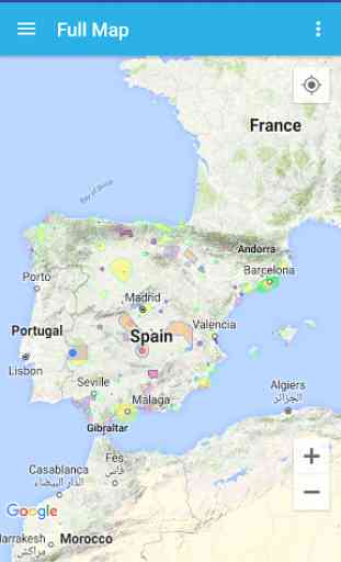
IcarusRPA is a map based tool that shows graphicly the flying restrictions involving RPAs in Spain. All performance data havce been adapted from the AIP (Aerocraft Information Pbls), which is the basic manual of aerocraft information basic for flying and operatin the RPAs (UAV).
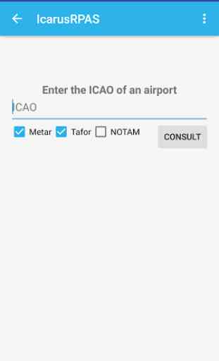
Important information afectting air operations (as Metar or Tafor of any airport -ICAO format-)can be consulted, including the notam of airpots and FIRs. The tool host different meothorologycal maps showing real-time data of windspeed, clouds and rain and the planetary K-index (Kp), used to measure the magnitude of geomagnetic storms.
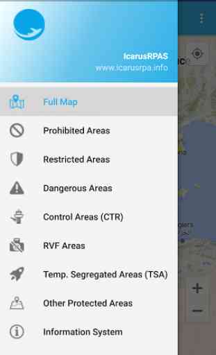
In this stage of the development of the application, the following information ois shown:
- Restricted areas,
- Hazardous areas,
- Forbidden areas,
- Control zoning (CTR),
- Fotographic flying restricted areas (ZRVF),
- Temporary Segregated areas (TSA),
- Other Protected areas,
- Aeropaces
Widget to show Kp index, two formats, icon or text view.
IcarusRPA is a map based tool that shows graphicly the flying restrictions involving RPAs in Spain. All performance data havce been adapted from the AIP (Aerocraft Information Pbls), which is the basic manual of aerocraft information basic for flying and operatin the RPAs (UAV).
Important information afectting air operations (as Metar or Tafor of any airport -ICAO format-)can be consulted, including the notam of airpots and FIRs. The tool host different meothorologycal maps showing real-time data of windspeed, clouds and rain and the planetary K-index (Kp), used to measure the magnitude of geomagnetic storms.
In this stage of the development of the application, the following information ois shown:
- Restricted areas,
- Hazardous areas,
- Forbidden areas,
- Control zoning (CTR),
- Fotographic flying restricted areas (ZRVF),
- Temporary Segregated areas (TSA),
- Other Protected areas,
- Aeropaces
Widget to show Kp index, two formats, icon or text view.
Category : Tools
Related searches
Reviews (6)
2bs.
Dec 24, 2020
It's okay but is not clear what the colours mean and areas we cannot fly. Most of the areas are open to debate if you fly sensible but is not clear if sensible or no flying.
alb.
Oct 25, 2018
Good idea but the app needs some work. Also it is still missing many areas where drone flying is not allowed.
A. G. u.
Feb 25, 2019
difficult to use. and understand the different areas
P. n. J. T.
Dec 5, 2018
Show areas where you can fly safely.
Alb. J.
Feb 18, 2017
Very helpful, it will guide you where u shall not fly in
Looks ok, but needs a key to what the colours mean on the map. Explanations are half in English & half in Spanish. Needs to improve.