
iNavX - Sailing & Boating Navigation, NOAA Charts
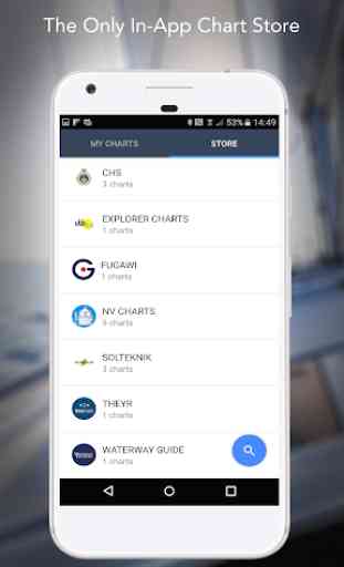
** And, the ONLY app to provide all your favorite charts from your favorite chart providers
“Editor's Choice” - Practical Sailor
"The Standard" - Cruising Magazine
"Must Have List" - Cruising World
Trusted internationally by casual and professional sailors, cruisers, boaters, fishermen, and divers.
Downloads iNavX TODAY and automatically receive a complimentary copy of the official and up-to-date high resolution NOAA RNC United States marine raster charts.
iNavX is the ONLY APP to give you access all of your favorite charts directly through the app. Fully enabled with one-touch purchase and download, iNavX gives users the most streamlined access to the broadest set of marine charts and maps from multiple providers.
• NAVIONICS
• DELIUS KLASING
• EXPLORER
• BLUE LATITUDE
• THEYR WEATHER
• WATERWAY GUIDE
• ... and more
iNavX takes handheld marine navigation to the next level.
• Anglers: Discover new fishing spots by scouting out deep holes and inlets. Locate the best fishing conditions by identifying cold fronts. Save your best fishing spots with the only app that offers unlimited markers.
• Sailors: Plan great routes with waypoint and route management. Have proactive sail management with GRIB weather forecasts. Then keep watch with integration with external AIS receivers and responders. And remember great locations by geotagging photos.
• Boaters: Stay up to date on boating conditions with weather forecasts that includes currents, winds, and swells. Then save and share great boating routes to share with the track log.
ADVANCED FEATURES - iNavX is the most feature rich app available
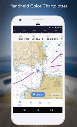
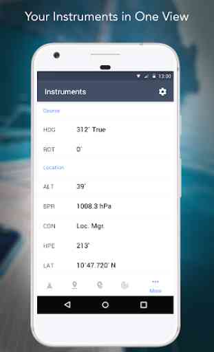
Advanced Chart Plotter
• Plot your position in real-time using your device's built-in GPS
• Easily pan, zoom, and rotate charts (including course up)
• Print a detailed chart to use in combination with the app
Advanced Navigation
• Create waypoints and plan routes to navigate between them
• Track log allows you to record your actual route
• Import/Export data in KML (Google Earth) or GPX format
REVIEWS
“iNavX is the original and still the best navigation app.” – Practical Sailor
“The most full-featured navigation app around and viewed by many as the standard” – Sail Magazine
"The #1 recommended marine charting app" - iMarineApps
Category : Maps & Navigation
Reviews (23)
Don't purchase this app. It is not user friendly, the staff are not getting back with reasonable help. You have to purchase add-ons if you want waypoints. And this gets worse. You can't Bluetooth your phone with a Tab....so you have to navigate with a small phone screen. Let me tell you it's impossible unless you have extraordinary vision.
Having used the app for eight years on iOS, I assumed that the charts I refer, Canadian Hydrographic Survey, would be available on the Android version. No such luck. Very disappointing. The only charts available are Navionics, and what advantage is there to get these through iNavX when Navionics has it own dedicated app?
I have tried a number of the marine navigation aids for phones/tablets but this is by far and away the best. A fully featured solution which provides all the functionality of a plotter minus the radar. Have used this for racing and cruises. AIS Live has made it an essential piece of equipment. I purchased navionics charts which was very economic by comparison to alternatives and essentially I now have a fully featured mobile plotter for circa $70 with all the latest maps. Great value and the support service is incredibly helpful also.
The app is not loading properly. I paid for a subscription and can't even use it. When I went to the contact us button the app opened my own private messages app. Don't understand why that would happen. If the app isn't going to work I need a refund haven't even gotten to use it.
I down loaded this and used it only one time. I didn't like it. I couldn't set my course up and the SOG was not in real time shown on the chart. None of the instruments were shown on the chart. For speed I had to continually change from chart view to instruments view. To update speed you had to change back to the chart then back to instruments for it to update. It might have been ok on a slow moving sailboat. After one trip I uninstalled and installed a different app to evaluate.
I really like iNavx on iOS. Unfortunately this android version is lacking the most important feature. Nmea tcp/ip client to connect to real GPS and to show AIS data. AIS Live is not a solution when real AIS data is available. I'll check this out again in the future. Back to navionics until this is fixed.
Great app but I switched from android tablet to a Chromebook and this app does not support Chromebook. Please add support for android app on Chromebooks. Also, when using Navionics maps on phone the text for depth soundings and other markings is too small, and text size is not adjustable in settings. Please add font size/scaling setting.
quilted the noaa charts for buzzards bay and can no longer navigate as one chart overlaps and leaves a blank space where there should be depth information. help! Marine navigator lite is free but i thought inavx would be better. I was wrong. Plus i do not like the subscription.
Bad for basic use. Not intuitive. Not easy to find free maps. Can't do basic waypoints without an upgrade. Constant ads to upgrade. Can't get off the mailing list! Unsubscribe doesn't work. Can't delete my account!
Looks like USA maps only. No local sample to find out if other country maps apply. Have to pay first, then find out. Not very nice to do it this way. Already have 4 mapping apps and only one so far does the job.
Purchased on the water with our first boat when the chartplotter stopped working. Had to navigate some skinny bay water and the app performed its job. Since then I continue to use it planning out routes, fishing spots, etc and am very happy with it.
App. is rubbish. You can't shift your starting position to plan a future route, maps don't render 1/2 the time, missing portions of maps I downloaded. TERRIBLE! Worse than useless. Move on, nothing to see here.
Unintuitive interface. Charts keep unloading when I restart phone, doesn't give compass heading for waypoints, PITA to use, most used functions for navigation - range and heading are convoluted or non functional. SOG and ETA inaccurate.
After investing considerable money in maps for North and South America I was suddenly no longer able to download them and told I needed to buy them all over again. I am happy to update for a fee but but to pull the plug on my investment was a scam pure and simple.
Downloaded to use with existing Navionics charts and TCP nmea client, and neither are supported on Android. I'm not interested in buying Navionics charts I've already purchased to use in this app. And without TCP support the app is useless anyway. Back to OpenCPN I go....
1 loaded this app for my first trip to FL. From RI. It is only fair some of the cart did not load. WAY to easy to put a way point in.then either to much on the chart or the must be deleted. I do like the measure to part. All in all pretty much a waste of time and money.
Cannot import waypoints on a Galaxy S9! I'm sure this is true with many popular Android devices. Basically you can import. You have to pay to find this out. Rip off!
Won't hold position in android P. Worked fine before update. When I switch between apps it'll update. but when I leave inavx open it take forever to update position if at all. Please assist.
No Android support for NMEA over IP yet it exist for iOS.. I'll reinstall when iNavX supports the global installed base of 87% unless I find something better in the meantime.
Doesnt work at all. Super disappointed. My friend had this app as we traveled across SF bay in the fog. Not trustworthy or more importantly your not able to see/read anything onthe app.
I'll update my rating if we can figure this out, might be me, I've been a paid subscriber for 3 years and every option you get for being a subscriber is locked yet if I click on subscribe it says that I'm already a subscriber.... help
Glitchy. Low quality maps. Hard to use. Cannot even get maps of the east of the US.
The app has great potential but it is far too glitchy to use. I bought it for a recent catamaran delivery from Grenada to fort Lauderdale--to use my phone as a backup, and for general planning. The ability to download the explorer charts for the Bahamas was useful. However the quilting is inconsistent and pretty awful honestly. Plus there were to many other glitches to use regularly. While it did serve as a backup, I will stick to my laptop programs...