komoot — Hike & Bike GPS Maps
SAVE 10€ NOW!Take 10€ off komoot’s Complete Package, our bestselling option for global exploration.Explore the world now for one low price.Hurry, this offer expires July 17!
DISCOVER TOURS
• Find the most popular Tours among the komoot Community.
• Browse Collections with hand-picked Tours and Highlight.
• With Highlights you find recommendation for amazing places and trails.
• Plan perfect Tours tailored to your fitness level and sport preferences.
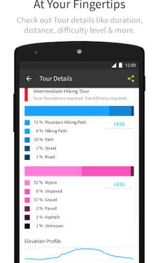
• Check out Tour characteristics like surface, difficulty, distance and elevation.
NAVIGATION & OFFLINE MAPS
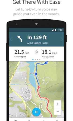
• Never take your eyes off the road with turn-by-turn voice navigation.
• Always know how fast you’re going, how far you’ve gone and how much longer you have to travel.
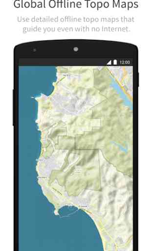
• Detailed offline maps navigate you even when the internet’s down.
SHARE YOUR ADVENTURES
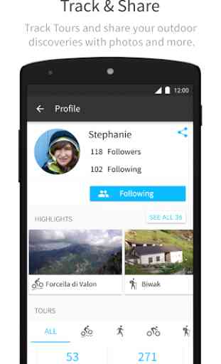
• Track your Tours, add photos and invite participants.
• Create Highlights to share your outdoor expertise with fellow outdoor people.
• Follow your friends and keep up with their outdoor adventures.
• Komoot automatically syncs across devices including your smartphone, desktop, tablet, and Android Wear.
EXPERIENCE KOMOOT FOR FREEGet your first region for free and then pay a fee to access offline maps and voice nav in other regions worldwide.
For support and tips, please visit help.komoot.de
Category : Health & Fitness
Reviews (18)
Good app for route planning, and the routes sync well with my garmin watch. 2 problems for me with the app: why can't I search for routes others have completed on the map, as I can on the website? Secondly, the 'discover' tab. It's great for finding places to go, but why can't I search for a specific region? It seems like the regions are algorithm-suggested, and sometimes you don't find the one you're after.
Great app....I have been using it over half of Europe, a lot of times without signal,before the trip I have download the map so like that had them offline.I could see the elevation that is in front of me,and on which km it is starting. One thing need to be clear though, the app completely tries to avoid the main rout with car traffic, so a lot of times you will find yourself in middle of a village,realizing that it would be better if you just continued with the main road.
I've compared all the hikes app and I really enjoy this one. Good interface. You can record your hikes to do it again later on. You can share it with friends on the app too. You can add pictures during the hikes and their geo-localisation is recorded too. Offline option available for a small fee. The design makes it fun to look at the hikes you've made and the different stats. The path chosen to go from point A to B is clever. Not overloaded with informations for a better user experience. Great
I like the work don by the folks at Komoot. However, while certainly a newcomer, I found some shortcomings which were a little disappointing. The navigation us excellent and so the reporting. Many features are really helpful. What in my view is missing is a planning tool that offers alternative routes, takes into account the preferences of the traveler and allows more fk flexibility for on the way adjustments. I tried it for my bike tour in Northern France. I thought that it did not take into consideration the fact that, like other bike tourers, I am traveling with over 35 kilogrammes (including a 13.5 kg bike). It has a scale on fitness level: however lowering my level to coach potato didn't change much. I am sure that improvements will come, but for the time being Google maps does the job ok (with some shortcomings too of course).
Some good features but unfortunately some essentials improvement needs to be done : - Impossible to exclude ferries from a tour (when you're jusy planning a run in London and you have to take 2 ferries that's a bit annoying) - You can download the maps but only plan a tour if you have network.. I've paid for the whole package but at the end I use Google Maps most of the time even if the routes are not specifically made for the sport I'm doing.
Great for discovery, sharing and navigation. Especially the voice navigation is very practical. I use voice navigation all the time with a bone conducting headphone (Aftershokz), so my ears are completely open and I can perfectly hear all environmental sounds like birds and traffic. Works with road biking, mtb and hiking. Voice navigation while mountain biking in the woods has a delay: instructions do come 20 meters too late sometimes. Komoot is working to improve this.
I would give it a 3,5. It is a great app, not perfect but really good, and plans way better routes than ie Strava. But it is not free. Sadly, you have to pay 9 bucks per region (a region is about 50 km in diameter) and 30 for the whole world. And when you just start out, you don't want to pay so much to test out, and realise you don't want the app. My advice would be, to find a voucher somewhere and sign up with that link to get a free region to start with. It is not free though, keep in mind.
Super map, i really love it, full of pedestran way, in so many country. I take a premium account for 1 year (cause of minimum terms) for the cycling map's Access . I'm just uppset to see only national way on. It doesn't get more, so i just feel to Have paid For useless. Sorry, without that's, i would put 5 stars for the free usage.
It's good, but far from perfect. My biggest gripe is the voice for routing, the voice is just way too chatty, telling me constantly to go straight at crossings or similar useless information. As far as I can see there is no way to turn that down so it only tells you when to turn.. Second set of problems arises when you leave the planned route. First of all the app tells you to turn around most of the way instead of embracing the change and really re-route you. Also, if you left the route even briefly navigation kinda breaks, the place where it should give you turning instructions is just blank. By swiping left and right a few times it sometimes comes back, but not always, This is of course caused by wrong data in the app. Yes I know, it's based on OSM data, but I would assume that this data can be autocorrected when looking at actual data from users (which you record heavily). If OSM says a street is cobblestone but there are hundreds of racebike riders going over it regularly (and fast), then it might be a good guess that this info is not correct any more.
Has lots of routes with option for downloading maps and turn by turn navigation. Something that bothered me was when i started the route in the opposite direction. It keeps trying to make me go on route and that kinda destroys the purpose of navigation.. an option to reverse route might be helpful.
No satellite map. Can't see anything when planning routes. Useless. Maps really really bad. No way to select fastest/least ascent route. No selection of road/dirt although selecting what kind of bike ride it is will adjust this slightly. Everytime you switch between windows on your phone the map is zoomed in and not where you left it. Super annoying. Very disappointed and won't renew premium.
Hi While riding using offline route i have a few repetitive problems. 1.If I want to avoid some trails (for example) the komoot will keep "dragging" me there. 2.even if I take a different route, it sometimes keeps saying "make a u turn " for an hour or more!! 3.i don't know how to "drag and drop " in order to change the route while riding, even when stopping the navigation... Appreciate any help
Nice look and feel, easy to figure everyting out, planing routes seems to be easier than on some other popular apps. Perhaps, devising a possibility of blocking the automatic transfer of certain Garmin activities would be nice (e.g. open water swimming), as would expanding favorite sports a bit (e.g. rock climbing, sea kayaking, mountaineerig). One issue though is the altitude data. It's widely inaccurate (exaggerated), and I see no way of manually correcting it.
Pretty good for planning tours, but highlights are often not real highlights as a random bench can be an mtb highlight for some people apparently. My wishlist: 1. Make it possible to create personal highlights or make liked highlights a different colour so they are easier to recognise on the map whilst planning. Or a toogle to just show personal and liked highlights?! 2. For MTB a direction for highlights would be highly beneficial (small arrow on the highlight line?).
Really great easy to use app for long tours around the world - worth the $20 to have the entire world at your finger tips allowing you to record previous tours by simply creating them, exporting, and importing them back immediately (the app asks you if you'd like to import the file you just exported) to allow you to share your pics, highlights etc. It would be easier (less confusing) if there was an option to just record an old tour without export/import since it's not that intuitive
Does a great iob but... it is definitely rough on the batteries. I did buy the world pack and wish there was a way to disable to constant nagging upgrade screen that comes up every time I open the app. It's honestly such a turn off that it makes me not even consider premium. The option is there. Show it once with a do not show again option.
This is one of the most frustrating awful mao sites to use. Doesn't map where I want to go keeps choosing routes I don't want to go down. Won't let me adjust where I want to go. Keeps choosing return route when I don't need it. Just the most awful site for mapping. A small local run to see how far it is. Uninstalled.
Pros : I use this app a lot for short and long distance bike rides. It's easy to load gpx files and edit them directly on the phone. No need to go on a website, which is a time saver and great when traveling. Cons : It drains the batteries of course... It's best to set the phone on airplane mode with only the GPS signal on. Also, I cannot stand that it takes 5 clicks to save a tour. All these useless questions are asked before saving, very annoying. Please disable this, pretty please! Merci :)