LaserSoft MapSmart
**This app requires a TruPulse 200X, TruPulse 360B/360R, TruPulse 200B, or TruPoint 300 for full functionality.**
Map, Measure & Position Smarter
MapSmart field data collection software is designed for anyone who needs to quickly and accurately map, measure, or position anything. It’s a simple yet powerful program that easily integrates with LTI laser devices and mapping accessories to turn a laser into a complete total station solution. This program was specifically designed to be easy to operate so more time can be spent mapping and collecting data rather than training. Choose to include GPS origin and offset coordinates with laser-based mapping or not. If you do, you only need to capture one perfect coordinate – all the others are mathematically calculated based on that position.
Experience the Freedom of BYOD
Mapping solutions by Laser Technology can get you from the field to the office in the least complex, most cost-effective, and most professional way vs. any other solution on the market. Assemble a hardware/software system for the way you work. Choose from a various laser options, include your high-accuracy Bluetooth GPS (or not), store your measurements on any Android device, and look at your surveys in any CAD or GIS visualization program.
Program Features
o Install, update and transfer data cable-free (no syncing necessary)
o Experience a simplified workflow optimized for a larger display
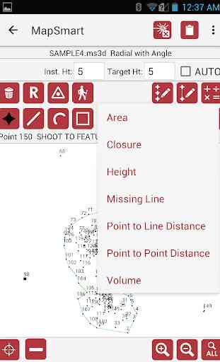
o Map with point, line, spline, and area feature types
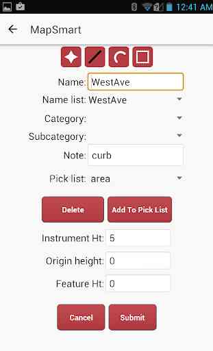
o Build custom notes, categories, and subcategories
o Assign height and missing line values to data points
o Include Photos with Measurement Data – including TruPoint 300 photos
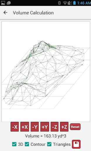
o Perform calculations (including volume) and get instant results
o Multiple report formats (DXF, CSV, GPX, PDF and more)
Requirements
Equipment: Laser Technology Incident Mapping Equipment with a TruPulse 360B, 360R, 200B, or 200X OR a TruPoint 300 laser device.
Licensing: MapSmart software requires a license in order to be fully activated.
Contact us for further information:
Laser Technology, Inc.
6912 S. Quentin St.
Centennial, CO 80112
303-649-1000
www.lasertech.com
Map, Measure & Position Smarter
MapSmart field data collection software is designed for anyone who needs to quickly and accurately map, measure, or position anything. It’s a simple yet powerful program that easily integrates with LTI laser devices and mapping accessories to turn a laser into a complete total station solution. This program was specifically designed to be easy to operate so more time can be spent mapping and collecting data rather than training. Choose to include GPS origin and offset coordinates with laser-based mapping or not. If you do, you only need to capture one perfect coordinate – all the others are mathematically calculated based on that position.
Experience the Freedom of BYOD
Mapping solutions by Laser Technology can get you from the field to the office in the least complex, most cost-effective, and most professional way vs. any other solution on the market. Assemble a hardware/software system for the way you work. Choose from a various laser options, include your high-accuracy Bluetooth GPS (or not), store your measurements on any Android device, and look at your surveys in any CAD or GIS visualization program.
Program Features
o Install, update and transfer data cable-free (no syncing necessary)
o Experience a simplified workflow optimized for a larger display
o Map with point, line, spline, and area feature types
o Build custom notes, categories, and subcategories
o Assign height and missing line values to data points
o Include Photos with Measurement Data – including TruPoint 300 photos
o Perform calculations (including volume) and get instant results
o Multiple report formats (DXF, CSV, GPX, PDF and more)
Requirements
Equipment: Laser Technology Incident Mapping Equipment with a TruPulse 360B, 360R, 200B, or 200X OR a TruPoint 300 laser device.
Licensing: MapSmart software requires a license in order to be fully activated.
Contact us for further information:
Laser Technology, Inc.
6912 S. Quentin St.
Centennial, CO 80112
303-649-1000
www.lasertech.com
Category : Productivity
Related searches
Reviews (4)
Phi. L.
Jul 9, 2020
App works extremely well when connected to one of LTI's TruPulse 360 lasers via Bluetooth. Calculates volume in the field and you can email results as s PDF.
Tri. W.
Apr 30, 2019
have try to calculate stockpile volume
S. K. M.
Feb 26, 2020
Not give sufficient time to learned.
Have been using this software for six months now, completing dozens of projects. The program works flawlessly, not using as surveyor but doing small site surveys for septic designs. Have completed a couple small traverse loops with great closure results. It's really nice to be able to send data file directly from within program to any email address. Using software with both LTI 360R. and 200X w/triangle.