Lat Long Calc Pro
Lat Long Calc Pro is an enhanced version of the free Lat Long Calc. It is a GPS tool that converts latitude/longitude coordinates to different formats and calculates distance and direction between two points.
*
* If you find a bug, e-mail me and I will fix it. **
Includes Reverse Geocoding giving you the address nearest the coordinate and elevation look up. Powered by Google. I would appreciate feedback on how these features work for you.
As requested the main screen usability has been improved including ability to pick color of result text. Note: Text may be too big or too small on some screens. You can change text size in preferences.
Of particular use in Search and Rescue (SAR) & GIS where conversion between different formats is needed. Also used by Border Patrol.
Also useful in Geocaching, surveying or anything where you need to convert coordinates between formats.
Please contact me at [email protected] for help before rating poorly.
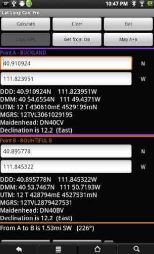
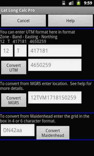
Supports DD.DDD, DD MM.MMM, DD MM SS.SSS, UTM, MGRS, USNG, OSGB Grid and Maidenhead Locator. Can load points from a GPX and/or save points in local DB for later use. Now associated with GPX files to make it easier to import.
Lets you pick a point from a map. Look for GeoPicker feature in help for how to use this. Now shows full coordinate data on point as you pick it.
Useful in orienteering.
Calculates distance between two points in feet/miles/nautical miles or meters/kilometers.
Calculates current Magnetic Declination at point. Uses WMM2010 data.
Maidenhead Locator (4 or 6 digit) is useful for Ham (Amateur) Radio contacts or contesting.
Can use internal GPS to get current position which can also be saved to a local DB.
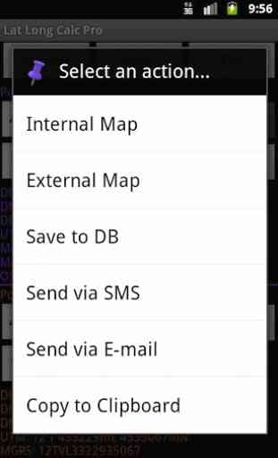
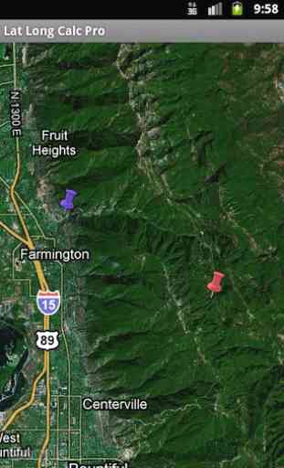
Includes internal Google mapping support as well as external mapping using Geo URIs. See your positions on a map including both at the same time. Options to use internal rendered Google Maps or external map provider such as Google Maps, VZNavigator, Locus, etc.
Long press on input fields to enter other formats.
Long press on coordinate results to show on map, send via SMS or Email, copy to the clipboard, save to the internal database or use CompassNavi based Guide Me feature. Read help for more details. With Lat Long Calc Pro SMS Plugin you can receive points in GEO URI format via SMS texts. Share points with friends and co-workers.
Does not share any information unless you send it. Internet access is for downloading your specified GPX file. GPS is only used if you select it. Basic anonymous usage info is collected by Google Analytics.
Note: Mapping support requires Google Maps be installed.
Includes color coded points including the markers on the map to make is easy to identify points.
Category : Tools
Reviews (25)
This is an awesome mapping tool!
If you need something like this it's about as food as you can get. Outstanding!
Used this work radar testing at work and the distance calculation was spot on.
this is just what I needed! tried 3 other apps first. thia is the only one that accepted DDD MM.MMM instead of DDD MM SS.SSS! completely worth the cost of pro version! would say 5 but user interface is a little non user friendly and would be better with navigate from gps pos on map too.
got the pro version and am impressed. i wanted db loading into positions a or b. got that. wanted elev lookup. got that. well worth it. thanks dev!
I use this app every day for work, I install two way satellite dish systems, this app has never let me down. Thank you
Handy utility app, runs without crashing, or error trapping.
Exactly what I need, and more. Love it!
Awesome for plotting travel through wilderness areas.
This tool is awesome!
The app was not what I was looking for. App was on devices for about one hour. Came to market for refund ans the refund button had already disappeared. App seems fine except for refunds. Guy responds after a year. Wow
Great for converting between lat/long and OS grid, etc. Feature-rich. Indispensible - I love it. John Barker
This is a pretty account program.
Does what it should
I Love this app!
This is turning out to be the most loved android gps app for many border patrol agents. Very well done sir!
It's perfect for me. Exactly what I needed
Excellent program. Superb service from Cruthu - came up with institution of my request for function within hours. Brilliant!
Great app for the price. Very reliable and easy to use
Great app, a good compliment to my existing navigation tools. Works perfectly and the developer is responsive, made requested changes quickly!
A very useful tool in the sar environment. Guaranted to save time.
Good improvements over the free version. I really like this program. Really useful in SAR. Thanks.
Many apps require coordinates in a particular format different from how you may have available. This app solves the problem. Plus a nice database feature.
Gr8 tool for orienteering, HAM and many other uses. Super job folks!
Found my way back home withwout any problem!👍👍👍 Performs as advertised.👏👏