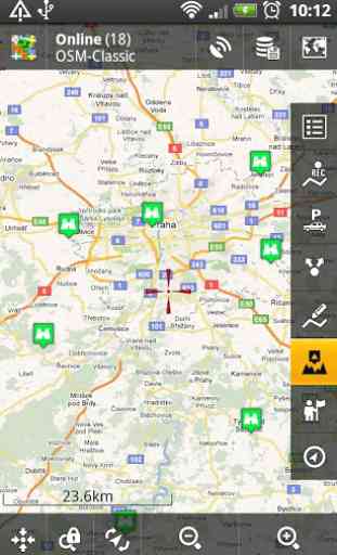
Locus Map - add-on AR
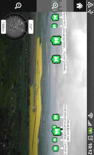
- in augmented reality. Useful during town sightseeing tours, on viewtowers, for geocaching or for simple guidance to any point. The add-on is in BETA version and works with Locus Map Pro application. In Locus Map Free, its usage is limited to 1 minute.
Add-on AR is opensource and its source code is publicly available at https://github.com/asamm/locus-addon-augmented-reality
Add-on for application Locus Map
Category : Libraries & Demo
Reviews (23)
Works well for an augmented view of your POI's etc. Only problem on my Samsung Galaxy S4 is everything is so teeny tiny I can't read anything. An option to increase the size of overlays and labels etc would be very useful. Locus maps is the best... many thanks to the dev :-)
This map app does it all and does so reliably. It is constantly updated and being developed. I find its the best for offline map ability. There are many plugins for this app that expand its functionality some of which are very practical. The layout is customizable and the behaviour can be tweaked to your liking for optimizing battery, availability etc. The battery usage is fairly decent out of the box considering all the resources that are needed to run a live navigation app. Now This app even has turn by turn navigation using vector maps though i cant attest that it is fully operational as of yet I hope that eventually it will work well enough to replace my tomtom though im not sure how j could load a tomtom map into this app.
working great on my oneplus 6. Didn't work on my htc u11 though, but other apps had compass problems too.
But sometimes points are not on the right place. Would be nice if closer points will be bigger than other.
Great add-on! But the camera image on my nexus 5x is being flipped upside down. "...the orientation of the Nexus 5X's image sensor is somewhat unconventional, and it's causing some problems within apps that are using Google's old (and now deprecated) camera API."
Why is the range of AR limited to 1545km? How can I increase it to a more international range?
Doesn't work on Galaxy Tab 10.1 original 3.1 stock ROM. The icons of sites are displayed vertically instead of horizontally over the camera image, so 90 degrees rotated. I hope it will be fixed soon, already wrote to developer, but no answer. Would be nice app.
It doesn't show the icons in the AR, it shows the little dots on the radar but it doesn't show on the camera screen. I will change the rating once it works on ZTE Blade :)
All POI 90 degrees off on my SGS3. If that can be fixed or compensated will be great.
Great tool. Only drawback is it keeps turning itself on and slows down my phone!
Also, the distance should be written next to the icon, and it would be nice to scale the icons according to their distances.
This is really nice. Keep up the updates to take care of any bugs.
Running now on HTC Desire running CyanogenMod 6.1, a bit jittery though.
Displays 3 dot menu which does nothing.
Nifty lil add-on and quite handy if you wanna see what lies between you and a POI.
does the program calculate also with altitude of the points? it doesn't seem so, unfortunatelly.. this is a serious bug for me, especially in mountains. apart from that it works fine..
Great add-on to locus
for siteseeing for top of hill..
Not yet in the market though.
Not working on x10i custom rom, froyo_Achotan v08 loads into feature and displays camera and radar but no poi labels. Just about to update to v10
Running on a Nexus 5X and it flips the image. Wasn't this tested?
think
I pick augmented reality from tools menu and nothing happens? Only works if I limit to like 30 points otherwise crashes with no information.