
Map Over Pro - Navigate With Your Own Maps
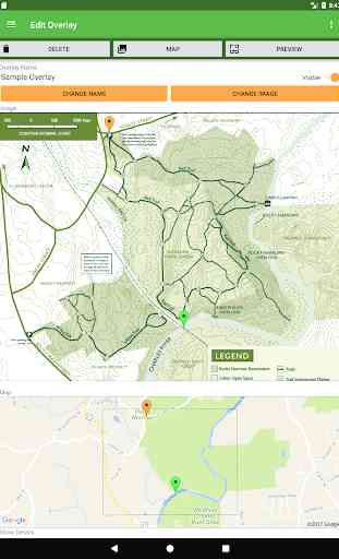
Creating an overlay is easy. Simply pick two points on any image and match them to the corresponding points on the map.
Usages include:
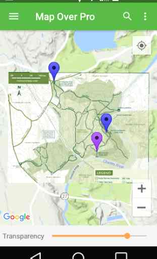
- Overlay a trail map of your local hiking, mountain biking, trail running or cross-country skiing area. Track where you are via GPS. Display the distance to your destination.
- Add an amusement park or zoo map and track where you are. Get the distance and direction to the next attraction, food area or restroom.
- Load a map of your golf course and track your location. See how far it is to the next hole or the club house.
- Are you involved in architecture, real estate, or building? Import a site map or plot plan to visualize boundaries overlaid on satellite images. Measure distances between landmarks.
Map Over Pro is ideal for geocaching. Import a list of geocaches as waypoints from any of the major geocaching web sites. Overlay a trail map and find the best route to the next cache. Drop custom waypoints for multistage caches (or mark where you park so you can navigate back to your car when you're done!)
Features:
- Overlays can be any image or a page from a PDF.
- Use GPS to display your current location.
- Create waypoints on the fly or import a list.
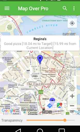
- Displays distances between your location and other waypoints.
- Map Over Pro supports unlimited overlays and waypoints.
- Use the built-in Compass to navigate to any selected waypoint.
- Adjust transparency of overlaid maps and images.
- Load images from phone memory, SD card, or Google Drive.
- Overlay images captured with your phone's camera.
- View base map in Road, Satellite, Terrain or other modes.
- Share overlays and waypoints via email, Google Drive, and more.
- Backup and restore functions.
- Built-in help.
Why use Map Over Pro?
- Have you ever found yourself navigating with a map in one hand and your phone's GPS app in your other hand?
- Have you ever thought "I wish there was a way I could overlay this map onto my phone's navigation app so it aligns, rotates and scales automatically"?
- Have you ever wanted the direction and distance to a location by just picking a point on a map?
Then Map Over Pro is for you!
Category : Maps & Navigation
Reviews (25)
For reference, I use this app when offroading or hiking where the park's own downloadable map differs heavily from google maps. This allows me to use gps on the park map instead of going back and forth. It also allows me to still see google maps as well though. So far, Ive only found 2 apps which allow you use gps on a user provided image. This one is the better app though because it also lets you adjust transparency while in the normal gps mode (the other only lets you do it in preview mode).
Phenomenal app. A real life saver when trying to navigate from photos of trail maps. Snap a photo of the map, pick a couple of points that pin it to Google maps and enjoy your hike without getting lost or taking a wrong turn ever again.
Great app! Easy to use and does what it should. Some good additions could be; - 3 point or more georeference for better accuracy - Having the option to add point, lines and polygons in the app. With approximate coordinates. - Being able to export overlays and data would be good.
Request to give provisition of selecting points more than 2 , it may be 10 or more points so that a big map in pdf can be overlay on google earth. Kindly resolve this problem. Overall app is good if above points is included. Expecting intimation in this regard. Thanking you
good start , this app would be perfect if it had stretch and skew for the overlay after its placed on the map. Ive been hoping for a app like this for a long time and this one is almost there. A little more tweeking and you've got it!
Love the app. Could have a few more features. Having issues with importing KMZ format files. Hopefully it will get resolved. But overall its a great app!!!
This would be so much better if you could pick more than 2 points when get referencing the image. Only 2 points give in inaccurate overlay. Unless I'm missing a setting?
App is not doing overlapping correctly. Overlapping of cadastral map with google earth map should be done by this app.
does not work well on my j6 samsung, search function that i need to overlay does not work, it keeps bouncing back no matter how many time i tried to search. lousy app with big ads..
This app did exactly what I wanted. I overlayed a limited entry hunting map set the points and now have full confidence that I will not exceed my legal boundaries. Thank you!
works well. please add a map over community so users can share overlays! this is what Google maps missed out on. we need to build a public overlay database
AMAZING !!! Easy To Use,To all Land Surveyor's,give it a try!!! You need No Paper Plans or Maps in the Field.Just Excellent!!!
This App is fulfilled my requirement. This is nice app. It is working in the same pattern what developers are saying.I georefereced the offline village map.I using as KMZ file.
Just what I needed and works almost perfectly. Would happily pay to remove ads.
This is great! Finally an app I can use to overlay Lake depth charts for fishing. Thanks
Simply best app in its category. Plz add map area measurement also.
Good work keep it up.. plz improve matching parameter
Please update it! It's almost perfect!
Perfect app ....every geologist need it
Sir pls update all feature
Not really helpful
Does overlays like it says
Yeah its good
best app
This is a great app to overlay my maps and to navigate to where im going. The only thing is that it would be good if i could create folders in overlays section, so not to scroll through all my maps to find one to use. If i could create folders then i can sort out all of my maps into separate folders which would be easy to find.