MapaMap Truck Europa
MapaMap Truck Europa is a GPS navigation for phones and tablets with Android ™ system designed for truck and delivery vehicle drivers traveling around Europe.
MapaMap Truck Europa is a GPS navigation designed for truck and delivery vehicle drivers traveling around Europe.
Navigation MapaMap Truck Europa will calculate the best route for a vehicle with specific parameters, taking into account restrictions for truck transport and user settings.
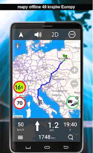
MapMap Truck Europe contains maps of 49 European countries, which are installed in the device memory or on an SD card. Navigation works in off-line mode (Internet access is not required). It is also possible to calculate routes for passenger cars.
The map of Europe contains 49 countries:
Albania, Andorra, Austria, Belgium, Belarus, Bosnia and Herzegovina, Bulgaria, Croatia, Cyprus, Montenegro, Czech Republic, Denmark, Estonia, Finland, France, Gibraltar, Greece, Spain, the Netherlands, Ireland, Iceland, Kosovo, Liechtenstein, Lithuania, Luxemburg, Latvia, Macedonia, Malta, Moldova, Monaco, Germany, Norway, Poland, Portugal, Russia, Romania, San Marino, Serbia, Slovakia, Slovenia, Switzerland, Sweden, Turkey, Ukraine, Vatican, Hungary, United Kingdom, Italy, Faroe Islands.
Maps can be downloaded and installed on the device at once, or use the special map manager function and download only the countries (maps) that you intend to use at the moment.
Emapa S.A. is the producer of the MapaMap Truck Europa navigation and the detailed map of Poland used in it. The supplier of other European countries is TomTom. Navigation is intended for consumer mobile devices with Android ™ system.
FOR TRUCKS
✓ setting individual vehicle parameters (height, width, weight, axle load)
✓ considering restrictions for heavy goods vehicles
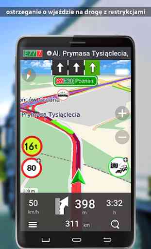
✓ warning of entering a road with truck restrictions
✓ information about traffic jams and obstructions on the road (only in Poland)
✓ blocking selected road sections
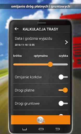
✓ avoiding toll roads and dirt roads
✓ selection of the shortest or fastest route
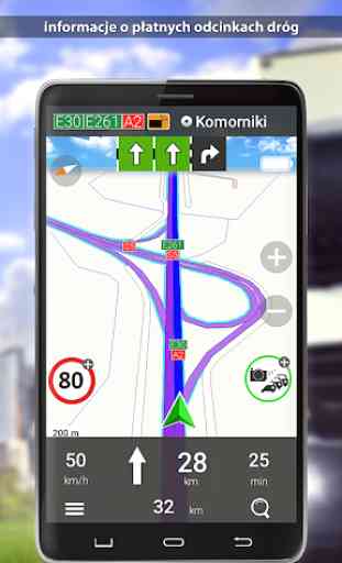
✓ information about toll roads
✓ import and export of own POIs
✓ information exchange platform between drivers (police, road control, accidents, traffic jams, etc.) supplemented by a moderator (available only in Poland)
OTHER FUNCTIONS
✓ route calculation taking into account max. 200 VIA points
✓ route planning near a specific place
✓ public utility points (POIs), including POIs providing information on parking lots and petrol stations
✓ road picketing (only in Poland)
✓ speed warning
✓ a summary of the route with the option to view it
✓ list of events with information about maneuvers
✓ save the marked route and the ability to navigate again
✓ saving the exact trace of the route traveled and the possibility of visualizing it on the map
✓ volume of voice prompts adjusted to travel speed
✓ lane assistant
✓ road signs
FREE TRIAL VERSION
The TRIAL version provides full functionality for 7 days. During or after the trial period, you can extend the operation of the application:
- 30 days (29 PLN)
- about 365 days (99 PLN)
- for an unlimited version with access to 3 subsequent updates of Europe maps (PLN 299)
MapaMap Truck Europa is a GPS navigation designed for truck and delivery vehicle drivers traveling around Europe.
Navigation MapaMap Truck Europa will calculate the best route for a vehicle with specific parameters, taking into account restrictions for truck transport and user settings.
MapMap Truck Europe contains maps of 49 European countries, which are installed in the device memory or on an SD card. Navigation works in off-line mode (Internet access is not required). It is also possible to calculate routes for passenger cars.
The map of Europe contains 49 countries:
Albania, Andorra, Austria, Belgium, Belarus, Bosnia and Herzegovina, Bulgaria, Croatia, Cyprus, Montenegro, Czech Republic, Denmark, Estonia, Finland, France, Gibraltar, Greece, Spain, the Netherlands, Ireland, Iceland, Kosovo, Liechtenstein, Lithuania, Luxemburg, Latvia, Macedonia, Malta, Moldova, Monaco, Germany, Norway, Poland, Portugal, Russia, Romania, San Marino, Serbia, Slovakia, Slovenia, Switzerland, Sweden, Turkey, Ukraine, Vatican, Hungary, United Kingdom, Italy, Faroe Islands.
Maps can be downloaded and installed on the device at once, or use the special map manager function and download only the countries (maps) that you intend to use at the moment.
Emapa S.A. is the producer of the MapaMap Truck Europa navigation and the detailed map of Poland used in it. The supplier of other European countries is TomTom. Navigation is intended for consumer mobile devices with Android ™ system.
FOR TRUCKS
✓ setting individual vehicle parameters (height, width, weight, axle load)
✓ considering restrictions for heavy goods vehicles
✓ warning of entering a road with truck restrictions
✓ information about traffic jams and obstructions on the road (only in Poland)
✓ blocking selected road sections
✓ avoiding toll roads and dirt roads
✓ selection of the shortest or fastest route
✓ information about toll roads
✓ import and export of own POIs
✓ information exchange platform between drivers (police, road control, accidents, traffic jams, etc.) supplemented by a moderator (available only in Poland)
OTHER FUNCTIONS
✓ route calculation taking into account max. 200 VIA points
✓ route planning near a specific place
✓ public utility points (POIs), including POIs providing information on parking lots and petrol stations
✓ road picketing (only in Poland)
✓ speed warning
✓ a summary of the route with the option to view it
✓ list of events with information about maneuvers
✓ save the marked route and the ability to navigate again
✓ saving the exact trace of the route traveled and the possibility of visualizing it on the map
✓ volume of voice prompts adjusted to travel speed
✓ lane assistant
✓ road signs
FREE TRIAL VERSION
The TRIAL version provides full functionality for 7 days. During or after the trial period, you can extend the operation of the application:
- 30 days (29 PLN)
- about 365 days (99 PLN)
- for an unlimited version with access to 3 subsequent updates of Europe maps (PLN 299)
Category : Maps & Navigation
Related searches