MapCam - Geo Camera & Collages
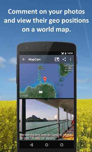
To do all this, MapCam works together with your favorite camera app and stores additional meta data in your photo files. This enables you for instance to view your pictures and photo captions on a world map at the places where you took them (see my apps EagleEye and PhotoMap). In this way, you can go on a trip again by jumping virtually from location to location.
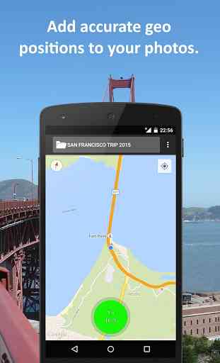
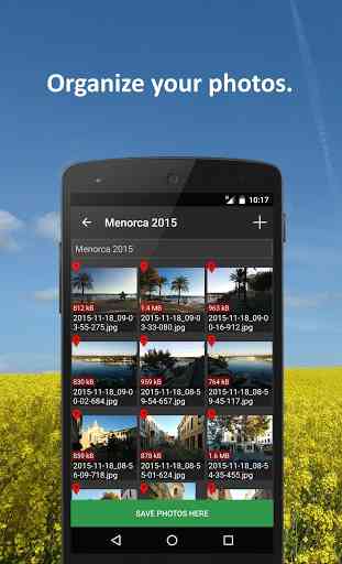
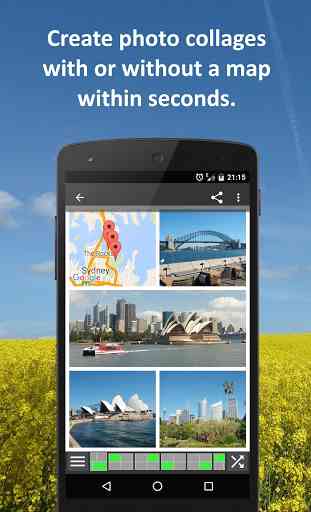
MapCam offers you the following functions:✔ Easily create and select storage folders for your photos before taking them.✔ Automatic storage of the best available degrees of latitude/longitude and altitude (in metres above sea level) in the Exif data of your photo files.✔ Add a descriptive text resp. photo caption to your pictures. The text is saved in the IPTC metadata of your photo file and does not change your photo. Picasa is able to read and show these descriptions on your PC.✔ Create geo photo collages (map and photos).✔ Share your photos just after taking them, e.g. via e-Mail, Facebook, Flickr, Google+, Instagram, MMS, Picasa, Skype, Twitter, WhatsApp, Dropbox etc.✔ Use existing camera apps. Many apps are compatible, e.g. the most preinstalled ones, Camera MX, Cymera, LINE camera, pudding camera, Camera FV-5 Lite, Camera360 Ultimate etc.
Using MapCam is simple:1. Click the round button as soon as you are happy with the detected position. The button is light green and big when the current position is precise. It is red and small when the position is imprecise.2. Take your picture: MapCam starts the default camera app or your selected one and stores the best available position in the Exif data of your photo file.3. Add a descriptive text and share your photo (optional).
Use MapCam if the position and description of photos is important to you. Here are some examples:
★ When traveling, on vacation, on business trips, when camping, at the beach, at the airport, at the train station, at the museum, etc.
★ Make a note of sites such as real estate, homes, cars, hotels, hostels, restaurants, places of work, schools, parking lots, etc.
★ During sport such as bicycling, rowing, running, jogging, skiing, snowboarding, hiking, exercising, playing football, etc.
★ As a spectator at a special event such as a concert, a festival, a soccer game, a tennis match, etc.
★ As a visitor to a park, flea markets, zoos, amusement parks, Christmas markets, etc.
★ On the weekend family outing, at a party/celebration, at a bar/nightclub, in a club, to record the night life etc.
★ When meeting with friends at the mall, on the playground, while shopping, in a restaurant, etc.
★ On special occasions such as birthdays, weddings, celebrations, parades, etc.
★ In the event of a disaster such as an earthquake, storm surge, flood, tsunami, storm, hurricane, forest fire, etc.
MapCam is interesting for the following occupational groups: real estate brokers, dealers, craftsmen, firefighters, police officers, construction workers, drivers (truck drivers, taxi drivers), event managers, foresters, gardeners, janitors, pilots, soldiers, etc.
Category : Photography
Reviews (22)
easy to use. it will helpfull if we can add shape file.
It's only in metric ,so uninstall before I even try it, I live in the UK..we hate the metric system, its useless
Excellent for all repairs and proof evidence.
Great results and easy to use!
Good reference tool
What an amazing cool app
nice.easy to use..enjoy
Friendly used.
Nice and useful, is there any way how to cut and paste from my phone to PC... thank you
Great tool
just what i i was looking for... I don't have to remember everything...just take a picture and later navigate with Google maps...except the pictures seems to disappear after sometime ...
This is a fast and simple app. The encoded GPS data is represented on the adjacent map in lightening fast speed. It is extremely helpful to catalog photos without try to retrace steps. No matter what order photos are taken in, getting them organized is a snap. The debate of; "I think it was over there instead," has been settled!
It's amazing
Bakwas
Love it on my phone but maps do not follow pictures when I forward as a text or email .?
Thanks Bro!
I love it
After confirmed purchase and payment the very bothersome ads continued to be displayed.
Thanks map cam, very usefull
Really cool
I want to make a collage with photos and a satellite map. You cannot save a map/photo with a map satellite image even though they show you one. Even using the collage maker. Does not work as advertised. You can only save the lame non satellite image. Major bug. Useless and Deleted
Great app., It really helped me with my documentation of school activities that requires geotagging and locating the coordinates.