MAPinr-KML/KMZ/WMS/GPX/OFFLINE
MAPinr is a simple (ad-free) Android app that allows you to manage your kml/kmz/gpx files and view them on different maps. MAPinr is perfect for professional use but also hiking, cycling, running, skiing, etc.
Please let us know your problems and ideas on how to improve MAPinr ([email protected]). Don't be rude just because we do not provide some functionality you were looking for. Instead drop us an email.
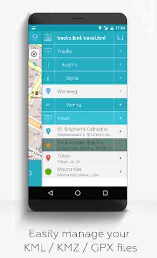
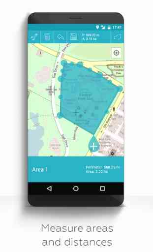
MAPinr provides the following functionality:1. Ad free / No ads2. Hierarchical folder structure for managing multiple kml/kmz/gpx files 3. Create, load, edit, save, import, export and share kml/kmz files4. Create, load, edit, save, import, export and share waypoints, lines/tracks and polygons5. Add pictures to your waypoints (to create photomaps)6. Display waypoints, lines/tracks and polygons on different maps (Google Maps, Google Satellite, Google Hybrid, OpenStreetMap (OSM), Opentopomap, Mapquest, Opencyclemap, OVI)7. Share coordinates of waypoints 8. Individually colorize waypoints, lines/tracks and polygons9. Open exported kml/kmz files in Google Earth10. Search by name, address and coordinates 11. Location-sharing to let your friends know where you are12. Display multiple kml/kmz/gpx files simultaneously 13. Merge kml/kmz files14. Google drive (gdrive) integration15. Measure distances and areas on your map16. Multilanguage (currently English, Spanish, Lithuanian)
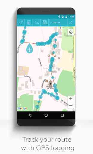
Extended features (For free with donation or like on Facebook or G; activate in Settings):1. Download maps for free / Offline maps (openstreetmap)2. GPX viewer3. Display arbitrary map data using Web Map Service (WMS), e.g., Opendata from www.data.gov4. Create custom metadata5. Upload and use custom icons6. Record GPS tracks
Compared to related apps MAPinr will not sniff into your private data or even sell it. It requires the following permissions: • Approximate location / precise location: Required to show your current location on the map. MAPinr also works with GPS fully deactivated.• Modify or delete / read the contents of your USB storage: Required for storing and loading kml/kmz files and photos.• Access Google Photos: Required to add photos from Google Photos to a waypoint. • Access to the camera to add pictures to the pins (photopoints).• Read Google service configuration: Required for map access. • Full network access: Required for downloading map data from the Internet.• In app purchase for donations (Please note that donations are a free contribution to support our work. Since we DO NOT track/store identifying data from our users donations made on one device do not unlock the features on an another device.)
Keywords: GPS tracker, GPX viewer, GPS track viewer, trails, point of interest (POI), My maps, My Tracks, My Paths, Geo Tracker, Map Free, photomap, GPS Logger, Measure Map, Hiking, GPS Position, KML viewer, Offline maps, Record GPS, Map marker, Measure area, GPS measure, Distance calculator, Measure map, agriculture, forestry, farm, farming, field management, building management, real estate management, construction, biking, traveling, skiiing, hiking, running, Fields Area Measure, property management, facility management.
Category : Travel & Local
Reviews (22)
Completely inscrutable and over-complicated user interface. All I wanted was a simple app to record my walks and drives as KML or gpx files for later analysis. I even made a donation to unlock that capability. But I couldn't get it to work. It keeps saying ”not enough points to save the file” when i try to save, but it creates some files (which are probably empty). Uninstalling
At first i liked it but within a day of usage it already crashed more than 20 times for me. It crashes on settings. It crashes on selecting map. It crashes on pining. and as of now it crashes anytime! i will give you 6 star rating if you gix the issues as i like all its features and the app itself very much. Good luck!
Confusing app. When I create a waypoint, there is no save button or way to save it on the right swipe. Has a lot of potential but needs a focus group or for devs to watch someone new to the app in order to see how they try to use it. I don't think I have the time to try to understand the simple actions I'm trying to do.
I used to like this app and used the offline maps feature often. Since it stopped working I tried clearing local app data to fix it, and now all app extended features (inc offline maps) are gone requiring me to donate again to re-enable them. From the reviews here, offline maps likely doesn't work anymore anyways. Shame.
Clunky but good enough I guess. Can't seem to find a way to close any opened maps with points. Also would be nice if we could batch select and deselect way points from some kind of list, sort of like what Google Maps allows us to do (except they only allow all or none).
It looks like a great App. I wish you could work with Maps.me as they don't have the functionality of showing different icons (the same as from the Google MyMaps), but downloading the offline maps seems better. And having an iPhone / iOS version would probably be great too.
This developer, if they ever looked at any other Android apps at all, apparently decided that they could make a better user interface than anyone had ever seen on Android before. Maybe they did, but whether you have used a few other Android apps or a few hundred, it will be easier for you to use an app that is more or less compatible with accepted practice for Android apps than to learn how to use this app's utterly eccentric, plausibly elegant, ultimately discouraging fantasy of a user interface. While this app looks like it might do the job, other apps will also, and maybe better.
Great app, really came in handy while navigating using a KMZ file, I tried using Google Earth first but it was not working when I wanted to navigate the mapped route, so I looked into playstore for alternatives and came across this app, it is a godsend as I had to complete the work that morning itself and I was stuck in the middle of nowhere. Thank You❤❤!!!
It was really good until the last update the screen size issues started. Now I'm not able click on the menu options on top left corner (half of it is outside the screen). Please correct it. Thanks
really great for geological work. two questions: whenever i export a kmz file from google earth, and then try to import it into MAPinr, it gives me an error that 'no pin in available." is there something i'm doing wrong? also, is there a way to change the colors of custom icons?
I'm not going to give a terrible review because I can tell the developer put a lot of effort into this. However, for myselfthe one kmz file that I have tested which is tropical guidance for hurricanes and I know it works in Google Earth on the PC does not load at all it says there are no waypoints.
Because of low BW and coverage in Iran I usually prefer GPS apps capable of offline maps & this app is one of best apps that I've used. Money transactions is very difficult in my country, but if I coul I definitely paid for it.
Amazing app, you can put any info you require into a kmz/kml and find it on the ground to within a few metres. I'm a land surveyor and use it to find control points
Probably the best KML viewer on android. I use this alot for work, however it is buggy. The share functionality Is currently broken and moving a point from one file to a other creates a duplicate. Keep up the good work guys, easily the best kml viewer and editor on android
It is a very good app, the only thing missing in this app is the height (Elevation) in the waypoint, I hope if there is any update, you add this feather to the app.
used to be the best kmz file app on the market, but for the past 2-3 months it has been glitchy and you can no longer drop or edit pins. please fix!!
Appears to be abandoned. Donated money to enable offline maps, they don't load. Emailed devs, no response. Tried beta with no change, left a private negative review, still no reply. Stick with the free version as the paid offers nothing.
It is a very good and useful app, but it could be better if we could really download the image of an selected area, I use it to do my field work, it helps a lot, but it has left me empty handed sometimes when I didn't have internet access
Best apps of the world. all work done at a time. But updated apps Waypoint option not work on click. Please fix it
What an amazing app. Just what I was looking for so long. Very few have guts to produce brilliance and make it free and ad-free. Hats off to you.
Cannot use offline maps one you get a update on your phone or tablet. No response from developer. Great app otherwise but not having the offline functionality is a real pain
This is a very useful app for anyone that needs to create custom map, with markers, shapes and photos. With that said, there are a few problems. First I can't really hold against the dev, but there are some major functionality issues with Android Q (Beta v3). -The camera fails to launch completely. I have tried several camera apps, they all fail. -The share feature fails completely, I can not share the KMZ to anything right now. Only work around seems to be to save the KMZ locally first, then use a file explorer to share the file. The second problem should be a pretty easy fix. The crosshair works well if the map is in street mode, but is basically invisible if you use the satellite mode. An option to change the crosshair from black to white or better still red, would solve this issue.