Mapit Spatial - GIS Data Collector
The app is designed to be simple and light, driven by new OGC file format for storing spatial data called geopackage.
Use Mapit Spatial to calculate areas, perimeters and distances - save, export and share your measurements.
The PDF user guide is available on our website - https://spatial.mapitgis.com/user-guide
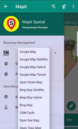
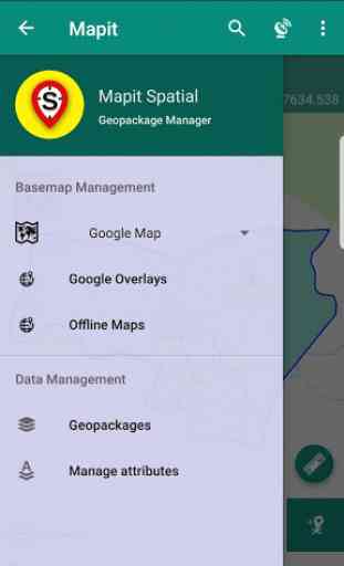
Directly from the app you can access existing multiple geopackages data sources and their content presented as tiled or feature layers.
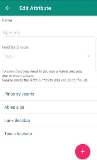
You can also create new geopackage databases and feature layers and link their fields with the attribute set fields, so the data can be then collected using forms containing drop-down lists, multi-select list, barcode scanner etc. Please see our website for more details.
The collected data can be accessed immediately by simply copying the whole geopackage file to the PC and linking to it from GIS Software like qGIS.
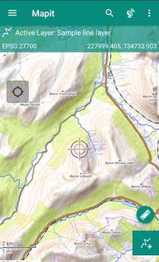
The application is supporting multiple coordinates projections and you can specify your default coordinate system by providing the EPSG code in the settings - PRJ4 library is used to convert coordinates.
The application is capable to link with high precision GNSS systems - so you can get down to centimetre accuracy if required.
With Mapit Spatial you can capture, manage and share your data easily. Supported export formats: SHP File, GeoJSON, ArcJSON, KML, GPX, CSV and AutoCAD DXF.
Mapit Spatial can be used in number of applications including:
- environmental surveys,
- woodland surveys,
- forestry planning and woodland management surveys,
- agriculture and soils' types surveys,
- road constructions,
- land surveying,
- solar panels applications,
- roofing and fencing,
- tree surveys,
- GPS and GNSS surveying,
- site surveying and soil samples gathering
- snow removal
The GIS Software and spatial data gathering and processing is getting more and
more popular these days all over the world and the ability having quick, fast
and reliable workflow is becoming very important. Mapit Pro has become a day
to day tool for thousands of people across the world and we are hoping that
Mapit Spatial is going to improve and make your workflow even more efficient
and cost-effective solution.
We would like to address our application to everyone who is working with
spatial data and is responsible for any kind of location related tasks. There is
number of science and business-related areas relying or depending on the
accurate information coming from Geographic Information Systems and we do
hope Mapit Spatial is going to become your day to day tool when you are
making things right out there in the field.
Particularly the app is dedicated to people who are working in agriculture,
forestry, housing development or land survey industry, but also to customers
responsible for design work in power industry, water supply and sewage
systems, gas industry, telecommunication and road engineering. Mapit Spatial
can be also adopted for any kind of spatial asset management tasks, fishery and
hunting, habitat and soil mapping or to whatever needs you can think off, but of
which the authors of the application have never thought.
Category : Productivity
Reviews (11)
Reliable and instinctive, I use it every day, drop and drag gpkg and image folders is very easy to export. Filtering features in list view would be good, bringing data from mapit a little confusing. I probably dont use to its potential but am very happy to incorporate Mapit Spatial into my work flow. Collecting waypoints and images is super easy and reliable.
so far so good, but I can not add image, video from my phone gallery only runs camera app (allowed permission for storage access) - thats pretty useless. Also the layer switching not very ergonomical, no icon sets for paid version, Google drive settings not available. To be honest Google map could do better as GIS if they could allow custom data sets for a point/curve/polygon. Definitelly, not worth the price.
Dear Mapit GIS LTD team, I have paid (PRO) version. Please fix gps antenna height reduction. No matter what antenna height (pole height) I enter, the altitude is the same. I have Trimble Catalyst. UPDATE: With latest update everything works like a charm. One of the most intuitive software.
Let Down I had high hopes for this and the original app to be used in the company nationally(3 yr tinkering). I haven't had luck pairing with various external GPS units not to say they don't work. The common sense navigation really isn't common sense nor can I make the premade profiles I wanted to before sending techs into the field. I believe this app will still be great for some people but not for everyone. Thought one day this may rival ESRI but it is just encumbered in different ways.
Works great! An improvement would be if it can utilize the internal compass heading in the "Navigate to Point" mode, as well as allow users to type in the coordinates when creating a new point
Good app does most things well. However, although I have a subscription, when trying to export a layer it says I am am not registered. I have to try several times to make it work. Please fix that bug to get 5 stars.
Excellent app, very happy to pay for it saved me a lot of time.
accuracy required and more options
Managing land farming easier with this apps.
Incluse the other options of measurements
This is a great app, but the paid subscription features DON'T WORK WHEN YOU'RE OFFLINE! That's a huge problem making it unusable. So, you can't add new layers if you're out of cell contact, you can't add external GPS, and numerous other features that you pay for. Absolutely crazy. The app assumed you aren't paying unless it can constantly ping to check that you are. My paid subscription is for a year. Why doesn't it just check once a year? Developers haven't replied to emails about the issue.