Maplocs - Cycling Routes, Make GPX, Send to Garmin
Built optimised for mobile experience, Maplocs has been built by passionate cyclists themselves who wanted to solve the problem of exploring and finding mountain bike routes, road cycling routes and more on the go.
Accurate Routes
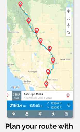
Maplocs is powered by OpenRouteService which provides highly optimised and accurate routes for mountain bikes, road bikes, regular bikes and even cars. Powered by data from Open Street Maps, Maplocs provides much accurate routes for mountain bikes and road bikes than Google Maps does.
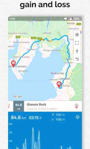
Know exactly how much climb to expect
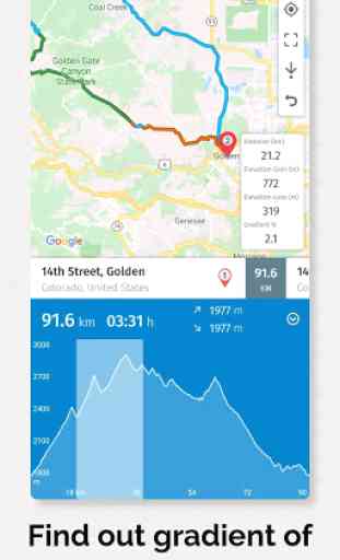
Maplocs shows elevation profile of the entire route in one very easy to access view. You can see total elevation gain and loss. Additionally on touch of the graph you can also see average gradient of each point on the route.
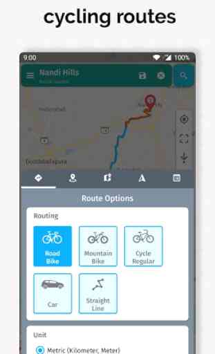
Powerful route building tools and options
Maplocs can has been built with focus only on easy route building and planning. We have paid enormous attention to making it the best cycling app for route building with features like undo, close route loop, show all points, change distance unit, accurate travel times, dragging, removing and adding points anywhere on the route and more.
Beautiful Cycling Maps
You can choose from a variety of Maps on Maplocs - Google Satellite, Hybrid or Terrain maps which also show live traffic. Also coming soon are OpenStreetMaps and cycling maps like Open Cycling Maps which is a map built for showing cycling tracks around the world.
Unlock the power of GPX
We have embraced the GPX standard to create and share tracks and routes. On Maplocs you can export your routes in GPX format to be used in Garmins, Wahoos or any other cycling comp which supported GPX. You can also share the GPX files directly to other apps from within the app. Also coming soon is viewing and importing GPX files which will enable you to plan and navigate routes received in GPX from your friends, Strava or other websites like Komoot, RideWithGPS or MapMyRide.
Send directly to Garmin and Wahoo
We love our Garmin Edge as much you do so we added the functionality to send your routes directly to the Garmin app from which you can sync to your Garmin device. We didn't leave out Wahoo either.
Your routes always with you
Doesn't matter if you're bike touring in Europe, crossing the Hardknott Pass in UK or cycling the great MTB Divide across USA, your routes will always be available to you in the app offline.
More Features Coming Soon
* Weather at Point
* Import GPX
* See elevation data for a region on the route
* Points of interest
* OpenStreetMap map tiles like OpenCycleMaps
* Follow me mode - Have the app follow your current GPS location so that you never go off track
* See climb categories - CAT 1 to 4 and HC climbs
* Import Strava routes
* Import RideWithGPS routes
Category : Maps & Navigation
Reviews (24)
Update - I had previously given a very low rating. The developer contacted me regarding the issues I had mentioned and he was very prompt in fixing all the problems. I will gladly continue to pay for the premium features as they are totally worth it, especially the weather along the route and hills on a route features. I whole heartedly recommend this app!
This is a great tool. Easy to use and very helpful when you want to avoid certain streets or to deviate from the normal route variations that google maps provide. The route you map will open in google maps and can be saved there. The route in Maplocs remains active and changeable even after saving in the app. So be careful when viewing a previously saved route in app, as it will continue to change if manipulated. The author,Ab, is considering a lock in future version. Very receptive
Hi, I'd say this is a great route planner. Thanks to the awesome developers for making it happen. Two 'features' that could be added, though. First a real app purchase, not a subscription. You'd have many potential buyers then 🤷♂️ Another is to add dark not only to the interface, but also to the map itself. Some of your 'route planning competitors' also have this so I think the devs could squeeze this little feature in.
I love it. I like cycling in mountain areas and this application makes it possible to check the elevation along the route, and modify the points to get the desired distance and elevation. It took sometime to get used to it. When it does not recognize local map, I just click the points in the map to set the route. Done..
Great for drawing maps but must export for navigation, which would be fine if it played well with other apps. All the nav apps listed either cannot properly read the file (even exported gpx) or try to "optimize" it and do their own route plan, negating the good work this app does. Would give it 9 stars if it could also do turn by turn navigation.
Developer is always responsive. App continues to be developed. Good app. One stand out flaw. When I import routes from 3rd parties via GPX they are often just imported as a start and end. You CANNOT edit the route or it deletes it. If there was an ability to "split" the route, this would be useful. Then you could edit it and click the back button. This would also be useful for routes you made yourself but want to turn into multi-day routes. I use Tracklia to split routes currently.
Great app for planning routes and seeing the elevation, the recent update is a good improvement as it gives me the option to only take roads for my road bike rather than off road routes. Two minor improvements would be to show the elevation gain/loss between two points and also when looking at the elevation route in total having the option to see which markers are where on the total elevation to see where climbs/descents are.
I am doing a paper round and wanted to plan a route and all other apps failed-either you had to pay or they had a limit of stops or some addresses weren't in their database. This is perfect! And can be used for much more than cycling. A lot of options and a more detailed map than google maps. 5/5 from me! Good job! 😊👏
it recommends roads I already know to be extremely dangerous for cyclists when there's a nearby hike & bike that isn't really out of the way. I don't mind sharing the road w/cars but I prefer it to be on streets that have two lanes, under 45mph, no blind switch backs with a single lane, & zero shoulder (not to mention the poorest lit area at night & floods easily). I recommend updating using data from VisionZero traffic fatalities to avoid dangerous, poorly constructed roads/intersections.
I've tried many bike navi apps & this is by far the best. It has loads of data & useful information & the route planner is fantastic. I'm always discovering new features. The dev updates often & they respond to questions & comments. The one gripe I have is the subscription fee model/recurring fees. Dev very kindly explained reasons for subscription model, which makes sense and the work deserves to be rewarded here!
Great, I use it for mapping my cycles and also for trying to calculate distances. The function that allows you to see elevation and descent has been a brilliant addition and makes it so handy for trying to plan in some climbs. I've recommended it to lots of friends
ED Can you change the route between 2 points without adding new one? Frustrating for me. I want to be able to elect to override the given path of a route. If I know I am going to take my bike over in a ferry or skipping a certain road, I should be able to alter the suggested path. Also if I want to add a town between two pins, I should be able to add a new pin with a search for a town I know us somewhere between this pins. It might be good for short treks, but too limited for multi-day ones.
great planner, but ... 1) enable one-time payment instead of annual subscription, 2) lack of offline maps is a big drawback
Excellent way to map out your routes. Much easier to use and cheaper option than RidewithGPS. I also love that you can export to great Navigation apps so easily. Very affordable cost for what you get. Dev is constantly making it better!
I have a premium plan, but since it's been updated, it's very difficult to create a route, and when I actually can, it crashes...I will stop to use this and go to Komoot. Waste of time and money, this app.
A great app to quickly plan routes and send to Garmin edge devices. Easy to use and integrated with google maps so you can search for places and generate and adapt routes quicker than on the Garmin edge device. Would be great if it could generate a circular route of a given km from a starting point and given general direction.
The best road biking app. Able to plan routes using maps and simple touch screen. Imperial and metric plus elevation. View off line if you get lost without a mobile signal. SIMPLY SUPERB!!
I thought it was exactly what I was looking for, except it just allows you to PLAN a route, doesn't actually guide you. I made a route, saved it, and all it did was send to my Google maps and generated a new route, one that cars would take not the route I set. Am I doing something wrong?
Great app for route planning giving accurate distances, terrain etc. Needed some help in finding out how to add routes but got excellent help from app developer. I look forward to more features.
It gets the job done and has accurate maps. The routing is extremely buggy and very frustrating to use, however. Find an alternative.
ok as long as you stick to roads.. it cant handle footpaths but the interface is good its a shame it wont snap to paths...... Edit... i refer to bridalways and footpaths all of which at least around me are mtb accessible and i use them on my mtb... the canal towpath for example
Best cycle route planner app I've used. No sign up, easy to export gpx really intuitive. Cannot recommend enough. Free version doesn't restrict usability but premium (89p per month) is well worth it.
Lacks functionality: # needs the ability to share map to a user of the same map like with a bump technology; # unable to support cycle ways you know are there but aren't on the map; # if multiple routes exist it needs to ask which you want.
I have given a four star rating because of some problems with the accuracy of the hills on route information. The developer has informed me that he is working on this. Once this is sorted I will be happy to rate this app five stars