Maply Mission Planner
Create optimized flight plans and capture images in field autonomously, regardless of whether you are a beginner or experienced pilot.
Compatible drones:
• Phantom 3 Advanced
• Phantom 3 Pro
• Phantom 4
• Phantom 4 Advanced
• Phantom 4 Pro
• Mavic Pro
Main features:
• Fully automated flight
• Flight parameters adjustments: frontal and side image overlap, altitude, resolution (GSD) and flight direction
• Off-line base map storage for flights in locations without an internet connection
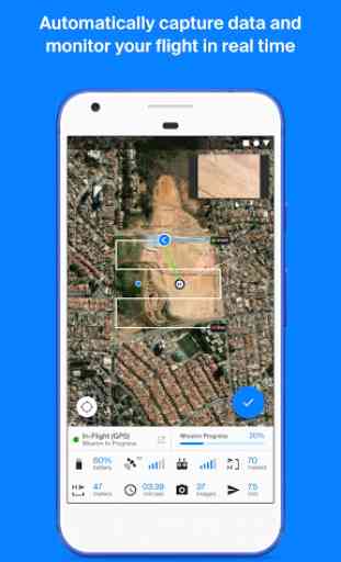
• Real-time monitoring and telemetry
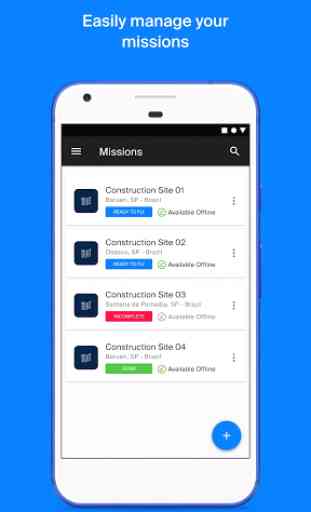
• Save and duplicate missions to fly the same area of interest several times
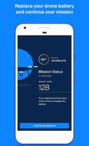
• Battery replacement capacity during missions
• Possibility to pause and continue missions
Files Outputs from Maply Web Platform:
• 2D Orthomosaic Maps
• Digital Surface Models
• 3D Models
• Point Cloud
• Contour Lines
• Inspection Images
How It Works :
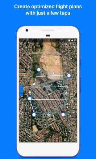
1. Tap on the “+” button to create a new mission, tapping on the satellite map the desired area to be mapped and easily adjust the flight parameters
2. While on the mission screen, connect your drone’s remote controller to your mobile device with Maply APP opened
3. As soon as the drone is connected click “Ready to fly”
4. Click on the pre-flight checklist button and wait for the preparation and loading of the mission on the drone
5. Slide the “Take off” button and the drone will take off and fly to the desired altitude and complete the mission autonomously
6. After the mission is completed the drone will fly to the home location and land itself
7. Load images into the web platform - app.maply.io and wait for the images to be processed.
Usage information
Check if you have the latest firmware installed on your drone and if the application is up to date before flying.
Compatible drones:
• Phantom 3 Advanced
• Phantom 3 Pro
• Phantom 4
• Phantom 4 Advanced
• Phantom 4 Pro
• Mavic Pro
Main features:
• Fully automated flight
• Flight parameters adjustments: frontal and side image overlap, altitude, resolution (GSD) and flight direction
• Off-line base map storage for flights in locations without an internet connection
• Real-time monitoring and telemetry
• Save and duplicate missions to fly the same area of interest several times
• Battery replacement capacity during missions
• Possibility to pause and continue missions
Files Outputs from Maply Web Platform:
• 2D Orthomosaic Maps
• Digital Surface Models
• 3D Models
• Point Cloud
• Contour Lines
• Inspection Images
How It Works :
1. Tap on the “+” button to create a new mission, tapping on the satellite map the desired area to be mapped and easily adjust the flight parameters
2. While on the mission screen, connect your drone’s remote controller to your mobile device with Maply APP opened
3. As soon as the drone is connected click “Ready to fly”
4. Click on the pre-flight checklist button and wait for the preparation and loading of the mission on the drone
5. Slide the “Take off” button and the drone will take off and fly to the desired altitude and complete the mission autonomously
6. After the mission is completed the drone will fly to the home location and land itself
7. Load images into the web platform - app.maply.io and wait for the images to be processed.
Usage information
Check if you have the latest firmware installed on your drone and if the application is up to date before flying.
Category : Tools
Related searches
I just compared 6 apps for mapping with P4Adv, and the result is interesting, this app is perfect to produce the most consistent and evenly photo point positions across Area Of Interest (AOI), i use redmi note 8 pro, i need to try this app more often, For developer can you add feature for import kml as boundary?