Mappt - Offline Mobile GIS
Mappt™ is a powerful low-barrier-to-entry GIS (Geographic Information System) app that allows users to harness the power of offline mobile data collection with one light, compact device.
Used in over 100 countries in industries spanning from education and agriculture, to mining and geology, Mappt™ is agnostic and interoperable as it works with all major desktop GIS software applications.
Mappt™’s user friendly interface hosts easy to use features that even GIS beginners will master in minutes, including:
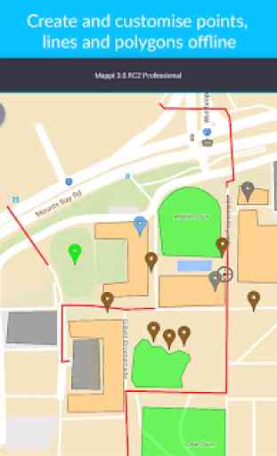
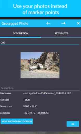
- Create, edit, store and share all types of geospatial information including points, polygons, polylines, geotagged photos and gridding
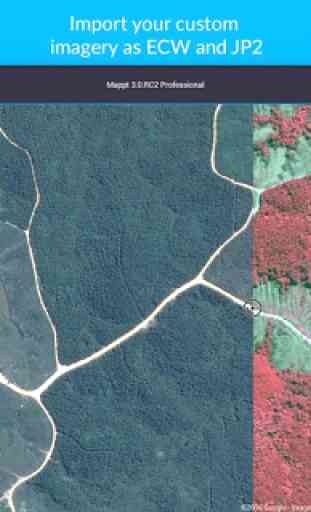
- Import unlimited sized satellite, aerial, geological, topographic, elevation and other types of imagery in ECW and JP2 format
- Import and export popular GIS formats such as Shapefiles and KML/KMZ
- Read and download a full suite of WMS/WFS & WMTS datasets
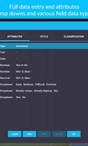
- Drop down forms for efficient field data collection
- Geofencing capabilities (perfect for in-field group work programs)
- Fully integrated offline GPS tracking
- Data operability between popular cloud storage such as Google Drive
Our clients have used our offline mobile GIS software for a range of in-field tasks including:
- Field mapping
- Land surveying
- Vegetation management
- Forestry planning
- Environmental management
- Incident reporting
- Mine management
- Farm mapping
- Utility mapping
- Government planning
- Asset management
Leave internet worries, bulky equipment, additional software and inaccurate data in the past, and experience a more efficient future of mobile geospatial technology with Mappt™.
**
* NOTE: Mappt™ requires a paid licence in order to unlock full functionality. Licences can be purchased for US$590 Standard and US$790 for Professional and renewed each year for US$110 and US$150, respectively. In addition, Mappt™ can also be purchased on a monthly basis for season or project specific users for US$60 and US$80 for Standard and Professional versions, respectively. Please visit www.mappt.com.au for more information about features and licensing tiers. ***
Category : Productivity
Reviews (28)
The Mappt app was offered to me at a special "first-year" discount of just $19 as a member of The Geological Society of America. So naturally, I expected the app could be a powerful geologic tool in the field. As it turned out, the geology features were disabled, and the only way to use the geologic tools I needed to purchase the $400+ version. It felt like a bate-and-switch. Why provide at a supposedly discounted trial rate through a Geo Society if the geo tools didn't work! Not happy!
Just advertise the fees upfront. Tick tick tict 2 hours is not enough time to test this app..... misleading and a waste of time.... otherwise, I likely would happily pay the fee, once I had time to real-life test it.
Absurd how it won't let you use the app without permission to your contacts. There is no reason for this.
easy to use, super intuitive and full of features
It could be better with speed meter
Practical and user friendly
Not free after two hours
outstandingly
Very helpful. List of improvements sent to Takor, which includes not exiting the attribute import form when lightly touching outside it. The others have reasonable workarounds.
Only wants to open in landscape. Pushed me to purchase before I got to test
Excellent product. It enables our business to save many hours of data processing.
Mappt is great. It makes data collection very easy.
Worked as intended
Even more awesome now its compatible with phones and different screen sizes! Its still way awesome!
Potentially good; however it doesn't work in portrait mode, make it pointless when using it with mounted tablets/smart phones that can not be rotated. Menu systems and deleting lays seems counter intuitive.
Love this mapping app.
Mappt is a very useful remote sensing tool particularly for use in remote areas where internet/ data access is limited or unavailable. The app allows you to cache google imagery and add in your own imagery and shapefiles. You can also create and export data in various formats (shapefiles,kml,csv). The app is very user friendly and intergrates easily with other GIS programs.
One can not Even use trail version
It has everything i need and its really work on me...
Great App, use it very day. Really helpful and dynamic App. Great work by Takor team.
Great app!! Very helpful app to collect geographic data. It's gonna be a big change at GIS field! But i suggest to reduce licence cost.
This is the best apps for various use.
It is so handy and awesome
This is a great app. It is intuitive, easy to use and a great collection tool for environmental data. This app is changing the way that people will collect data in the field, and is a fantastic all-round mobile mapping app.
GIS Manager Samsung C&T - We used multiple licenses of this product on a major WA project within the Environment and Heritage teams and the GPS, Geo-Fencing and Data Attribute features greatly empowered team members in the field, directly contributing to compliant land use. We found this a low barrier to entry field solution that fitted in well with our offline workflows. Highly recommended.
all i need for basic field mapping. More impressively it's free.
Great App! Significant improvements from previous versions! Love the photo geotagging facility for updating field capture. Fast and easy. Good value for money. Used the app to quickly capture assets for infrastructure asset management. Worked really fast on three year old Galaxy S4!
Everything works perfect, but adding a default value for each field would make the job much easier because this kind of usage usually requires changing values of 1 or 2 fields, every orher is pretty much the same so, making it posible to store a default value would make this app 5/5. Great work - keep it up :)