Maps & Navigation — OsmAnd+
OsmAnd+ is the paid application version. By buying it, you support the project, fund the development of new features, and receive the latest updates.
Some of the main features:Navigation
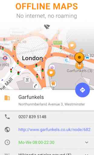
• Works online (fast) or offline (no roaming charges when you are abroad)
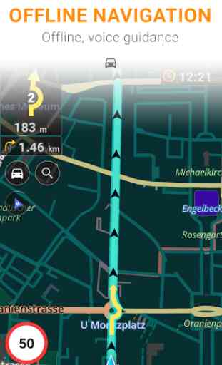
• Turn-by-turn voice guidance (recorded and synthesized voices)
• Optional lane guidance, street name display, and estimated time of arrival
• Supports intermediate points on your itinerary
• Automatic re-routing whenever you deviate from the route
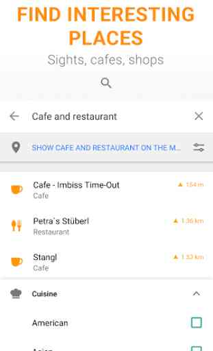
• Search for places by address, by type (e.g.: restaurant, hotel, gas station, museum), or by geographical coordinates
Map Viewing
• Display your position and orientation
• Optionally align the picture according to compass or your direction of motion
• Save your most important places as Favorites
• Display POIs (point of interests) around you
• Display specialized online tiles, satellite view (from Bing), different overlays like touring/navigation GPX tracks and additional layers with customizable transparency
• Optionally display place names in English, local, or phonetic spelling
Use OSM and Wikipedia Data
• High-quality information from the best collaborative projects of the world
• OSM data available per country or region
• Wikipedia POIs, great for sightseeing
• Unlimited free downloads, directly from the app
• Compact offline vector maps updated at least once a month
• Selection between complete region data and just road network (Example: All of Japan is 700 MB or 200 MB for the road network only)
Safety Features
• Optional automated day/night view switching
• Optional speed limit display, with reminder if you exceed it
• Optional speed-dependent zooming
• Share your location so that your friends can find you
Bicycle and Pedestrian Features
• Viewing foot, hiking, and bike paths, great for outdoor activities
• Special routing and display modes for bike and pedestrian
• Optional public transport stops (bus, tram, train) including line names
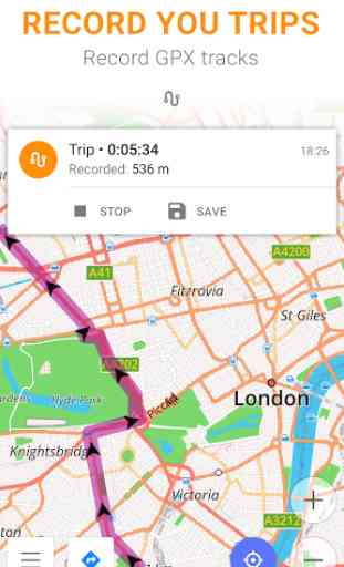
• Optional trip recording to local GPX file or online service
• Optional speed and altitude display
• Display of contour lines and hill-shading (via additional plugin)
Directly Contribute to OSM
• Report data bugs
• Upload GPX tracks to OSM directly from the app
• Add POIs and directly upload them to OSM (or later if offline)
• Optional trip recording also in background mode (while device is in sleep mode)OsmAnd is open-source and actively being developed. Everyone can contribute to the application by reporting bugs, improving translations or coding new features. The project is in a lively state of continuous improvement by all these forms of developer and user interaction. The project progress also relies on financial contributions to fund coding and testing of new functionalities. Approximate map coverage and quality:
• Western Europe: ***
*
• Eastern Europe: **
*
• Russia: **
*
• North America: **
*
• South America: *
*
• Asia: *
*
• Japan & Korea: **
*
• Middle East: *
*
• Africa: *
*
• Antarctica: *Most countries around the globe available as downloads!From Afghanistan to Zimbabwe, from Australia to the USA. Argentina, Brazil, Canada, France, Germany, Mexico, UK, Spain, ...
Category : Travel & Local
Reviews (26)
I had bough this app many years ago but I had stopped using it because at that times phones were too slow and storage too expensive to get the best out of it. I've restarted using it for hiking, and I can say that OdmAnd+ is a whole level better than much more expensive apps. No pointless social media "features", just pure map goodness.
If you're a little bit technical then this could really be the best map app for walking around in cities. It has *a lot* of details, such as benches, playgrounds, parks, wheelchair accessibility and various info about stores and restaurants, such as WiFi access. The map rendering looks great, and it's easy to see where you can find grass and parks, etc.
My go-to hiking app since 2010, when I got my first smartphone, a HTC Desire. Used it all over the world, bit mainly Europe and the US. Planning hiking trips is a breeze once you learned how the app is set up. But due it's enormous amount of functionality it is not the easiest app to master. Still 5 out of 5 stars, because it is one of the very few apps I can't live without.
So far very happy with the map! Might be a viable Google maps replacement. For Android Auto (very nicely done btw!), Please add an overview for the trip, something that would zoom out and show the whole trip, destination, duration, etc. Also, tapping or swiping through next steps is missing. Also, if the car provides GPS, GMaps can use that instead (or alongside) of the phone GPS. Might be a nice feature to add. I know AA is a new feature, just sharing my thoughts. :)
I have used Osmand for 5 years and rated 5 stars. I upgraded and I don't mind supporting the developers. Nothing I read told me this is an entirely new app that requires a separate download of maps. I wasted hours trying to workout why my phone/sd card kept running out of space. You must delete all previous maps and then the old Osmand app. I have now lost speed cameras so pay more, get less, all very frustrating.
Great app. Really useful with offline maps. Pricing is annoying though. They frequently reduce the cost to half, which even at half price, I feel is a little high for what is effectively free maps. Full price is quite frankly ridiculous.
Very slow to refresh/build screen as I move the map - not sure if this is my phone or something else (phone is a pretty up to date Oppo). Good maps lots of functionality... maybe too many menus and options.
Thank you for immediate response, distance was set to 120m for walking profile however. I set it to 500m. ------ 5 stars if you fix this: "You have been off the route for 20 meters. You are back on the route." Repeatedly! Without pausing between the two sentences - so it knows already that I am back on the route when it starts speaking - extremely annoying! Otherwise THE BEST OSM SOFTWARE OUT THERE!
OsmAnd+ is the most feature packed offline and online mapping and routing app I have used over the years. For daily navigation it is hard to beat Google Maps; however, when we embark on longer journeys especially on the road less travelled, OsmAnd+ is the tool and worth every dollar contributed.
Very good offline navigation app. However recently it sometimes behaves in an erratic way, like asking to go in the opposite direction of the actual route or do a long way round before coming back to the same place.
OsmAnd+ has such nice features, it's a real shame that the address search is so terrible. Even using the address search interface I rarely find what I am looking for. I am so confused on why it's so bad when openstreet nominatim works extremely well using conventional search strings most people are accustom to. I mostly use it as a hiking GPS since address search is so finicky.
It is definitely better. Begin to use it regularly. However, stop using indefinitely. Worst money spend for maps updates. Apps to complicated for daily usages. To many things in the map which is not practical while driving. Search for long distance destination is useless. Compare to other app i.e herewego n google map, l give osmand zero. Never use this for a while. Who ever buy this app is stupid n a dummy.
Map viewer and navigation app, capable of literally everything you would ever want from such app and much more. That comes at an expense: a steep learning curve for the UI.
I cannot understand why, when two or more hiking routs overlap, the application cannot render each hiking shield symbol separately? Now, for example when E8 overlap with any other route, for example red cross, i see only a big blue square instead of both E8 and red cross OSMC symbols. One more start down. LE: Fixed.
Really great app, has tons of features, incredibly customizable and fits a huge variety of use cases. I use this app the most when traveling outside my home country where I don't have cell service or when hiking.
Yes. Yes. Yes. This is great app. I am really enjoying it. Perhaps some suggestions: searching for navigation route would be good to speed up. Then some better sateliete maps (Microsoft earth it is terrible really). Otherwise - great app!!
I really like this app but occasionally it throws an exception saying that road calculation failed and the sync system... Omg the sync is really poorly written, buggy. Overall tho it's a great app
Fantastic mapping app. The UI can take a bit of getting familiar with, there is so there and to customize, but it's astoundingly powerful - brilliant value for money.
Great app I also have the Garmin Overlander for offroad navigation but the OsmAnd app is the leading one. The app also has far less limitations. Would be great if it would connect to the car system.
Best map app for pedestrians and cyclists in an urban environment. The most up to date and detailed information from any map app out there, and probably the best way to view OpenStreetMap data
The maps themselves are excellent, maybe the best out there. However the navigation features are lacking. Most local businesses are missing. For example, it says the closest Home Depot is over 200 mi away while there is actually one 2 mi away. Also the user interface is cumbersome for car navigation because it tries to do too many other things.
Very good offline navigation app, detailed maps, precise navigation. I'm using this app for 3 years now. Because of my job I'm kind of a globetrotter and, no matter where in the world i was, as long as I downloaded the map in advance, never had to use the data plan to navigate (sometimes unavailable, sometimes very expensive in some parts of the world if you're not local)
Update: Problem solved with an unbelievably quick response from the developer, fantastic app and fantastic support. Keep up the good work!! Hi OSM, I have an issue. (1 star for now to get your attention) map fails to render at zoom level 13 and out (not sure if I'm counting zoom level in the right direction but 10km shows on the scale when the map goes blank). I'm on a Samsung S7 and running Android 8.0. App is up to date and I've tried reinstalling to no avail. Cheers.
I have been using this app hiking and biking all over the world for 6 years. It is EXCELLENT. Osm mapping is pretty accurate, the app is stable and easy to use, and does not munch too much battery - important on multi-day camping trips. 2 minor gripes. 1. Osm mapping in the UK is a bit crappy about rights of way - all that info is crown copyright, bah. 2. If you store the maps on SD card then they can be a bit slow and laggy to render, especially if there are lots of contour lines.
I have used this app for many years for trips around the whole world, first the free version, then the paid one. I loved it. For the last few months and after a few updates, it keeps crashing and restarting everytime I start to navigate. This happens on my two android phones (samsung and xiaomi) which renders the app unusable. I am traveling to Asia in three days, have to uninstall Osmand+ and look for a different offline app. Shame.
The best navigation app ever ! Works offline, not dependent on Google (uses OSM free and open source maps, which you can modify yourself if needed). Worth paying a few euros to buy the full version ! It was the app I bought, and I really don't regret it. Working offline (without mobile data) is also nice when you are abroad, or hiking in mountains where not putting the phone in aeroplane mode can drain out your battery. Works also nicely for cycling.