Marine Navigation / Charts USA
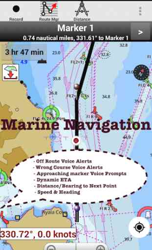
* Voice Prompts for marine navigation / nautical naviagtion (requires GPS ) -prompts on approaching a boating route marker -Continous distance and ETA updates -Alerts when sailing/boating off route -Alerts when boating in wrong direction
►Instrumentation√ Marine AIS & (NMEA AIS and GPS over TCP/UDP)√ Wind direction & Speed,Sonar depth,Water temperature
*
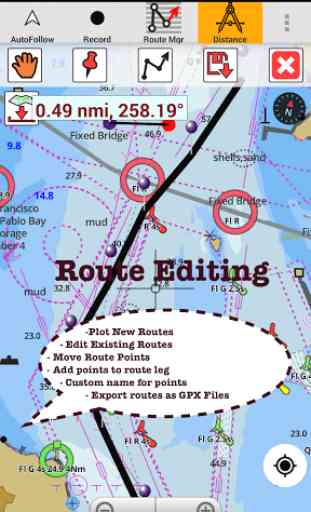
* Question? pl. contact support at gpsnauticalcharts.com / http://www.gpsnauticalcharts.com ***Route Editing/Creation -Create routes from scratch -Edit GPX/KML routes. -Add custom description to route points. -Drop markers along route.
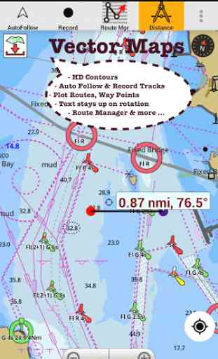
* Offline NOAA charts, USACE rivers, Lake Depth Maps(FreshWater Lakes) -Visual / Text Search -Chart Catalog -Charts reprojected for WGS84 datum
* (NEW)FreshWater Lake maps:
- 7000+ lake depth charts
- Includes boat ramps data
- 1ft / 3ft depth contour maps for anglers for selected lake maps.
- Selected lake maps also contain fishing hot spots.
- Create custom fishing hot spots
* Tide & Currents -High / Low tides. -Tidal Currents. -Active currents stations.
*Seamless chart quilting of marine charts*Distance Bearing tool*Create custom way points
- Using GPS -Select point on map -Manually enter latitude & longitude
►Custom Background Map√ Satellite imagery, street maps, topo maps & more
*Search POIs/Way points*Pan/Zoom/My Location
* Record Marine GPS tracks
* View tracks overlay
* Live track animation
* Track analytics/stats
* Export GPX trcks to SDCard -Share GPX trakcs with friends/View on Google earth.
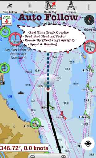
* Auto Follow Mode (Course up) -Continuously updates boat's location on chart
- Adjustable update frequencySample Nautical Charts (see http://gpsnauticalcharts.com/ for all charts)SUGARLOAF KEY TO KEY WESTPORT RICHEY TAMPA BAY
- CLEARWATER HBREAST BAY TO WEST BAY FLORIDAST JOSEPH, ST ANDREW BAYSINTRACOASTAL WATERWAY MATECUMBE TO GRASSY KEYCHESAPEAKE BAY CAPE CHARLES TO NORFOLK HARBORANCLOTE KEYS TO CRYSTAL RIVERST JOSEPH SOUNDMIAMI HARBORMinnesota lakes
- Kabetogama, Minnetonka, Waconia,Leech,Mille LacsLake Keowee,Jocassee,Hartwell,Greenwood,Lake MurrayMark Twain,Ozarks,Table RockLake St. ClairLake KentuckyKEY WEST TO THE MISSISSIPPI RIVERSAN PEDRO CHANNELLAKE MICHIGAN STONY LAKE TO POINT BETSIEAPALACHICOLA BAY TO CAPE SAN BLASEAST CAPE TO MORMON KEYCAPE HENLOPEN TO INDIAN RIVER INLETCHESAPEAKE BAY CAPE HENRY TO THIMBLE SHOAL LIGHTDULUTH-SUPERIOR HARBORMONHEGAN ISLAND TO CAPE ELIZABETHLAKE ONTARIO
- CLAYTON TO FALSE DUCKS ISLLake WinnipesaukeeSAN FRANCISCO ENTRANCEMIAMI TO MARATHON, FLORIDA BAYCAPE MAY TO FENWICK ISLANDMISSISSIPPI RIVER TO GALVESTONCAPE CANAVERAL TO KEY WESTDELAWARE RIVER WILMINGTON TO PHILADELPHIAFLORIDA KEYS SOMBRERO KEY TO SAND KEYSAN PABLO BAYRAINY LAKE BIG ISLAND MINN TO OAKPOINT ISL ONTINTRACOASTAL WATERWAY
- BISCAYNE BAYEVERGLADES NTL PARK
- SHARK RVR TO LOSTMANS RVRMIAMI TO MARATHON & FLORIDA BAYBLACKBURN BAYLAKE HURONLAKE TAHOESTRAITS OF MACKINACNORFOLK HARBOR & ELIZABETH RIVERSAN DIEGO TO SANTA ROSA ISLANDDELAWARE BAYCHOPTANK RIVER CAMBRIDGE TO GREENSBOROFORT LAUDERDALE PORT EVERGLADESST SIMONS SOUND TO TOLOMATO RIVERCHESAPEAKE DELAWARE CANALCAPE MENDOCINOSTRAIT OF JUAN DE FUCA ENTRANCEPORT RICHEY CLEARWATER HBRPAMPANO BEACH TO HALLADALE FLORIDALAKE ERIELAKE MICHIGAN INCLUDING GREEN BAYMAIMI TO MARATHON and FLORIDA BAYSANTA CATALINA ISLANDAPALACHICOLA BAY TO LAKE WIMICO
Category : Travel & Local
Reviews (28)
It seems to freeze a lot while in use. I had to buy the app for a second time because it said I did not have the pro. Very irritating.
It's a great app, the maps are very detailed. Be sure to know at least a little about marine rules before hand.
Worked great when boat gps back light died at night. Could not see where we were. Got us back to MDR in the fog.
Awesome App! Works great! Very convenient and accurate!
What a great app to have currents charts at your fingertips.
Don't know what to think about this app. I paid for it, but now I can't download/purchase charts.
everything one needs to navigate
Mot too bad could have more info
Only used twice,but it worked well
Not worth the money
Depth of water is highly inaccurate. Usually shows 6'-10' deeper than you are. Would be extremely unsafe for navigation in a boat.
Was very happy with this app for a few years. I use it for USA/Canada sailing. But now I get a constant message telling me to buy it again.
First day.short use in very difficult waterway. Worked really well.
Love this App. The raster charts flow seamlessly. Nice App to have to supplement your paper charts.
Constantly tells me to sign into google...but I'm signed in...thanks for the waste of money
Purchased app tried to follow...it said I was using the lite version
Maps are very detailed
love it
The only problem for me is that every time I press auto follow or something like that it says that I'm using the lite version and to upgrade(even though I already purchased it) and when I go to do that it gives me an error saying I have to log on the my Google play account. If any one knows how to fix it plz let me know.
I not overlay waypoints even close to their position. 10 miles offshore coordinates show me 5 miles inland.
It's what I need and more. Haven't come across any problems yet
Great application for maps ,flexibility would like to see a simulator section that would calculate various boating need such as alerts for weather ,fuel of distance best route to take etc .
Love it. I just can't get the map purchase option to work.
Use it all the time. Wish it had an AIS overlay.
Life saver when navigating new areas or at night.
Very good app. Very happy with it features and performance.
I never take my cruiser out without the charts on
DO NOT BUY!!!!!!! i purchased this app about a year ago for $20. pulled my tablet out of the boat today to get it ready for the spring the app will not work without an update and you have to purchase the update. they disabled most of the features on the old version so it's basically useless total BS. i talked to a friend of mine he had the same problem