
Marine Navigation Lite
Find your road on the sea! GPS chartplotter for boating.
An easy-to-use offline GPS tracker and route planner featuring worldwide offline maps.
Are you a sea waters traveler? Are you looking for a marine navigation tool or a GPS tracker for your Android device? Welcome to “Marine Navigation” your ultimate GPS tracker, navigator app and a route planner while you travel in the sea waters. It works perfectly and finds your way whether you are travelling in the sea waters, rivers or even the lakes. It’s a useful app for boating, fishing and sailing as well. Now you don’t need any additional navigator, instrument on your marine or boat when you travel next time. All you need is “Marine Navigation” in your Android phone.
WHAT MAKES IT A BEST GPS TRACKER OR NAVIGATOR:It’s a universal app, you can download and install this navigator on any Android device including tabs. With simple yet eye catchy graphics and interface its very easy and user friendly. The features like route information, nautical charts will help you save your time and money and you can concentrate only on the marine/boat destination.
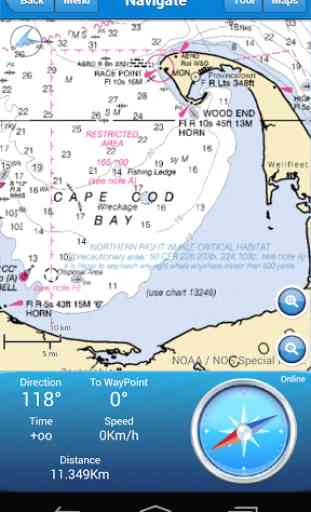
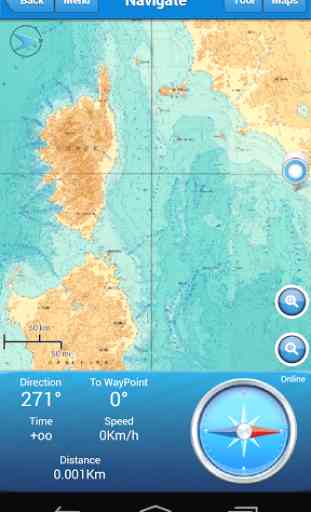
MAPS AND MARINE CHARTS
NOAA USA National Oceanic and Atmospheric Administration (NOAA), Marine Navigation use NOAA RNC raster United States waters marine charts
NOAA Mediterranean National Oceanic and Atmospheric Administration (NOAA), Marine Navigation use Bathymetric
Mediterranean RNC Mediterranean RNC (Raster Navigational Charts)
LINZ NewZealand NZMariner is the product name of New Zealand’s Official RNC (Raster Navigational Charts)
Ocean Maps Esri created and released a new, comprehensive map of the world’s oceans and coastal areas
Topo Maps This world topographic map includes boundaries, cities, water features, ports, physiographic features, ecc.
World Map Satellite imagery for the world
OpenSeaMap Open Sea Map is a first opensource maps for the sea, with ports, sea light and more.
MAPS OFFLINEYou can download maps or marine chart, you need select area and application save tile in the disk. You can navigate on preloaded maps or chart without connection.
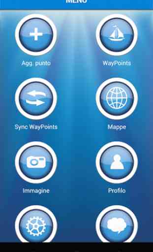
IMPORTANT FEATURES
•GPS navigator, tracker •OffLine Maps •Save on SD OfflineMaps •Sync Route/Waypoints •Interactive Map •Deep Chart / Altitude Chart •SeaPorts •Create Route/WayPoints •Way Tracking •Share an image •Anchor Alert •Screen Alive •Morse Code
GET SOCIAL:Create your Yacht Club; your best boating group.
• Login with Facebook Account
• Create Group
• Archive Points
• Share WayPoints
• Import/Export Points
GET REFUND:You have 15 minutes from the time of download to return an application purchased on Google Play for a full refund. After the 15 minute return period, don't worry, contact us on [email protected]
HELP USPlease leave a rating and review and let us know how we did on “Marine Navigation”, or what you think about it. We want to continue to deliver some of the best and useful apps for your Android devices. Your Feedback will play a big part in us being able to achieve this goal. Thanks!
WARNINGGood seamanship requires the use of official charts. Marine Navigation is for use with other charts and cannot replace official charts. Use at your own risk.
LANGUAGE
• British
• Italiano
• Français
• Espagnol
REQUIRED
• Active GPS
LEARN MORE ABOUT FISHPOINTSPlease take a look at our official website here http://www.fishpoints.net or join us of Facebook
Powered by EsriPowered By NOAAPowered By LINZ
Category : Maps & Navigation
Reviews (29)
I paid for the upgrade and it didn't work. No contact back to resolve. Don't update it cost be $10 for nothing
I paid for upgrade, I wish I didn't. Can't download maps. Two thumbs down.
Could not get it to work dont bother
it is ao helpful
Rate this app
Useless app
Beautiful, advanced
Not happy. Can not login, won't show depths of my coastline. I have not got value for money. I have sent two emails and still no response I never received a confirmation email either 😠
There is still Ads after I updated to full version forever. Why is that?
Ads literally every 20 seconds or less. Can't even use it long enough to give it a decent rating because the ads are absolutely unyielding and intrusive. Don't waste your time. Shame, could have been a decent map app.
Very clumsy to use. Maps are loaded by very small areas. I have been unable to download a usable map area. It is like trying to see a car through a 1" tube 1' away!
Some options ask to cost application that's only the problem
this is this worst app I have ever used. My tablet, a Asus, has Wifi connection only. When I purchased the product, I downloaded there NOAA maps froe the west coast. All looked well until I got outside my Wifi area. Then the maps disappeared. I confirmed that the maps were being loaded from my Wifi, by turning it off and on several times with the same results. Then I tried downloading the maps from within the application. it said "resume download". Then next screen said " No download to resume". When I'm sailing, I do not have Wifi access, So you product is worthless. I will now uninstall it. Your product is worthless.
I think it's a dick move to include images of functionality only available in the paid version in the free version images.
Bad map. No details. Cant use in finland
Cant zoom on Turkey to view any bay.
Do not waste your time with this one.
This is need only wifi conction
Do not download this app don't b s2pd lyk me
Didn't work very well wouldn't load charts if the free version is this bad not going to pay for it.
Can't download appropriate chart
I cant use this how cane we use it
To hard too install
Purports to use vector graphics charts but really uses NOAA raster charts. App crashes on startup. Worthless POS
Useless even to see if I want to pay for the upgrade. I can't get any depth data, nav aids, any useful info at all. I have no clue what this app is capable of but certainly not hoping to gamble on the paid version. DELETED
Lite version convinced me to delete this app. Tried it on a cruise ship departing Seattle and it quits showing a position when Wifi or Network is not available. Does nothing with stand alone GPS except provide a very small heading in the bottom of the screen. Twenty feet from the dock there are no maps.
The free version is no better than using Google maps. You must purchase the full version to use NOAA maps even though there are screenshots are in the description.
What a waste of download time. Does absolutely NOTHING. You can't even download or install a single chart to try out unless you buy the upgrade. Do not waste your time. Spend a few minutes to find one of the FAR better options available.
How is that possible? Purchase the app 3 years ago. Ne cellphone. Now only light version possible. An light version is useless. No maps can be downloaded. No function can used ifffff you not ubgrade - so pay again? This is really something I need answers about...