Marine Navigator
* automatic chart switching depending on current position and zoom level
* scrolling through all charts available for the current location by "press and hold" zoom buttons
* display of number of available charts for current location in the zoom buttons
* display of outlines of installed charts in active chart
* chart rotation (True North, True Course, Compass Heading, original chart orientation)
* support of non-mercator projections (Polyconic, Transverse Mercator, UTM, ...) by polynomials
* support of geodetic datum other than WGS84/NAD83 by applying northing and easting
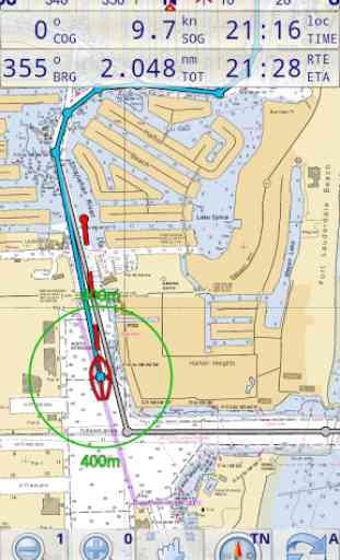
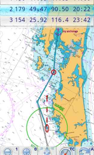
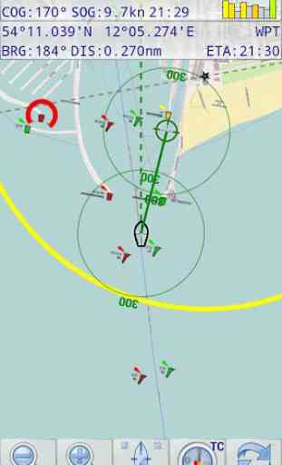
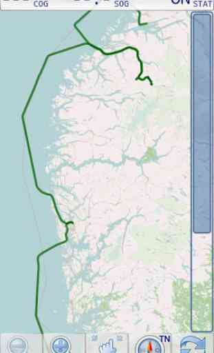
* tracks, way points, routes
* follow route automatically
* intuitive route editor
* gpx import and export of waypoints and routes
* gpx export of tracks
* recording of tracks in active and standby mode
* compass (magnetic heading, true heading, true north indicator)
* different dashboard layouts (basic data, detailed route data, detailed GPS data including graphical status info)
* Man Over Board (MOB) functions
* import and storage of installed charts in external folders
* support of encrypted charts including activation via EMAIL
* switching between chart sets (support of large number of installed charts)
Marine Navigator doesn't come with pre-installed nautical charts. Instead it is able to import BSB/KAP raster navigational charts or to use native Marine Navigator MNX-charts (see menu->help for instructions). BSB/KAP charts are available for free download on the Internet:
* http://www.nauticalcharts.noaa.gov/mcd/Raster/index.htm (Suite of NOAA nautical charts that covers the coastal waters of the U.S. and its territories)
* http://www.mar.mil.br/dhn/chm/box-cartas-raster/raster_disponiveis.html (Suite of CHM nautical charts that covers the coastal waters of Brazil and its major rivers)
* http://www.linz.govt.nz/hydro/charts/digital-charts/nzmariner (NZMariner is the product name of New Zealand's Official RNC folio.)
* http://www.openseamap.org (Openseamap charts are based on Openstreetmap data enriched with additional nautical information. The charts cover selected european coastal waters).Native Marine Navigator MNX-charts are offered by selected chart distributors. The charts are maintained by the distributor. They are not free. Further regions are coming):
* http://www.visitmyharbour.com/download-android-charts (Chart sets for UK/IRL, IBERIA, Belgium and Netherland)
* http://maps.soltek.se (Charts for Sweden and Finland)
Try before you buy: You can test the basic functions of Marine Navigator by downloading Marine Navigator Lite. If you like the app and are looking for a comprehensive set of navigational functions purchase this full version.
Category : Travel & Local
Reviews (28)
My last 5-star review was in 2015, so I figured it was time for another one. Since 2015 we have gone over 10,000 NM on the Great Lakes, including many major races and more than our share of podium finishes. Marine Navigator has been our primary navigation tool the whole time. Crew can quickly pick up how to use it. We are now on a new boat, full of all sorts of fancy built-in electronics, and I will not head offshore without my Android tablets loaded with Marine Navigator. I have recommended it o many other people. Thank you again Mr Koenig for a great product.
I installed this app on my Google Nexus 7 tablet, with uk charts from visitmyharbour. It worked brilliantly. Five stars. Now it has stopped working. It can only access the world basemap. The 400+ detailed charts all now show the lock (encrypted) icon. There might be a fix for this but I don't know what it is.
This is a wonderfull app but I cant figure out how to import Army Corps/Western Rivers charts. Ive been using this app for over 6 years for vessels 10ft to over 100ft at times, and in waters from Maine to Texas. I love the app and I just wish I could use it on the Western Rivers with Army Corps charts. Please help and I gladly give you back that last star.
In 5 years of sailing a 30 ft sailboat in the shallow waters of SW florida, I never ran aground because of this app. Can be a primary chart plotter allowing you to see your boat's position superimposed on the latest NOAA charts. I used a water proof tablet mounted on a bracket above the helm Screen was bright enough under the bimini for daylight viewing. Recommend a high current, fast charging USB cable for continuous display. Purchase permits installation on multiple devices as backup.
didnt get a chance to actually see what it will do, bought and downloaded the uk/irl chartset, but the app consistently refused to see it, (android6) , so uninstalling the app.
I have used it on a tablet as a backup system using charts from visit my harbour. It works very well. The reason I gave 4 stars instead Of 5 is the Ais add on which i have paid forkeeps asking me if I want to buy it again.
Great App at a Great Pricel Iv'e been using MN for three years now using VMH UKHO charts and it's performed faultlessly around GB from Isles of Scilly to Orkneys. I sail a yacht with a wheelhouse so the lack of weatherproofing on tablets isn't an issue for me. Would never now consider paying over the odds for a propriety chart plotter. Both Ronald Koenig the developer and Steve Bryant at VMH who supply the charts are to be heartily congratulated on making this package available.
Works well for me on klunky old kitkat tablet. Using android chartset from visit my harbour. Nice interface and nice smooth automagical choice of charts.
The best sailing program at my knowledge, in all the sense. The only problem is that it uses BSB charts which is not easy to find !
Wonderful. Having the vessel placed on a NOAA chart in and of itself gives me peace of mind. And it does so much more.
This app is absolutely superb. I am a lifelong professional sailor, and cannot praise it highly enough. Outstanding value. Alan
I have not been able to download maps for Australia cannot import waypoints nothing seems easy.
Purchased...charged me....will not install....all other apps work fine...please advise...marine navigator lite..works ...can not update to marine navigator
Great bit of kit,easy to read,easy to use.every boat should have it
Im so sad from this application because after i bought the full version, i found it not working in my region and i cant refund what i pay
Great navigation aid, use it all the time.
BEWARE ! ! In the Pacific Nothwest, this app reports erroneous latitude of approximately 26 minutes north of actual position, using a Samsung A50 phone running Android 10. A report to the developer has been unanswered.
love this app, used it on my old android. Trying to buy again but wont recognise my e-mail address.
very good, intuitive navigation app.
Great app works well with NZ charts.
The best Mobile marine app you can get.
I use this all the time works great
Brilliant. Using it with Admiralty Charts from Visitmyharbour
I've been purchased this app.. Please ride me how to download nautical chart for the Persian Gulf area...
Spot on Great app.
well worth the money
I've used the app in the St Lawrence River, which can be treacherous, and it worked flawlessly. I highly recommend it. Update: Just finished a trip down the East Coast both outside and in the ICW. Ran this on two tablets. One for large view and one for detail of our immediate vicinity. It's easy to get in trouble in the ICW and Marine Navigator kept us in the middle of the channel.
This is a very good app. Ive tried a few that I've liked yet found faults with depths,buoy positions etc. This is just as a paper chart,precise and safe to use. It's functions are smooth & easy to work out,passage planning is simple,measurements are true and reliable. I got the charts via visit my harbour and they are extremely affordable compared to some of the other offerings available.I would highly recommend this app to anyone wanting a easy to use fully functioning chart plotter. Thanks