Marine Navigator Lite
* real time positioning (instantly shows vessel's position and course on the chart)
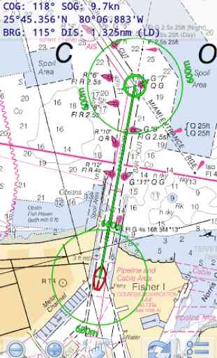
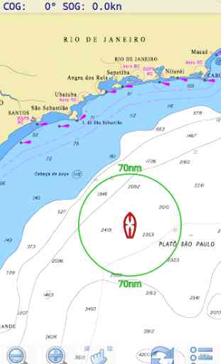
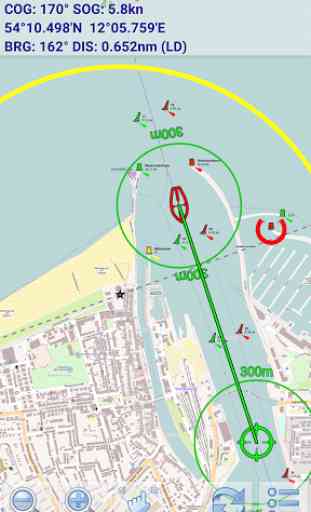
* display of navigational data (position, speed over ground, course over ground)
* distance and bearing calculationMarine Navigator Lite doesn't come with pre-installed nautical charts. Instead it is able to import BSB/KAP raster navigational charts (see menu->help for instructions). RNC's are available for free at various internet sites:*http://www.charts.noaa.gov/RNCs/RNCs.shtml (Suite of NOAA nautical charts that covers the coastal waters of the U.S. and its territories)
* http://www.mar.mil.br/dhn/chm/box-cartas-raster/raster_disponiveis.html (Suite of CHM nautical charts that covers the coastal waters of Brazil and its major rivers)
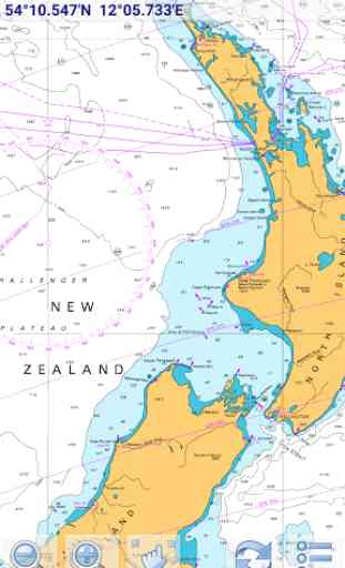
* http://www.linz.govt.nz/hydro/charts/digital-charts/nzmariner (NZMariner is the product name of New Zealand's Official RNC folio.)
* http://www.openseamap.org (Openseamap charts are based on Openstreetmap data enriched with additional nautical information. The charts cover selected european coastal waters).If you like Marine Navigator Lite and are looking for enhanced navigational functions check out the full version of MARINE NAVIGATOR.
Category : Travel & Local
Reviews (28)
Back to 5 Stars. Had problems with disappearing soft menu button on Galaxy Tab S3 due to Samsung upgrade in Oct 2019. Problems all resolved in latest upgrade and developer was great with email communication. Thanks also to Steve at VMH who helped isolate the problem and provided advice to get charts up and running again, along with recovering routes and waypoints. Buy and use with confidence - MN and VMH provide the best combination of all offerings in my opinion - with great backup.
By far the most promising chartplotter on Android. My RNCs render even better than PC based plotters. I would gladly purchase the full version and rate it 5 star, if it provides TCP, UDP based NMEA data stream. Currently I couldn't find any option to select GPS source, looks like it is locked to internal GPS (sort of thumbs down).
Simple in a good way, does what it says and does it well. Display of NOAA charts is flawless. Highly recommended and been using for over a decade! Provides excellent backup for chartplotter and allows easy updating to most recent NOAA charts. Wish I could run it on ipad.
I run this app on a Samsung Galaxy tab 2 with 8 inch screen and a Samsung galaxy 7 phone using .bsb and .kap files . There are many types of free charts" NOAA" for example , which will run on Marine Navigator Lite app on your old phones with Android 8 and lower , I would not use it on a new 1200 dollar phone . This app is simple and have been using it for years .
Nolonger can recommend. Owned full version of the application for a few years. App has not been updated since 2015. It is nolonger compatible with the latest version of Android and is now unusable.
Simple, intuitive, works great, reliable. Been using it for 10years, tried others, keep coming back to this.
The best marine navigator program. Yes, it works on Android 10+.
excellent app i use this for cjarys and as backup to chartplotter on my small 16' runabout on the great lakes
Lame navigation program, depth in meters only, don't waste your time!!!!!
Brilliant app for sailing anywhere in New Zealand with the LINZ charts downloaded.
Didn't work. After downloading the NOAA maps the app did nothing and I downloaded again and nothing
worked ok but I donr need it as much as I need the space.
Where is MN pro? I bought it and had it on my old android.
This app deserves a MUCH higher rating than 3.6. It will always show you your position on indispensable NOAA charts, which are free, and you can just touch a destination to get a bearing and distance- simple with no clutter. If you are too clueless to fetch the free charts, don't drag the rating down with 1 star reviews. Put the map zip files anwhere you like and read the extensive help files to tell the app where to find them. No need to decompress the zip files- the app does it.
For my use, the best thing about Marine Navigator Lite, is the absence of automatic chart quilting/switching. I can use it the same way I use paper charts - I reach for the chart I want. The excellent image quality means I can zoom out and see the overall view, at the scale I want, even using a magnifying glass to read details. It's great! Using MXMariner (Android) or OpenCPN (Android & Mac/Linux) the view changes automatically, the channel I'm in loses depth information, I'm zooming in and out trying for the chart I want, and the programs are in control. My thanks, Kurt
Completely useless app with zero navigation charts in app...you need to download them from other chart services so I don't see the point.
It rocks. Gotta move boat in 2 days and no longer have I phone (bye bye Apple) and lost free nav app. This one rocks once you get the chart downloader learning curve down. It does what you need it to do with no monkey business. I am going to buy the paid version as a thank you. This app is great.
With limited core memory it is important to be able to load data / charts onto the SD memory card. I hope, in the future, this app will accommodate SD memory.
Sailing or boating on the Great Lakes finds this accurate and valuable. It is my primary small boat tool, along with on hand charts. We have many modestly marked reefs, and with this tool, so easy to see and avoid. A+. A must have for me 3 yrs running. 7/2018
Worked perfectly for a 4 day coastal cruise after our GPS failed.
How do I load chart 81715 of Kwajalein? I found a hard copy I can buy, but no RNC that includes Kwajalein or Marshall Islands. Have to enable the Assistant Menu to get to the menu button on Samsung Galaxy S7. Inconvenient having to load new charts and figure out which chart you need next.
Very good aplication. Have a different app for lap top that will only do GPS via RS-232. My lap top has No serial ports. Would this app work on Windows computer with external GPS Blue Tooth input?? Very good Android app as it is. Very helpful working on 55 ton passenger tour boat.
Don't bother with this choose navionics
Junk, does nothing, tried it on multiple devices - nothing...
Checking
It does what it says
Update on the lite version of this app. Been using for over a year in the coastal waters of Florida. Still have had no issues. I have it on my phone as well as 2 different brands of tablet using a GPS receiver dongle when offshore. The Samsung users are having issues primarily due to not understanding their own hardware. Sorry guys, but it is what it is. Trying out the full version next to see how it fares. This one is a winner for me and i have recommended it multiple times to others and will continue to
Importing a set of maps for just one state took a long time. After completion the app used almost 500MB of internal storage! No obvious way to import them onto the SD card. Map image was great but only one map segment at a time is shown rather than stiched contiguous segments. Segment must be selected from long list with small font that would be hard to read in the sun. Zooming in and out is only done with the +/- icons. Promising concept but not so useful as installed.