Marine Weather | SailGrib Free
- "IMPRESSIVE"
- July 2014CRUISING WORLD
- APP OF THE MONTH
- February 2013Designed for Iridium GO! and Approved by Iridium.Sailing weather and tides forecast maps designed for and by sailors.With SailGrib, enjoy viewing weather and tide forecast on your Android device. Select the map that you want to get data for
- request the grib file, view its data on SailGrib.
- tide calculations are done directly on your device, no need for an internet connectionThe area selection is very simple: pan and zoom on the map.The data request is done through SailGrib, Saildocs,Great Circle. SailGrib gets grib files by direct download or through an email exchange.Features
- choose a map and overlay weather forecast data,
- download data using the best Grib files providers : SailGrib, Great Circle, Saildocs, MeteoConsult,...
- specify the request to your needs,
- request can be adjusted to match a maximum file size
- can be used with satellite phone email services like XGate with optimizer, the Iiridium Go or the AxcessPoint.
- offlline maps capability combined with satellite mail allows usage at sea.
- view weather overlays together on the same mapWith SailGrib, you can download and view the following data:
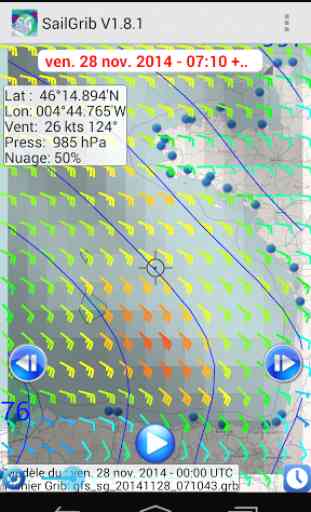
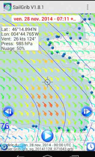
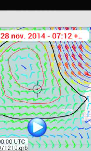
- Wind (10m above sea level)
- Pressure (reduced to mean sea level)
- Precipitation (accumulated over 6 hours)
- Total cloud cover
- Air Temperature ( 2m above ground)
- Wave (significant wave height, mean wave direction and period)
- CAPE
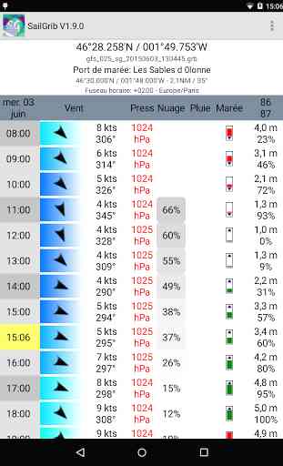
- Tidal or oceanic currentsWith SailGrib, you can specify the following parameters for your grib file request:
- grib provider : SailGrib, Great Circle, SailDocs, Open Skiron, MeteoConsult, GMN, ....
- request method : direct download (SailGrib, Great Circle, MeteoConsult, GMN) or email (Great Circle and SailDocs)
- grid resolution: from very high resolution to 2.5°
- time step between forecasts :from 1 hour to 12 hours depending on models
- number of days for the forecast: from 1 to 14 depending on model
- maximum file size. SailGrib estimates the size of the grib file you request and adjust the grid resolution and the time step to make sure your file will size be lower than your set limit.With SailGrib, you can view the following data:
- Windbarbs
- Isobars
- Precipitation maps
- Cloud cover maps
- Temperature maps
- Waves maps and arrows
- CAPE map
- CurrentsWARnING: Tide forecast are not official and are for reference purpose only.Grib files are computer-generated forecast files which are sent without review, and are offered on an as-is basis. There is no assurance that the data is accurate or correct. By using these data you agree to these limitations and assume all the responsibility for their use.SailGrib uses the JGRIB Java GRIB decoder (jgrib.sourceforge.net) and OpenStreetMap (www.openstreetmap.org).
Designed for Iridium GO! and Approved by Iridium.
Sailing weather and tides forecast maps designed for and by sailors.
With SailGrib, enjoy viewing weather and tide forecast on your Android device. Select the map that you want to get data for
- request the grib file, view its data on SailGrib.
- tide calculations are done directly on your device, no need for an internet connection
The area selection is very simple: pan and zoom on the map.The data request is done through SailGrib, Saildocs,Great Circle. SailGrib gets grib files by direct download or through an email exchange.
Features
- choose a map and overlay weather forecast data,
- download data using the best Grib files providers : SailGrib, Great Circle, Saildocs, MeteoConsult,...
- specify the request to your needs,
- request can be adjusted to match a maximum file size
- can be used with satellite phone email services like XGate with optimizer, the Iiridium Go or the AxcessPoint.
- offlline maps capability combined with satellite mail allows usage at sea.
- view weather overlays together on the same map
With SailGrib, you can download and view the following data:
- Wind (10m above sea level)
- Pressure (reduced to mean sea level)
- Precipitation (accumulated over 6 hours)
- Total cloud cover
- Air Temperature ( 2m above ground)
- Wave (significant wave height, mean wave direction and period)
- CAPE
- Tidal or oceanic currents
With SailGrib, you can specify the following parameters for your grib file request:
- grib provider : SailGrib, Great Circle, SailDocs, Open Skiron, MeteoConsult, GMN, ....
- request method : direct download (SailGrib, Great Circle, MeteoConsult, GMN) or email (Great Circle and SailDocs)
- grid resolution: from very high resolution to 2.5°
- time step between forecasts :from 1 hour to 12 hours depending on models
- number of days for the forecast: from 1 to 14 depending on model
- maximum file size. SailGrib estimates the size of the grib file you request and adjust the grid resolution and the time step to make sure your file will size be lower than your set limit.
With SailGrib, you can view the following data:
- Windbarbs
- Isobars
- Precipitation maps
- Cloud cover maps
-
Category : Weather
Reviews (29)
Quick download, reliable information, user friendly
Like using this app, gives a good indication for long range weather was
not easy to get started but great once you know it
A great app which gives all the weather info needed.
Great app. Easy to use and very accurate.
amazing reliability, easy to use
Great weather app for sailing
The App is in good working order.
Can't see the chart once the grib is displayed.
Wonky but works
Office today and tomorrow night for the next day we were going to be with him and his friends and family are doing great thanks for the first place
Does wot it states
I just subscribed to premium via option. Fast and small download which s great in limited area. Would like to see information on swell/wave height and direction.
the best what you can get for free, fast and excellent support, thanks
Haven't used it enough to know
Fabulous software, I like it
Great simple to use ap.
Excellent application for sailors!
This is best app
Great app. The most accurate I've found for So Cal Marine Waters. Catalina, Mexico, Santa Barbara. Works for me everytime. Great for planning my weekends and I'm sure when I decide to step it up it will be useful for longer distances.
I plan all my sailing trips with it. Absolutely necessary!
Love the app seems to be pretty accurate...
Brilliant, but it's important to realise that the app can only forecast the gradient winds. If coasting, the user must be aware of local effects on wind speed and direction and consequently, on the waves that they will encounter. Not a criticism, I love the app and have found the 2 day forecast to be very trustworthy. Ideal for planning a short passage or choosing a safe anchorage.
Easy fast way to get an over all pattern but realize it does not give details for small areas.
I love the concept but it's hard to navigate through the screens. I mean finding the button.
Great detail! Accurate. Only out two days in free version.
Good simple app for sailors. Lots of info well presented, minimal ornament.
Doesn't work on Samsung note 5
A great app for those who enjoy sailing. Reliable and quick files. Highly recommended