MarineTraffic ship positions
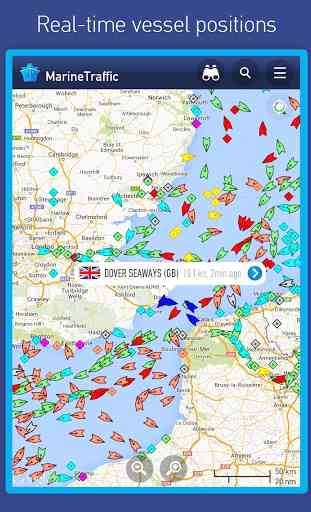
• View VESSELS ON THE LIVE MAP, search for ships, boats and seaports and see what's near you!
• More than 100,000 VESSELS PER DAY report their positions via MarineTraffic AIS
• View live wind and 48-hour WIND FORECASTS on the map
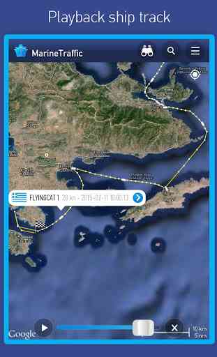
• ANIMATED PLAYBACK of vessel's track
• PORT ARRIVALS & DEPARTURES live for over 4,000 ports and marinas, current conditions in ports and estimated time of arrival for the boats & ships.
• Manage your list of vessels ("MY FLEET"), shared with all your devices and MarineTraffic.com
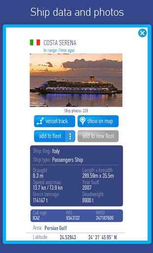
• Browse 1,5 MILLION PHOTOS of ships, harbors and lighthousesand much more!
➜ NEW! Identify vessels around you at a glance with the Augmented Reality tool (in-app purchase)Just point your device's camera to the horizon and get all the information you need about the vessels in your area: name, flag, speed, distance from you and a lot more.
Also, for MarineTraffic paying subscribers:
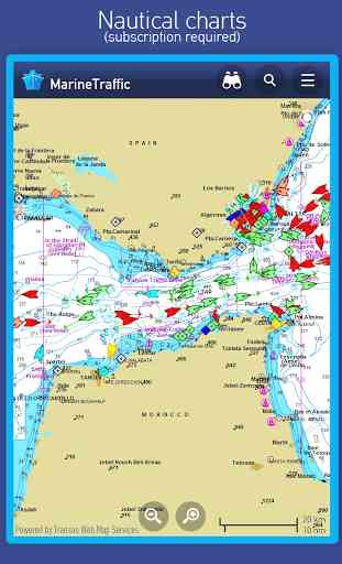
• NAUTICAL CHARTS
• SAT-AIS DATA
Join the great MarineTraffic community!
*
* If you're only interested in a specific area, please confirm coverage on www.marinetraffic.com before purchasing the app **
Category : Maps & Navigation
Reviews (15)
I paid for this app and now they tell me I can get a free starter plan for 1 year but then have to have subscription. I found the page that informs this and says to start the free year click here... I do and it sends me to the main page to navigate again only to arrive at the same spot. I would give 0 stars if I could. I have had this app for over 10 years and upgraded to paid version when requested. Now wants me to pay for subscription. I don't use enough to pay monthly. User BEWARE
It's quite good for finding boats if you know the name. However it keeps freezing particularly in the gallery section. Also I cannot find the ability to add any more vessels to my fleets. So I can't find friends yachts again easily. Used to like it better after a friend recommended it. Now it seems awkward. I'm wondering if there is a better app out there.
It's a good app to see ships in navegable waters but it does have some needs of improvement. Most importantly latitude and longitude, at the very least, 10° lines is needed and when i first purchased the app, it was fairly user friendly. Now as time goes by I'm having to purchase more features or ships data is either delayed or not there all together.
Wow. Very disappointed. I've used the site for a while now and finally made the switch to the app. Figured the $5.99 USD would be worth it because of my frequent use and how cumbersome the site is. Well it's not worth it. After you pay the $5.99 you get access but the majority of ships have their "position received by satellite". You need to pay $0.99 USD per ship to get access to info for only 24 hours. Keep your money, skip the app and just use the website.
Like a sucker I purchased the starter level subscription. What a scam for your $10 annual fee you get really nothing useful over the freebie level. Frustrating how everything is an up charge and constantly asking you to buy more, even with a subscription. Beware: subscriptions are not transferable to different devices though logged into the same account. DON'T WASTE YOUR MONEY ON A SUBSCRIPTION! Now how do I get a refund?
It's a great deal of fun to see the detailed info on the ships that I encounter. Marine Traffic is superb for learning more about these amazing craft. It's easy to configure and use for a casual enthusiast like myself. When the oppurtunity presents itself, it's gratifying to get a good photo of a ship and add it to the online library. And, for those that need in-depth/professional-level data, that is available through their subscription service.
I have used this app to identify the ships moving past me on the Ohio River. With the change to satellite, we now cannot identify anything without paying monthly. No longer worth it. I'll buy a pair of binoculars instead. Too bad, I liked the product and had already paid for the software (but you now also have to pay monthly too).
I hate that I paid for this app. It is no better at accurately showing a boats position than free versions. In fact it's worse than most. I need to when a ship is close to my bridge. Sometimes it shows them hours away when they are just minutes away. Sometimes it doesn't show a boat until it is right on me. Other times it shows the boat as sitting at the bridge long after it left. Very disappointed. I would not recommend paying for this app. I wouldn't even want this one free.
Uninstalled and reinstalled did not install icon at first. Looking good now, I plan to use it on my next cruise. Will have WiFi, it be nice to see a distant ship and indentify it. Bought the VR plug in to try out, would by weather but for somebody that is an occasional cruiser it was too expensive. Got many options, metric, imperial, nautical... starting with the default options.
This app is a money trap. First they took away the functionality it originally had, turned a one off fee into a yearly subscription. Now all I see is ships "out of range" when those same ships are quite obviously in range on the free apps. However you can buy satellite position access when other apps have the positions from coastal stations. Just a rip off. Another company that thinks it's more intelligent than its customers. If you supply these bandits with AIS data then you shouldn't. Awful.
App works really well, even just the free version is extremely useful. Only complaint is sometimes I see a "ghost" ship. What I mean by that is there will be two green arrows, but in actuality there is only one ship there. One will come up as an unidentified vessel, and the other will contain all the information of the real ship. This will correct itself if I adjust my zoom slightly.
All in all a pretty good and functional app. Paying additional 1$ for 24 hrs of satellite data is acceptable, but the fact that once 24 hrs expire you can not see the boat's last position acquired from satellite before those 24 hrs expired, is right down offending... Also, considering it's all for payment, some more details on the map would be fair.
Terribly optimized for phone. When trying to login/create an account the text is so large and improperly sized that it goes off of both sides of the screen. The app is also terribly laggy on Android 10 and probably other versions. They need to get a competent app developer to fix this because the main site works fine.
A very good app. Used to be an excellent app but since they removed the territorial water markings it has lost a bit of its usefulness, personally speaking. I say this because my main interest was/is marine traffic in and out of territorial waters. Customer services are excellent; very cordial and professional. Regarding maps and map layers there is a lot of choices except... territorial water markings.
Disappointed. I had hoped to use this for navigation related purposes but the app disclaimer says "not to be used for navigation". Not sure what else its purpose is. You can set waypoints via the "route planner" (subscription) but once you've set the route up it is "not to be used for navigation". Seems pointless having it. Anyway, of no use to me on that basis. Shame.