Maverick: GPS Navigation
• Multiple global and regional online maps, including: Bing, Yandex, Open Street Maps, OSM Cycle, OSM Public Transport, Multimap (UK), OutdoorActive (Germany, Austria, South Tyrol), Cykloatlas, HikeBikeMap (Germany), Open Piste Map, NearMap (Australia) and many other maps.
All maps automatically cached for offline use. Use Mobile Atlas Creator to download maps or MAPC2MAPC to convert maps from other formats.
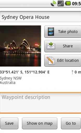
• Share your current or planned positionYou can send address, GPS coordinates, link to Google Maps and even map image.
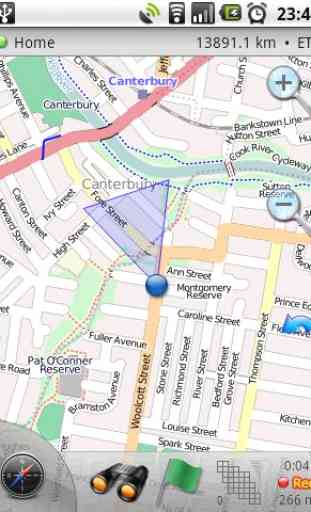
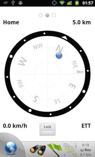
• Navigate easilyBuild-in radar shows the direction, distance and estimated time to a point of interest.
• Save places you visitAll waypoint stored in KML file and can be viewed and edited in Google Earth.
• Record tracks with single tapTracks are recorded in GPX format and can be viewed in Google Earth and other software.
• Upload tracks to GPSiesFree account is required for uploading.
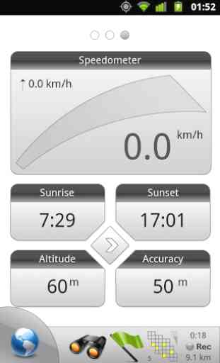
• Trip ComputerWatch speed, altitude, pitch and many other values.
Only in Pro version:
• Unlimited waypoints and tracks
• Lock compass to bearing
• UTM and OSGB grids
• OS Explorer maps
• FourSquare support
We can implement standard Google MapView, but it's limited
- no caching and terrain view. If you need it, please email us or leave a comment.
Category : Maps & Navigation
Reviews (19)
Powerful, but clunky. User interface is horrible. Many of the maps providers no longer work, and to download for offline use them you have to download each zoom level individually. Very frustrating when you just want to block out an area and download as much as you can about it. Search functions are awkward, and there is very little intuitive function. Once you get used to it then it is OK, but it's one of the poorer designs I've seen. Virtually zero documentation or user guide.
Used to be EXCELLENT, now apparently you have to PAY to download any offline apps. (Did NOT use to be that way) This used to be one of the best apps out there for offline off-road hiking and biking trails. Now it's almost useless.
It still works to a point but as other reviews have mentioned there are watermarks on the maps saying API key required. Like the paid version this free app has not been updated since Feb 2017. There are many alternatives out there which are more useful & actively developed.
This is a graveyard app. No updates in many years. Distances reported are double actual distance travelled. Background maps now have missing API key watermarks, obviously expired licences. Support page and community page links expired. Don't waste your money! It used to be groundbreaking. Current owner has no expertise in maps or gps.
Am already purchased this appa past 4 years amount wast debited my via my Postpaid Bill, so still now that payment is valid or not. This application is a one-time payment for premium?
App is outdated, the Lite version doesn't really work well. The Pro version is outdated too and development stopped, so it doesn't make any sense to buy it.
It shows straight line only and doesn't shows curves. Curves should also be shown on map so that the exact distance can be exactly calculated.
No longer downloads general, detailed maps. Only specialized maps (biking, hiking, public transport etc.), all with an irritating API-key watermark.
The app is not very good, it has now stopped showing the OS map in the scale needed for it to be useful. A waste of £6.99p to download the Pro version.
Had a topo map up started to see the options and map went away to a white screen with little blocks. Everything I tried said purchase paid pro version uninstalled
That's a sly fellow! He increased the price for the pro version, but hasn't done any update for two years. That's what I call to keep the momentum :)
The maverick; GPS Navigation system is helpful but it should be updated with all it new sites of land scape. Thanks
How could I rotate the map?? Is a pretty basic feature which does not work or is not implemented.
More accurate and simple.
Its was great app,but more great if it can zoom to 20 yard or below instead just 103 yard..Overall it was an amazing apps
When I used high DPI screen phone, the map details become too small to read. Is there anyway to improve it?
Why did mapnik stop working? Without this layer the app is completely unusable.
working good even offline would be great if i could zoom in on map more without giving me a white screen
If you are walking in Britain this is a brilliant app. Down load the Ordinance Survey Maps ( OSM). Choose your walk on the map, down load it to your phone before you leave ( in case there is no signal once out) and off you go. It tells you where you are, which direction you're heading, marks your path, add waypionts, distance/time travelled etc. Never fails. I've used it for years. Martin.